
ANOTHER FOGGY DAY. AND YEAH, IT JUST KEEPS IT REALLY COLD. WE NEED THAT SUN TO HEAT THE GROUND. LET’S GET OVER TO METEOROLOGIST OPHELIA YOUNG. I’M MISSING THE SUN. OPHELIA YOUNG THREE DAYS SINCE WE’VE SEEN THE SUN, BUT WHO’S COUNTING? I AM, IT’S GREAT ONCE AGAIN. AND THIS EVENING, THAT CLOUD LAYER DROPPING TO THE GROUND. WE’RE GOING TO WAKE UP WITH FOG TOMORROW MORNING. AGAIN, THE CLOUD LAYER CAPPED US AT 46 DEGREES MID 40S. AGAIN, THAT IS A TWO DEGREE WARM-UP FROM OUR LOW OF 44. YEAH, WE ONLY WARM TWO DEGREES TODAY. WHAT WE SHOULD HAVE FOR THIS TIME OF THE YEAR IS 57 DEGREES. ONCE AGAIN, ANOTHER EVENING WITH THOSE TEMPERATURES AREN’T GOING ANYWHERE. WE’RE STILL STUCK IN THE MID 40S. COMPARE THAT TO TRUCKEE AND SOUTH LAKE TAHOE SITTING ABOVE THE FOG LAYER THERE, DROPPING INTO THE 30S NOW. SO WHO DID SEE SOME SUNSHINE TODAY? IT DID PULL BACK ALONG THE COAST OF SAN FRANCISCO, DOWN TO THE SOUTH BAY AND THE CENTRAL COAST. THEY HAD A GORGEOUS SUNDAY, BUT HERE IN THE VALLEY ALL WE SAW WERE GRAY SKIES. EVEN UP FURTHER NORTH IN CHICO WHO SAW SOME SUNSHINE YESTERDAY. THAT’S BECAUSE HIGH PRESSURE SITTING TO OUR SOUTHWEST HASN’T BUDGED VERY MUCH. THAT MEANS THE FOG HASN’T EITHER. THE JET STREAM TO THE NORTH THAT IS STEERING ALL UNSETTLED WEATHER AWAY FROM US, BUT UNDER THE HIGH WE HAVE CALM WINDS AND THAT WARMER AIR ALOFT IS HOLDING THAT COLD AND FOGGY AIR TO OUR VALLEY SURFACE. AND GUESS WHAT? AS HIGH PRESSURE STRENGTHENS THIS WEEK, WE HAVE EVEN WARMER AIR MOVING IN OVER US. THE WINDS REMAIN CALM. THAT MEANS THAT YOUR MORNINGS ARE GOING TO GET FOGGIER THOSE CLOUD CEILINGS LOWER. BUT WE DO HAVE A SUBTLE WARMING. HOWEVER, BY THAT I MEAN WE’RE GOING TO BE WARMING FROM 47 TOMORROW BACK UP TO 50 STILL WAY BELOW THE NORMAL OF 57 DEGREES. SO FOR YOUR MORNING COMMUTE, EXPECT IT TO BE FOGGIER THIS WEEK. PATCHES OF FOG IN THE MORNING IN THE VALLEY AND ADJACENT FOOTHILLS. IT WILL BE COLD, BUT AT LEAST THE WINDS WILL BE CALM. WHEN CAN WE SEE ANY SORT OF RELIEF TO THIS JURY WEATHER? WELL, AS HIGH PRESSURE MOVES TO OUR EAST NEXT WEEKEND, I’M TALKING SATURDAY SUNDAY AND BEGINS TO BREAK DOWN. I THINK THAT’S WHEN WE CAN START ANTICIPATING THAT SUNSHINE TO RETURN. BUT UP UNTIL THEN, IT’S GOING TO BE A GRAY WEEK WITH TEMPERATURES STUCK IN THE UPPER 40S AND LOW 50S. HERE IN THE VALLEY, TEMPERATURES IN THE FOOTHILLS AND THE SIERRA ARE GOING TO BE WARMER THAN US. AUBURN AT 53 DEGREES SOUTH, LAKE TAHOE AND TRUCKEE A LITTLE WARMER IN THE MID TO UPPER 50S. WE HAVE 50 IN FAIRFIELD AND SAN FRANCISCO WILL BE WARMER THAN US TEMPERATURES IN THE UPPER 50S IN THE FOOTHILLS. A NICE DAY AHEAD, A LITTLE MORNING FOG TURNING INTO AFTERNOON SUNSHINE. BY THE END OF THE WEEK, THEY’LL BE IN THE LOW 60S. LOOK AT THE SIERRA. YOU’LL BE IN THE MID 60S BY THE END OF NEXT WEEK. QUITE A DIFFERENT STORY HERE IN THE VALLEY WITH ALL THAT FOG AND OVERCAST SKIES AS WARM AS WE’RE GOING TO G
Northern California forecast: Gray and foggy days continue this week
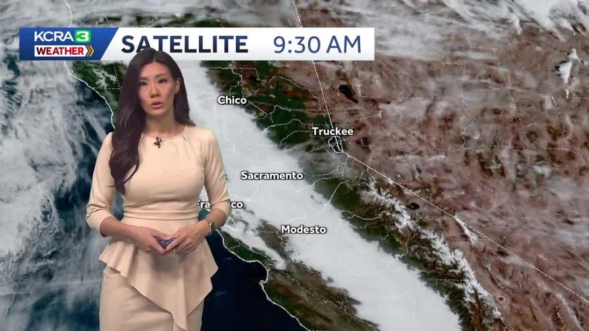
Our Tule Fog layer remains in place and may, in fact, settle in for foggier and mistier mornings this week.

Updated: 8:05 PM PST Dec 7, 2025
Our Tule Fog layer remains in place and may, in fact, settle in for foggier and mistier mornings this week.Overcast skies are once again settling onto the valley floor, and Monday will begin with widespread fog extending into the adjacent foothills. While the fog will lift off the valley floor by midday, skies will remain overcast through the afternoon, keeping valley highs in the mid- to upper 40s with light winds.Meanwhile, the weather continues to improve across most of the foothills and the Sierra. Some foothill areas near the valley, such as Auburn, may also see fog, but once it lifts around midday, skies will be mostly sunny with highs in the mid-50s at higher elevations.As high pressure moves onshore and strengthens this week, the temperature inversion responsible for daily fog development will also intensify, compressing the existing fog layer closer to the ground. Mornings may be foggier, with a lower cloud deck lasting longer into the day. However, high temperatures will warm slightly, returning to around 50 degrees by the end of the week.We anticipate the high-pressure system will weaken next weekend, bringing our next chances for the sun’s return.
SACRAMENTO, Calif. —
Our Tule Fog layer remains in place and may, in fact, settle in for foggier and mistier mornings this week.
Overcast skies are once again settling onto the valley floor, and Monday will begin with widespread fog extending into the adjacent foothills. While the fog will lift off the valley floor by midday, skies will remain overcast through the afternoon, keeping valley highs in the mid- to upper 40s with light winds.
Meanwhile, the weather continues to improve across most of the foothills and the Sierra. Some foothill areas near the valley, such as Auburn, may also see fog, but once it lifts around midday, skies will be mostly sunny with highs in the mid-50s at higher elevations.
As high pressure moves onshore and strengthens this week, the temperature inversion responsible for daily fog development will also intensify, compressing the existing fog layer closer to the ground. Mornings may be foggier, with a lower cloud deck lasting longer into the day. However, high temperatures will warm slightly, returning to around 50 degrees by the end of the week.
We anticipate the high-pressure system will weaken next weekend, bringing our next chances for the sun’s return.