
The heat of summer is in the rearview mirror as California enters the wet part of the year.
This also comes with an increased risk of flooding, especially for places like Sacramento which sits along the banks of the American and Sacramento rivers. The region has seen significant development and construction in low-lying areas and historic floodplains, which are at greater risk when waters rise.
The city and county have an extensive network of flood control infrastructure in place, from miles of levees to the Yolo Bypass, and several projects are underway to help shore up protection across the region. However, some of these projects are running into setbacks and opposition.
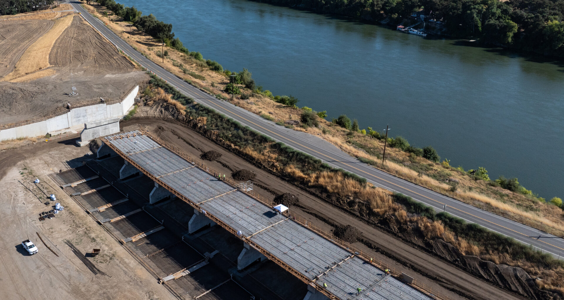
An ongoing effort to expand the 109-year-old Sacramento Weir encountered unexpected settling earlier this year along the north abutment wall. The U.S. Army Corps of Engineers says the issue could delay the project by approximately one year.
Another Army Corps project to reinforce the levees along the American River has also been challenged by local residents and conservation organizations over plans to remove hundreds of trees.
Last month a federal judge issued a preliminary injunction blocking the Corps from cutting down the trees after a lawsuit was filed by groups including the Center for Biological Diversity, Save the American River Association and American River Trees.
Jeffrey Mount is with the Water Policy Center at the nonpartisan Public Policy Institute of California.
He spoke with Insight Host Vicki Gonzalez about what the current state of Sacramento’s flood control landscape looks like.
This interview has been edited for length and clarity.
Interview highlights
Sacramento has been called one of the most flood-prone cities and areas in the country. What makes this area just so vulnerable?
It’s a number of things. First of all, this might not have been the smartest place to put a city, right at the confluence between these two rivers… in watersheds that respond very quickly to the atmospheric rivers that roll in here. Historically, as the Native American communities knew really well when they lived here, when that happened they moved… just went to higher ground.
Instead, we insisted on developing on that low ground, so our biggest challenge is we have made a series of land-use decisions that we now have to live with. How to manage floods and to deal with our flood risk in this area. One of the big mistakes we made was developing Natomas. It’s very low, it’s extremely high risk when they first started developing it and probably wasn’t a good place to build. But we’re building there.
Years ago in 1955 when they built Folsom Dam, they had announced to Sacramento, “we’ve solved your flood problem.” Oops, no you didn’t. In many ways Folsom made it worse because people went ahead and built out onto the floodplain thinking everything was fine only to discover that Folsom was just simply too small. So instead we have these thousands of miles of levees, we have weirs, we use the Yolo Bypass as a place to store and transmit flood waters, and then we have these reservoirs.
The region has historically experienced serious flooding on multiple occasions including in 1986, 1997, 2006 and 2017. What has changed in that time? Is our flood control more robust today?
My nickname is “Dr. Doom” because I’m constantly raising the alarm about these things. There’s half a million people here who are at risk of flooding, 120,000 structures, billions of dollars of investment. At the same time, after Hurricane Katrina, there was a giant wake-up particularly here in the Central Valley and in the legislature. That has been a sustained effort… the Sacramento Flood Control Agency showed extraordinary leadership and courage. Your local representatives, both Matsuis, ended up being ferocious advocates for trying to tackle the flood control problems here.
Normally I’m pretty critical about this stuff [but] I am not critical of Sacramento’s efforts. They have put in billions of dollars, in partnership with the federal government in particular. Sacramentans have done something that Californians don’t do very often: they tax themselves to help pay for this. And now you have a much much more robust flood control system than you did right after Hurricane Katrina when the national headlines were, “Sacramento, the next Hurricane Katrina.” Still got a ways to go, but you really should celebrate the progress that’s been [made] in this area.
Do you think that a majority of people living in these areas have flood insurance?
I was here in ‘86, that was very scary… such a near miss. That would have been billions of dollars, and who knows how many of these hundreds of people would have died, had it rained that hard for another 20 minutes. I haven’t forgotten that, because I’m a professional that works on that kind of stuff. Everybody else seems to have forgotten it, except the people who manage flood control. That’s one of the problems with floods because they’re short-lived, they’re over quickly and then nine months later people have forgotten about it.
You build these beautiful levees to hold back the rivers and people think they’re safe… they’re not. If you live on a floodplain behind a levee you are at risk, period. There’s this other number called residual risk. They’ll calculate what your risk is on the existing infrastructure that you have, and then there is this residual risk when it fails. There are two kinds of levees in this system, those that have failed and those that will fail. Eventually these things are undone.
When those of us get out and grind away on how to manage flood floods and reduce risk, we always come to the same conclusion. The best risk management you can do is having a good emergency evacuation system and flood insurance. But we are very worried about what’s happening at the federal level and the future of the Federal Emergency Management Agency and the National Flood Insurance Program.
The Sacramento Valley has miles of levees that need repair and upkeep, which can come with controversy. For example The U.S. Army Corps of Engineers has been working on levee upgrades along the American River Parkway which have drawn opposition and lawsuits about plans to remove hundreds of trees. How do you strike the right balance between flood control and natural preservation?
This is one of the problems of the way we developed Sacramento, we decided to put our levies right up against the river. Modern levee management and design doesn’t do that; you set those levees back as far as you possibly can to have those natural areas which become parks, recreation, etc. So the American River Parkway, as we look at it, is a flood control structure which also doubles as an important recreation area for the people of Sacramento, and there’s important wildlife habitat.
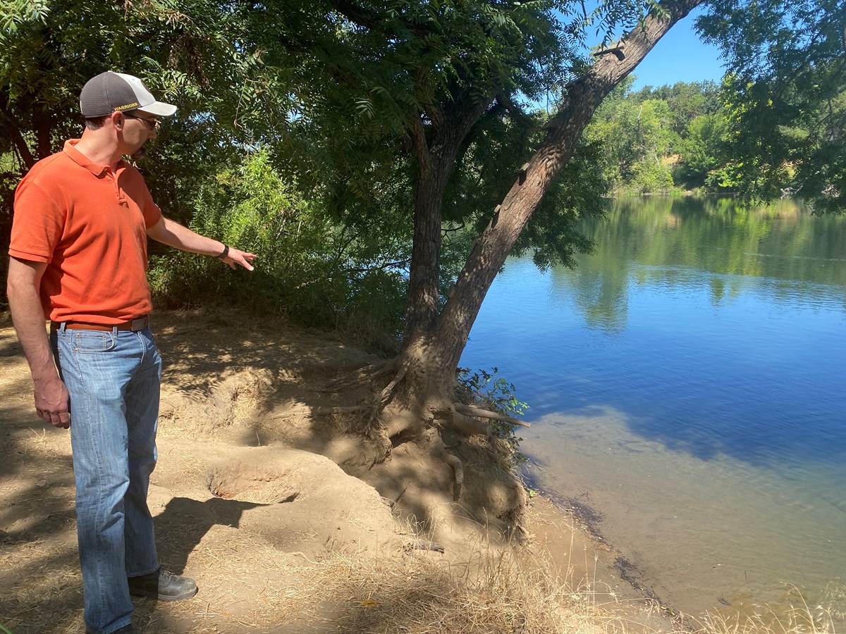 Hans Carota, one of the lead engineers on the proposed levee project points out erosion at a popular swimming hole on the south bank of the American River near Larchmont Park. June 17, 2025.Sally Longenecker/CapRadio
I don’t want to defend the Army Corps of Engineers for their choices on the trees. I’ve served on committees in the past that have looked at this… we felt it was overstated on the part of the Army Corps engineers to remove so many trees. The policy was “scorched earth,” they didn’t want a lick a vegetation anywhere on the levee because, for good reason, they were worried about a variety of things that can happen when you have trees on levees. Trees slow down the water; what you want is faster water. The big scary thing that people talk about is trees falling over and that root wad pulling a hole in the levee and causing [it] to fail. And then lots of vegetation on the levee is a problem. But of course, it’s this nature that makes it great for us in this area to go up and down the river.
Now, let me defend the Corps in that they are an engineering organization; they set engineering standards. All levees that are within these flood control systems, that are approved by the Corps, have to meet these national standards… even though the standards may not entirely make sense.
The Army Corps is also working to upgrade the Sacramento Weir, in what they call the first major upgrade in its over 100-year history. This seems like a pretty significant boost to local flood control.
One of the problems is that after the Gold Rush when the early version of the Army Corps came in, they basically squeezed the Sacramento River down to this very narrow channel compared to the volume that can flow in it. When everything is flowing strong, the amount of water that’s going down the Yolo Bypass is three or four times what’s going down the Sacramento River. So connecting the river to the bypass is absolutely essential; we would be wiped off the map on a regular basis if it were not for the two major weirs that push water out onto the Yolo Bypass.
The Sacramento Weir has been scary for a long time because it’s old, it was falling apart. It’s made of wood. One of the things that happens with weirs is they begin to erode around their edges at their abutments, and then the whole levee goes.
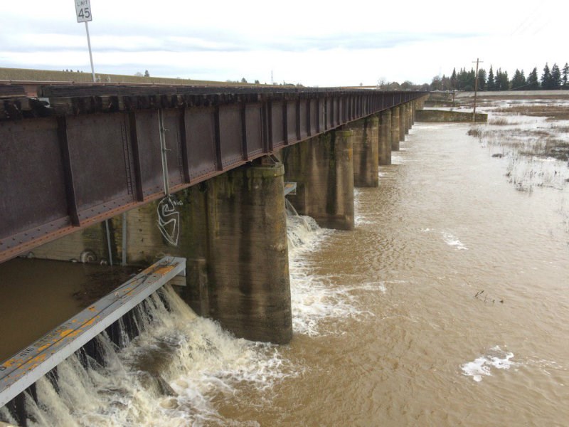 A photo of the Sacramento Weir on the morning of Jan. 9, 2017 with water splashing through.Bob Moffitt / Capital Public Radio
They’ve run into some problems, this is a surprise to no one. Until you start building these things you don’t know what the soils are. They’ve got some subsidence, they’ve got some technological challenges that are going to delay building the weir. And, if you’re building a big project like this… whenever they tell you what it’s going to be in the beginning, double the amount of time and double the cost. And that’s kind of actually played out here.