
Northern California forecast: Showers this week, stronger storm possible this weekend
Rain amounts will be light through Friday, but atmospheric river moisture could lead to big totals this weekend and beyond.
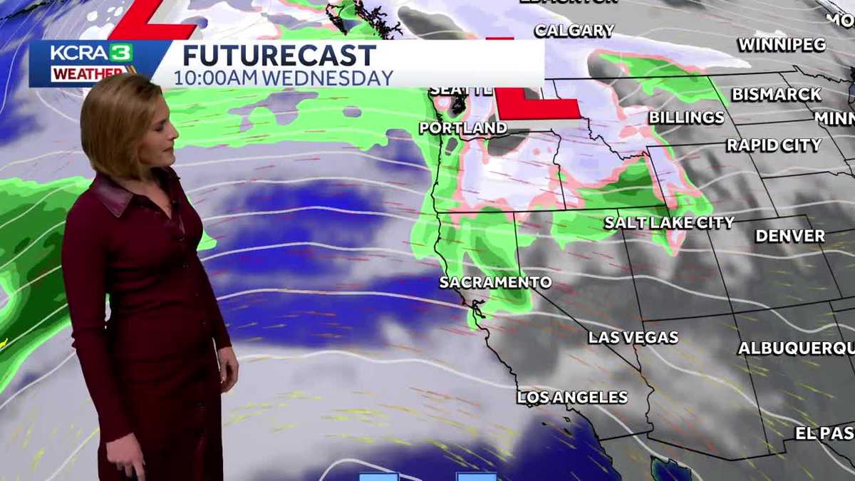
IT WOULD BE NICE TO GET A BREAK FROM ALL OF THIS. YEAH, I DO THINK THE VALLEY IS STILL GOING TO BE KIND OF GRAY AGAIN TOMORROW, BUT SOME OF US WILL AT LEAST GET A LITTLE BIT OF RAIN OUT OF THOSE CLOUDS ON TUESDAY. WE’VE GOT A LOT TO TALK ABOUT, SO WE’RE GOING TO GET RIGHT INTO IT HERE. CHANCE FOR SHOWERS FOR SOME TOMORROW, MAINLY TO THE NORTH OF INTERSTATE 80. THAT CHANCE IS A LITTLE BIT MORE WIDESPREAD ON WEDNESDAY. IT’S MAINLY DURING THE MORNING, THURSDAY AND FRIDAY. DRY DURING THE DAYLIGHT HOURS WITH SHOWERS POSSIBLE AS WE GET INTO LATER IN THE EVENING. NOW LOOKING AHEAD TO SUNDAY INTO MONDAY, THAT IS A SLIGHTLY BETTER CHANCE FOR SOME MORE WIDESPREAD RAIN, BUT LET’S FOCUS ON THE WORKWEEK FOR THE TIME BEING. THERE’S OUR FIRST LITTLE SYSTEM PASSING BY AGAIN, MAINLY TO THE NORTH. AS THAT DROPS TO THE SOUTH, WE SEE SHOWERS IN PARTS OF THE AREA AS WE GO THROUGH WEDNESDAY MORNING. THURSDAY, RIDGE TRIES TO FILL IN. THE QUESTION IS WHETHER OR NOT, WITH LESS WIND AND LESS RAIN, CHANCES THAT VALLEY FOG TRIES TO REFORM. THAT’S SOMETHING WE’RE GOING TO BE PAYING CLOSE ATTENTION TO. HERE COMES THAT NEXT CHANCE FOR SHOWERS. THIS IS 8:00 FRIDAY EVENING. SO ALL DAY THURSDAY ALL DAY FRIDAY IT’S LOOKING DRY. AND IT SHOULD BE AT LEAST A LITTLE BIT MILDER FOR THE VALLEY. NOW THROUGH FRIDAY, WE’RE NOT TALKING ABOUT A LOT OF RAIN. THESE ARE FOUR DAY RAINFALL TOTALS, LESS THAN A QUARTER OF AN INCH OF RAIN FOR THE SACRAMENTO VALLEY. LESS THAN A 10TH OF AN INCH OF RAIN FOR THE SAN JOAQUIN VALLEY. YOU GO UP INTO THE FOOTHILLS AS USUAL, NORTH OF INTERSTATE 80. WE HAVE THE POTENTIAL FOR A HALF AN INCH TO AN INCH OF RAIN, BUT AGAIN, THAT’S COMING OVER SEVERAL DIFFERENT ROUNDS, WHICH YOU WON’T SEE IS SNOW IN THE SIERRA. THESE NEXT FEW ROUNDS GOING THROUGH THE DAY ON FRIDAY HAVE LOTS OF WARM AIR. STILL, IT’S GOING TO BE STAYING MILD AT LAKE LEVEL. THERE WILL BE SOME GUSTY WINDS AROUND TAHOE TUESDAY NIGHT INTO WEDNESDAY, BUT WE’RE NOT EXPECTING SNOW, AT LEAST NOT THROUGH FRIDAY. AGAIN, REVISITING SATURDAY EVENING INTO SUNDAY AND MONDAY. THE POTENTIAL FOR A MORE WIDESPREAD RAIN EVENT. SO FRIDAY IT’S THOSE SHOWERS TO THE NORTH AND THE EVENING AS WE GO INTO SATURDAY, THOSE CHANCES FOR RAIN START TO FILL IN A LITTLE BIT BETTER. THEY HANG AROUND FOR SUNDAY, ESPECIALLY AREAS NORTH OF INTERSTATE 80, AND THEY POTENTIALLY HANG AROUND INTO MONDAY AS WELL. AS WE ZOOM THIS BACK, YOU CAN SEE THE MOISTURE FROM THE SYSTEM CONNECTS ALL THE WAY TO THE TROPICS. SO WEAK ATMOSPHERIC RIVER MOISTURE COULD BE TAPPED IN WITH THAT WEEKEND SYSTEM. BUT BECAUSE OF WHERE THAT MOISTURE IS COMING FROM THE TROPICS, THAT TELLS US THAT COULD POSSIBLY BE A WARMER SYSTEM AS WELL. SO NOT EXPECTING MUCH IN THE WAY OF SNOW WITH THAT ROUND. BUT THIS WEEKEND’S FORECAST SOMETHING TO WATCH. THINGS ARE GOING TO BE CHANGING OVER THE NEXT COUPLE OF DAYS. AS FOR TOMORROW, SHOWERS POSSIBLE FROM SOUTH LAKE TAHOE UP TO QUINCY. QUINCY’S WHERE WE’RE MOST LIKELY TO SEE ANY ACCUMULATING RAINFALL. TEMPERATURES STAYING IN THE 50S AROUND LAKE LEVEL IN THE SIERRA TOMORROW. GRASS VALLEY SHOWERS ON AND OFF THROUGH THE DAY TOMORROW. IT’S NOT A WASHOUT. IN GENERAL, THE FARTHER SOUTH YOU GO, THE DRIER IT’S GOING TO BE. TEMPERATURES WILL BE IN THE 60S AND ANGELS CAMP AND SONORA. CHANCES FOR SHOWERS FOR LAKEPORT, FOR NAPA AS WELL. BUT YOU GO SAN FRANCISCO SOUTHWARD. IT SHOULD BE STAYING DRY WITH MORE CLOUDS THAN SUN THROUGHOUT THE DAY. SAN JOAQUIN VALLEY, FOR BETTER OR WORSE, WE’RE NOT GOING TO CHANGE ANYTHING UP TOMORROW. STILL A LOT OF LOW CLOUD COVER TEMPERATURES LIKELY STILL STAYING IN THE 40S. THE SACRAMENTO VALLEY MAY GET A LITTLE BIT BRIGHTER LATER ON IN THE DAY, ESPECIALLY DAVIS VACAVILLE WOODLAN TEMPERATURES MAY PEAK IN THE LOWER 50S THERE, BUT STAYING IN THE 40S, I THINK FOR MOST OF THE DAY. FOR SACRAMENTO, THERE’S ANOTHER PEEK AT THAT SEVEN DAY FORECAST. AGAIN, WE’RE NOT TALKING ABOUT A LOT OF BLUE SKY FOR THE VALLEY. THAT’S NOT THE CHANGE WE’RE SEEING, BUT AT LEAST SOME CHANCES FOR SOME SHOWERS. BUT SUNDAY AND MONDAY, THOSE WILL BE THE DAYS TO PAY ATTENTION TO FOR BETTER RAIN. I FEEL LIKE IT WILL AT LEAST JUST CHANGE THINGS UP, MAYBE WHISK IT UP A LITTLE BIT. KIND OF. YEAH, IT’S A GOOD W
Northern California forecast: Showers this week, stronger storm possible this weekend
Rain amounts will be light through Friday, but atmospheric river moisture could lead to big totals this weekend and beyond.

Updated: 6:56 PM PST Dec 15, 2025
After nearly four weeks of stagnant weather, changes are finally here for Northern California. Scattered rain showers are possible north of Interstate 80 on Tuesday. Areas south of 80 will stay dry. Totals in the Valley will be less than a tenth of an inch. Foothills totals could be closer to a quarter inch. Tuesday’s system will be too warm for snow at the Sierra summits. Rain showers will drop south early Wednesday morning. Roads will be damp in the Foothills and Sierra for the Wednesday morning drive. Sprinkles are possible in the Valley, but many places will be dry during the daylight hours.Once again, snow is not expected at pass level on Wednesday.Thursday and Friday daylight hours look cloudy and dry for travel and any outdoor activities. Showers may return after sunset Friday evening. This weekend and Christmas weekMore impactful weather is expected in the days leading up to Christmas. Starting this weekend, a couple of storm systems have the potential to bring widespread precipitation to Northern California. The first could arrive late Saturday and linger into Monday. Another is possible around the middle of next week. Christmas eve is Wednesday.These systems will tap into moisture from an atmospheric river, creating the potential for heavier rainfall rates. The important thing to remember is that any shift in the direction of an atmospheric river storm can have a dramatic effect on expected rain and snow totals. As of Monday, Sunday looks like the wetter of the two weekend days. The KCRA 3 weather team will share more information on expected totals and snow levels later this week. See more coverage of top California stories here | Download our app | Subscribe to our morning newsletter | Find us on YouTube here and subscribe to our channel
SACRAMENTO, Calif. —
After nearly four weeks of stagnant weather, changes are finally here for Northern California.
Scattered rain showers are possible north of Interstate 80 on Tuesday. Areas south of 80 will stay dry. Totals in the Valley will be less than a tenth of an inch. Foothills totals could be closer to a quarter inch.
Tuesday’s system will be too warm for snow at the Sierra summits.
Rain showers will drop south early Wednesday morning. Roads will be damp in the Foothills and Sierra for the Wednesday morning drive. Sprinkles are possible in the Valley, but many places will be dry during the daylight hours.
Once again, snow is not expected at pass level on Wednesday.
Thursday and Friday daylight hours look cloudy and dry for travel and any outdoor activities. Showers may return after sunset Friday evening.
This weekend and Christmas week
More impactful weather is expected in the days leading up to Christmas.
Starting this weekend, a couple of storm systems have the potential to bring widespread precipitation to Northern California. The first could arrive late Saturday and linger into Monday. Another is possible around the middle of next week. Christmas eve is Wednesday.

Hearst Owned
Storm systems with atmospheric river moisture could impact Northern California this weekend and next week ahead of Christmas.
These systems will tap into moisture from an atmospheric river, creating the potential for heavier rainfall rates. The important thing to remember is that any shift in the direction of an atmospheric river storm can have a dramatic effect on expected rain and snow totals.
As of Monday, Sunday looks like the wetter of the two weekend days.
The KCRA 3 weather team will share more information on expected totals and snow levels later this week.
See more coverage of top California stories here | Download our app | Subscribe to our morning newsletter | Find us on YouTube here and subscribe to our channel