

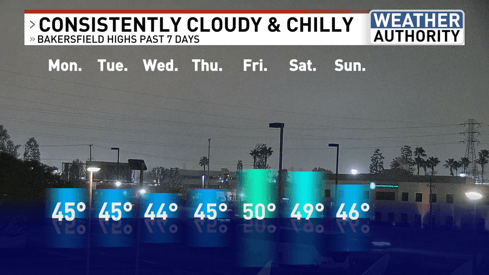
BAKERSFIELD, Calif. (KBAK/KBFX) — After more than a week of 40s, last Friday saw 50 in Bakersfield for the first time in nearly 189 hours! The sun came out across the largest part of the South Valley in quite a long time.
After more than a week of 40s, last Friday saw 50 in Bakersfield for the first time in nearly 189 hours! The sun came out across the largest part of the South Valley in quite a long time. PHOTO: KBAK/KBFX
The very next day, another attempt was made at clearing, but it stopped short of the previous day’s coverage. As such, 50 was missed by a degree. Sunday, came in even cooler again, with a high of only 46, and here we had Monday which was a carbon copy – temperature-wise!
After more than a week of 40s, last Friday saw 50 in Bakersfield for the first time in nearly 189 hours! The sun came out across the largest part of the South Valley in quite a long time. PHOTO: KBAK/KBFX
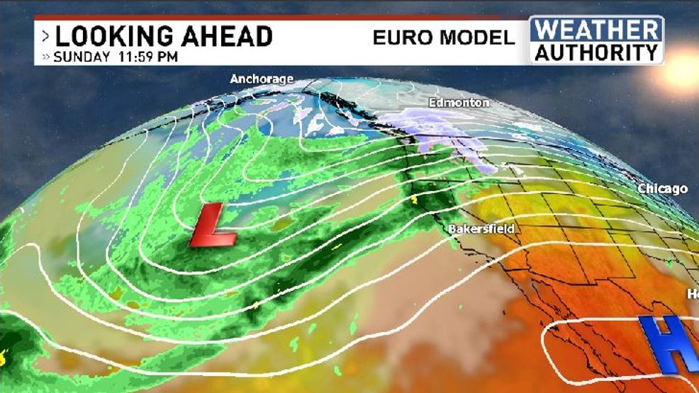
So, are we back to where we were last week? Another high is expected to nudge in from the Pacific, while a trough sets up a west to east flow into the Pacific Northwest for another Atmospheric River. Central California will be caught in-between. Could the Tule erode across northern California but still stay across southern parts of the Valley? Looks like more “wait and see as far as the Tule”.
THE EASIER FORECAST…
Lots of sun, along with periodic high clouds, and temperatures from the mid 60s to the low 70s are still in that forecast for the Kern River Valley, Desert and Kern County mountains this week. Breeziness will become more common by mid to late week as pressure gradients tighten but all-in-all these areas have the easier forecast.
BIG PATTERN CHANGE COMING INTO FOCUS:
After several weeks of status-quo an atmospheric rearrangement appears to be agreed upon by most of the medium-to-long-range computer models. Next week the general consensus is on a southbound trough building across the northeast Pacific, being carved out from Alaska southwest across the ocean about halfway between Hawaii and LA.
After more than a week of 40s, last Friday saw 50 in Bakersfield for the first time in nearly 189 hours! The sun came out across the largest part of the South Valley in quite a long time. PHOTO: KBAK/KBFX
If this were to pan out it would bring the first opportunity for widespread precipitation to southcentral California that we’ve seen since last month. As a reminder – there have been episodes of mist, drizzle and even light rain from the Tule clouds in recent days/weeks but this would be due to actual storm systems. At this time this could be within the 10-day window, so it’s certainly something worth monitoring, for now.
Comment with Bubbles
BE THE FIRST TO COMMENT
Have a great new week!