
Northern California forecast: Rain chances begin today
Cloudy and cool with areas of drizzle and mist again this morning, but rain chances increase throughout the day and gusty winds arrive in the Sierra tonight.
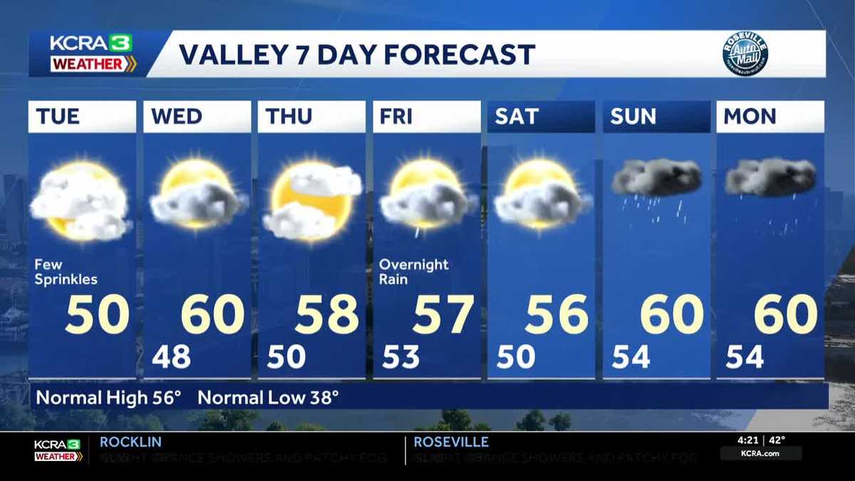
COMMENTS FOR 19. SWITCHING BACK TO OUR FORECAST AS WE TAKE A LIVE LOOK HERE OVER DOWNTOWN SACRAMENTO. SEND IT OVER TO METEOROLOGIST TAMARA BERG. YEAH, AND YOU CAN STILL SEE THE HAZY SKIES OUT THERE. AT LEAST THINGS ARE RATHER ELEVATED. I’M NOT SEEING ANY BIG, SHARP, SUDDEN DROPS IN VISIBILITY. IF YOU’RE AN EARLY RISER, TACKLING THAT TUESDAY MORNING COMMUTE. LIVE. LOOK RIGHT NOW FROM STOCKTON IN VENICE SOUTH ARENA. SKY CAMERA SHOWING OFF THOSE HAZY SKIES AROUND DOWNTOWN. TEMPERATURES RIGHT NOW. LOWER 40S. IT’S 27 RIGHT NOW, WAKING UP IN SOUTH LAKE TAHOE. AND AGAIN, MOST OF THE VISIBILITY PARAMETERS ARE PRETTY MUCH AT OR ABOVE A MILE. THE ONLY CAVEAT HERE IS FAIRFIELD DOWN TO ABOUT A HALF MILE AT TRAVIS AIR FORCE BASE. SO THERE WILL BE SOME STICKIER AREAS OUT THERE WITH SOME HEAVIER POCKETS OF FOG. IF YOU’RE COMMUTING AROUND PARTS OF SOLANO COUNTY, SACRAMENTO STOCKTON AREA OFF TOWARDS MODESTO. AGAIN, EVERYTHING IS JUST RELATIVELY HAZY. I’M ALSO WATCHING NOT ONLY THE LOW CLOUDS THAT HAVE BEEN REALLY ALONG THE VALLEY FOR THE PAST COUPLE OF WEEKS, SOME HIGH CLOUDS MARCHING IN WITH THIS SYSTEM. THAT’S A PIECE OF MOISTURE THAT’S PUSHING THROUGH WITH A COUPLE OF SHOWERS. NOW, THIS SYSTEM WILL ROTATE THROUGH THE AREA TODAY. MAY PRODUCE A BRIEF SHOWER FOR THE MORNING COMMUTE, EVEN INTO THE AFTERNOON HOURS. I’M JUST NOT EXPECTING THAT. IT’S GOING TO BRING US A LOT OF RAINFALL. IN FACT, WHEN YOU LOOK AT THE RAINFALL, LOOKING AHEAD TO TONIGHT AGAIN, A FEW ONE HUNDREDTHS OF AN INCH POSSIBLE, MAYBE. PROBABLY NOT GOING TO SEE MUCH IN THE BUCKET. IF ANYTHING, STOCKTON AND MODESTO MAY SEE UPWARDS OF A 10TH OF AN INCH IN AREAS, ESPECIALLY ALONG AND NORTH OF I-80. AND THEN RUNNING THIS THROUGH AS WE GET INTO WEDNESDAY AFTERNOON. BETTER CHANCE WE SEE A LITTLE BIT MORE RAINFALL MEASURE UP IN THE BUCKET. BUT EVEN AT THAT, WE’RE STILL TALKING UNDER A 10TH OF AN INCH IN SACRAMENTO. SOME HEAVIER AMOUNTS ALONG THE COAST RANGE AND UP TOWARDS MOUNT SHASTA, AND THEN EVEN AREAS OF THE WEST SLOPE LIKE AUBURN ARE PLACERVILLE MAY SQUEEZE OUT OVER A HALF AN INCH WITH THE PASSING SYSTEM TOMORROW. HERE’S TUESDAY QUEUED UP FUTURECAST 9:00 IN THE MORNING. FEW OF THOSE PASSING SPRINKLES OR SHOWERS. AND THEN A BETTER CHANCE WE SEE POTENTIAL. MORE FEW SHOWERS IN THE AFTERNOON. AND THEN GETTING INTO WEDNESDAY. THERE’S WHERE WE START TO SQUEEZE OUT THE BETTER. RAINFALL RETURNS AT 6 A.M. FOR WEDNESDAY MORNING. RIGHT DOWN THE WEST SLOPE. IT’S GOING TO BE ALL RAIN. I DON’T ANTICIPATE SNOW UNLESS YOU’RE ABOVE ABOUT 8500FT. TOMORROW WE GET INTO THE DAYTIME ON THURSDAY. THURSDAY IS GOING TO BE A DRY DAY, AND WE MAY EVEN SEE MORE DEVELOPMENT OF THE FOG AND THE STRATUS DECK IN THE VALLEY THURSDAY MORNING. SOMETHING WE’LL KEEP AN EYE ON AND THEN PUSHING AHEAD INTO THE FRIDAY FORECAST. FRIDAY ALSO LOOKS RELATIVELY DRY, ESPECIALLY DURING THE DAYLIGHT HOURS, WITH RAIN DEVELOPING OVERNIGHT AND INTO THE DAY ON SATURDAY. BUT EVEN SATURDAY TO THAT DEGREE, THE SHOWERS WILL BE MORE KIND OF HIT AND MISS. AND ON THE LIGHTER SCALE, IT’S NOT UNTIL SUNDAY TEO INTO MONDAY THAT WE SEE A BETTER CHANCE FOR A BETTER, STRONGER SYSTEM THAT HOLDS WITH MORE RAINFALL POSSIBLE DURING THE DAY SUNDAY AND AGAIN ON MONDAY, AND RETURN CHANCES ALL THROUGH NEXT WEEK. SO I KNOW NEXT WEEK IS A BIG TRAVEL WEEK FOR A LOT OF FOLKS. WE’VE GOT A ARTICLES UPDATED ON OUR WEBSITE AND WE KEEP YOU POSTED EACH DAY WITH THE CHANGES TO THE FORECAST, BUT KEEP AN EYE ON B
Northern California forecast: Rain chances begin today
Cloudy and cool with areas of drizzle and mist again this morning, but rain chances increase throughout the day and gusty winds arrive in the Sierra tonight.

Updated: 5:15 AM PST Dec 16, 2025
Cloudy and cool conditions are present in the Valley again this morning with areas of mist and drizzle. Visibility will be reduced in the Valley and Foothills for the morning commute, be sure to have your headlights on. A weak disturbance brushes by to the North today and will trigger some scattered showers, mainly along and north of I-80. Little to no measurable rainfall expected today.Another wave of moisture moves through early Wednesday morning, with the Foothills and the Sierra seeing the bulk of the precipitation. Some Valley locations may see up to 0.10″, but portions of the Foothills and Sierra could receive up to 0.75″ of rainfall by Wednesday evening. Gusty winds develop tonight in the Sierra out of the SW at 2-30 mph with gusts up to 45 mph in the Valley and up to 100 mph along the crest. 2-4 ft waves are expected on Lake Tahoe. A Wind Advisory is in place for the Sierra from 10:00 pm Tuesday through 4:00 pm Wednesday. Thursday is expected to be dry, but with clouds and fog.Rain chances increase Friday night and into the weekend with the best chances for Sierra snow coming early next week.
SACRAMENTO, Calif. —
Cloudy and cool conditions are present in the Valley again this morning with areas of mist and drizzle. Visibility will be reduced in the Valley and Foothills for the morning commute, be sure to have your headlights on.
A weak disturbance brushes by to the North today and will trigger some scattered showers, mainly along and north of I-80. Little to no measurable rainfall expected today.
Another wave of moisture moves through early Wednesday morning, with the Foothills and the Sierra seeing the bulk of the precipitation. Some Valley locations may see up to 0.10″, but portions of the Foothills and Sierra could receive up to 0.75″ of rainfall by Wednesday evening.
Gusty winds develop tonight in the Sierra out of the SW at 2-30 mph with gusts up to 45 mph in the Valley and up to 100 mph along the crest. 2-4 ft waves are expected on Lake Tahoe. A Wind Advisory is in place for the Sierra from 10:00 pm Tuesday through 4:00 pm Wednesday.
Thursday is expected to be dry, but with clouds and fog.
Rain chances increase Friday night and into the weekend with the best chances for Sierra snow coming early next week.