
Several rounds of heavy rain are in the forecast for Northern California as storm systems send atmospheric river moisture into the region over the next seven days. Ahead of the rain, the National Weather Service office in Sacramento and Reno issued Flood Watches that cover the Valley, Foothills and Sierra. The Flood Watch will be in effect from Saturday afternoon through next Friday, Dec. 26. It’s important to note that widespread flooding is not expected during that entire stretch. Here’s a breakdown of what to expect:Street and urban floodingThis is the most likely type of flooding that we’ll see, and it could start as early as Sunday. Intersections, roads and grassy areas that don’t drain well will have standing water at times. Remember: if you come to a flooded road, do not try to drive through. You can never be certain if the road underneath is still passable and even a few inches of water could cause major problems for smaller vehicles.Creek floodingDry weather in recent weeks means we’re starting this wet stretch with plenty of room in the ground and in our waterways for runoff. This will prevent creek flooding Saturday, Sunday and possibly Monday evening in the Valley. Foothills creeks and streams that normally run dry will be flowing fast these days.A lull in heavy rain on Tuesday will allow creeks to recede a little. There is an increased chance for minor creek and stream flooding as heavy rain returns Tuesday night into Thursday. If you live near a creek and you’ve experienced minor flooding before, take steps to get your property ready over the next few days.Sacramento County creek levels can be checked here.River floodingMainstem rivers that are regulated by dams and reservoirs will not flood during this stretch of wet weather. Folsom Lake, Lake Oroville, Shasta and other major dams have plenty of room for runoff and water managers will make releases as needed to regulate water levels in the Sacramento, lower American, Feather and Yuba rivers.Uncontrolled rivers, including the Cosumnes River, are not expected to flood through Tuesday. There is a chance that minor flooding may occur towards the end of next week, but flooding is not expected to be as severe as what many experienced around New Year’s in 2023-24.REAL-TIME TRAFFIC MAPClick here to see our interactive traffic map.TRACK INTERACTIVE, DOPPLER RADARClick here to see our interactive radar.DOWNLOAD OUR APP FOR THE LATESTHere is where you can download our app.Follow our KCRA weather team on social mediaMeteorologist Tamara Berg on Facebook and X.Meteorologist Dirk Verdoorn on FacebookMeteorologist/Climate Reporter Heather Waldman on Facebook and X.Meteorologist Kelly Curran on X.Meteorologist Ophelia Young on Facebook and X.Watch our forecasts on TV or onlineHere’s where to find our latest video forecast. You can also watch a livestream of our latest newscast here. The banner on our website turns red when we’re live.We’re also streaming on the Very Local app for Roku, Apple TV or Amazon Fire TV.
Several rounds of heavy rain are in the forecast for Northern California as storm systems send atmospheric river moisture into the region over the next seven days.
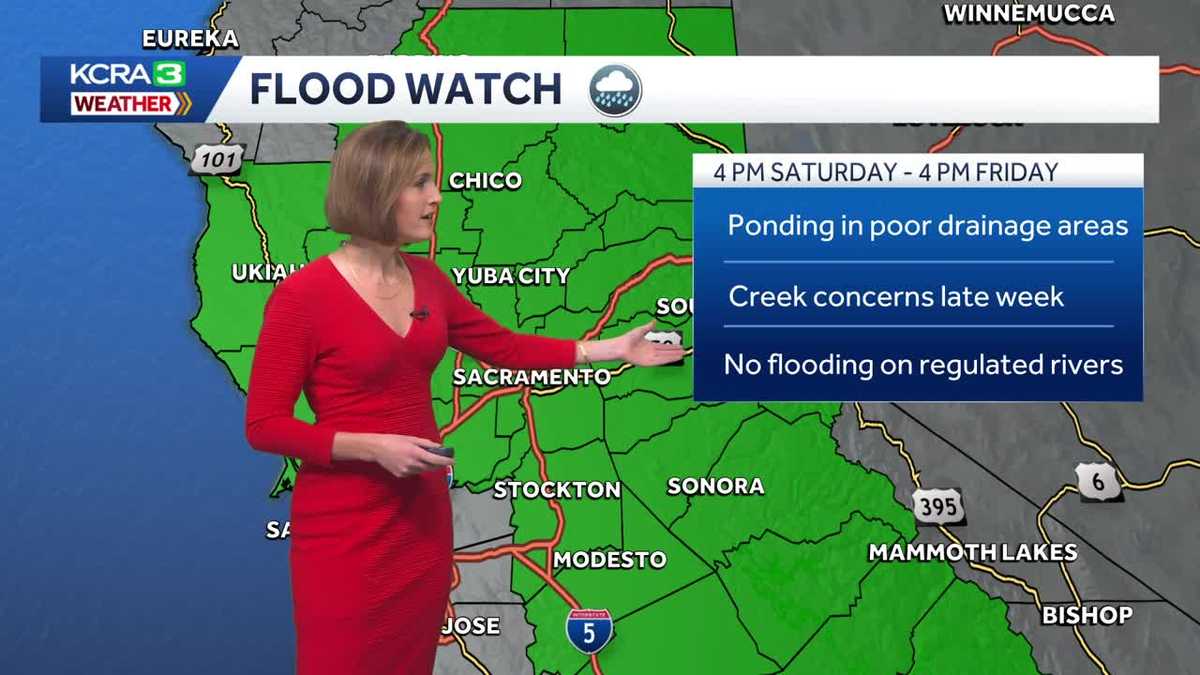
Ahead of the rain, the National Weather Service office in Sacramento and Reno issued Flood Watches that cover the Valley, Foothills and Sierra. The Flood Watch will be in effect from Saturday afternoon through next Friday, Dec. 26.
It’s important to note that widespread flooding is not expected during that entire stretch. Here’s a breakdown of what to expect:
Street and urban flooding
This is the most likely type of flooding that we’ll see, and it could start as early as Sunday.
Intersections, roads and grassy areas that don’t drain well will have standing water at times.
Remember: if you come to a flooded road, do not try to drive through. You can never be certain if the road underneath is still passable and even a few inches of water could cause major problems for smaller vehicles.
Creek flooding
Dry weather in recent weeks means we’re starting this wet stretch with plenty of room in the ground and in our waterways for runoff. This will prevent creek flooding Saturday, Sunday and possibly Monday evening in the Valley.
Foothills creeks and streams that normally run dry will be flowing fast these days.
A lull in heavy rain on Tuesday will allow creeks to recede a little.
There is an increased chance for minor creek and stream flooding as heavy rain returns Tuesday night into Thursday. If you live near a creek and you’ve experienced minor flooding before, take steps to get your property ready over the next few days.
Sacramento County creek levels can be checked here.
River flooding
Mainstem rivers that are regulated by dams and reservoirs will not flood during this stretch of wet weather.
Folsom Lake, Lake Oroville, Shasta and other major dams have plenty of room for runoff and water managers will make releases as needed to regulate water levels in the Sacramento, lower American, Feather and Yuba rivers.
Uncontrolled rivers, including the Cosumnes River, are not expected to flood through Tuesday. There is a chance that minor flooding may occur towards the end of next week, but flooding is not expected to be as severe as what many experienced around New Year’s in 2023-24.
REAL-TIME TRAFFIC MAP
Click here to see our interactive traffic map.
TRACK INTERACTIVE, DOPPLER RADAR
Click here to see our interactive radar.
DOWNLOAD OUR APP FOR THE LATEST
Here is where you can download our app.
Follow our KCRA weather team on social media
Meteorologist Tamara Berg on Facebook and X.Meteorologist Dirk Verdoorn on FacebookMeteorologist/Climate Reporter Heather Waldman on Facebook and X.Meteorologist Kelly Curran on X.Meteorologist Ophelia Young on Facebook and X.
Watch our forecasts on TV or online
Here’s where to find our latest video forecast. You can also watch a livestream of our latest newscast here. The banner on our website turns red when we’re live.
We’re also streaming on the Very Local app for Roku, Apple TV or Amazon Fire TV.