
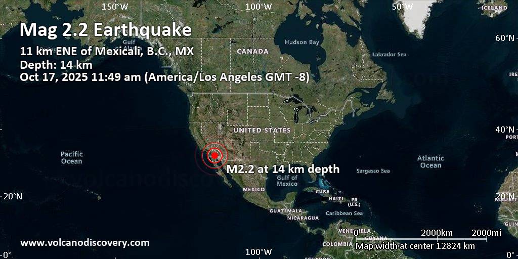
Date and Time Mag
Mag
DepthDistanceLocationDetailsMap
Oct 16, 04:50 am (Los Angeles)
2.5
8.8 km76 km (47 mi) to the NW![]() 10 km SE of Ocotillo Wells, CA 1 report
10 km SE of Ocotillo Wells, CA 1 report
Info
Oct 12, 01:35 am (Tijuana)
3.2
20 km61 km (38 mi) to the SW![]() 49 km southwest of Mexicali, Estado de Baja California, Mexico I FELT IT – 1 report
49 km southwest of Mexicali, Estado de Baja California, Mexico I FELT IT – 1 report
Info
Oct 11, 09:03 pm (Tijuana)
2.3
0.7 km39 km (24 mi) to the SW![]() 27 km southwest of Mexicali, Estado de Baja California, Mexico
27 km southwest of Mexicali, Estado de Baja California, Mexico
Info
Oct 10, 05:13 pm (Tijuana)
2.3
10.4 km38 km (24 mi) to the S![]() 5 km NW of Delta, B.C., MX
5 km NW of Delta, B.C., MX
Info
Oct 9, 04:30 am (Los Angeles)
2.5
11 km36 km (22 mi) to the NW![]() 5 km W of Brawley, CA 1 report
5 km W of Brawley, CA 1 report
Info
Aug 26, 2012 01:57 pm (Los Angeles)
5.4
8.3 km38 km (24 mi) to the NW![]() 2.8 mi north of Brawley, Imperial County, California, United States InfoAug 26, 2012 12:31 pm (Los Angeles)
2.8 mi north of Brawley, Imperial County, California, United States InfoAug 26, 2012 12:31 pm (Los Angeles)
5.3
8.3 km39 km (24 mi) to the NW![]() 3 mi northwest of Brawley, Imperial County, California, United States 1 reportInfoJun 14, 2010 09:26 pm (Los Angeles)
3 mi northwest of Brawley, Imperial County, California, United States 1 reportInfoJun 14, 2010 09:26 pm (Los Angeles)
5.7
8.8 km51 km (32 mi) to the W![]() 5.4 mi southeast of Ocotillo, Imperial County, California, United States InfoApr 4, 2010 04:25 pm (Tijuana)
5.4 mi southeast of Ocotillo, Imperial County, California, United States InfoApr 4, 2010 04:25 pm (Tijuana)
5.3
10 km50 km (31 mi) to the S![]() 2.3 km northwest of Cucapah Mestizo, Estado de Baja California, Mexico InfoApr 4, 2010 04:15 pm (Tijuana)
2.3 km northwest of Cucapah Mestizo, Estado de Baja California, Mexico InfoApr 4, 2010 04:15 pm (Tijuana)
5.4
10 km46 km (29 mi) to the S![]() Estado de Baja California, Mexico InfoApr 4, 2010 03:50 pm (Tijuana)
Estado de Baja California, Mexico InfoApr 4, 2010 03:50 pm (Tijuana)
5.7
10 km74 km (46 mi) to the SE![]() 11 km southwest of Estacion Coahuila, Estado de Baja California, Mexico InfoApr 4, 2010 03:40 pm (Tijuana)
11 km southwest of Estacion Coahuila, Estado de Baja California, Mexico InfoApr 4, 2010 03:40 pm (Tijuana)
7.2
10 km47 km (29 mi) to the S![]() The 2010 Sierra El Mayor, B.C., Mexico Earthquake InfoDec 30, 2009 11:48 am (Tijuana)
The 2010 Sierra El Mayor, B.C., Mexico Earthquake InfoDec 30, 2009 11:48 am (Tijuana)
5.8
6 km32 km (20 mi) to the SE![]() 7.9 km west of Familia Corona, Estado de Baja California, Mexico InfoSep 13, 2006 05:11 pm (Los Angeles)
7.9 km west of Familia Corona, Estado de Baja California, Mexico InfoSep 13, 2006 05:11 pm (Los Angeles)
5.4
2.8 km66 km (41 mi) to the W![]() Calif.-Baja Calif. Border Region InfoMay 23, 2006 09:20 pm (Tijuana)
Calif.-Baja Calif. Border Region InfoMay 23, 2006 09:20 pm (Tijuana)
5.3
6 km46 km (29 mi) to the S![]() Estado de Baja California, Mexico InfoMay 20, 2005 05:39 pm (Los Angeles)
Estado de Baja California, Mexico InfoMay 20, 2005 05:39 pm (Los Angeles)
5.5
14 km94 km (58 mi) to the NW![]() San Diego County, 30 mi south of Coachella, Riverside County, California, United States InfoFeb 22, 2002 12:32 pm (Tijuana)
San Diego County, 30 mi south of Coachella, Riverside County, California, United States InfoFeb 22, 2002 12:32 pm (Tijuana)
5.7
7 km43 km (27 mi) to the S![]() Estado de Baja California, 54 km west of San Luis Rio Colorado, Mexico InfoDec 8, 2001 04:36 pm (Tijuana)
Estado de Baja California, 54 km west of San Luis Rio Colorado, Mexico InfoDec 8, 2001 04:36 pm (Tijuana)
5.7
7 km86 km (54 mi) to the SE![]() Estado de Baja California, 55 km southwest of San Luis Rio Colorado, Mexico InfoOct 16, 1999 02:46 am (Los Angeles)
Estado de Baja California, 55 km southwest of San Luis Rio Colorado, Mexico InfoOct 16, 1999 02:46 am (Los Angeles)
7.1
14 km227 km (141 mi) to the N![]() 59 mi east of Victorville, San Bernardino County, California, United States InfoJun 28, 1992 04:57 am (Los Angeles)
59 mi east of Victorville, San Bernardino County, California, United States InfoJun 28, 1992 04:57 am (Los Angeles)
7.3
-0.1 km193 km (120 mi) to the NW![]() 6 mi north of Yucca Valley, San Bernardino County, California, United States InfoNov 24, 1987 06:15 am (Los Angeles)
6 mi north of Yucca Valley, San Bernardino County, California, United States InfoNov 24, 1987 06:15 am (Los Angeles)
6.6
11 km57 km (35 mi) to the NW![]() 23 mi northwest of El Centro, Imperial County, California, United States InfoNov 23, 1987 06:54 pm (Los Angeles)
23 mi northwest of El Centro, Imperial County, California, United States InfoNov 23, 1987 06:54 pm (Los Angeles)
6.2
10.9 km58 km (36 mi) to the NW![]() 25 mi northwest of El Centro, Imperial County, California, United States InfoFeb 6, 1987 08:45 pm (Tijuana)
25 mi northwest of El Centro, Imperial County, California, United States InfoFeb 6, 1987 08:45 pm (Tijuana)
5.3
6 km36 km (22 mi) to the S![]() 30 km southeast of Mexicali, Estado de Baja California, Mexico InfoApr 26, 1981 05:09 am (Los Angeles)
30 km southeast of Mexicali, Estado de Baja California, Mexico InfoApr 26, 1981 05:09 am (Los Angeles)
5.7
19 km49 km (31 mi) to the NW![]() 21 mi north of El Centro, Imperial County, California, United States InfoJun 8, 1980 08:28 pm (Tijuana)
21 mi north of El Centro, Imperial County, California, United States InfoJun 8, 1980 08:28 pm (Tijuana)
6.3
6 km61 km (38 mi) to the SE![]() 5km SE of Alberto Oviedo Mota, B.C., MX InfoOct 15, 1979 11:58 pm (Los Angeles)
5km SE of Alberto Oviedo Mota, B.C., MX InfoOct 15, 1979 11:58 pm (Los Angeles)
5.8
14 km37 km (23 mi) to the NW![]() 3km NW of Brawley, CA InfoOct 15, 1979 04:16 pm (Tijuana)
3km NW of Brawley, CA InfoOct 15, 1979 04:16 pm (Tijuana)
6.4
15 km4.5 km (2.8 mi) to the S![]() 9.9 km northeast of Mexicali, Estado de Baja California, Mexico InfoApr 8, 1968 07:28 pm (Los Angeles)
9.9 km northeast of Mexicali, Estado de Baja California, Mexico InfoApr 8, 1968 07:28 pm (Los Angeles)
6.6
10 km86 km (54 mi) to the NW![]() San Diego County, 12 mi southwest of Salton City, Imperial County, California, United States InfoMar 19, 1954 02:54 am (Los Angeles)
San Diego County, 12 mi southwest of Salton City, Imperial County, California, United States InfoMar 19, 1954 02:54 am (Los Angeles)
6.4
6 km93 km (58 mi) to the NW![]() San Diego County, 7.2 mi west of Salton City, Imperial County, California, United States InfoOct 21, 1942 04:22 pm (Universal Time)
San Diego County, 7.2 mi west of Salton City, Imperial County, California, United States InfoOct 21, 1942 04:22 pm (Universal Time)
6.6
6 km49 km (31 mi) to the NW![]() 17km WSW of Westmorland, CA (USA) InfoMay 19, 1940 04:36 am (Universal Time)
17km WSW of Westmorland, CA (USA) InfoMay 19, 1940 04:36 am (Universal Time)
6.9
6 km15 km (9.5 mi) to the N![]() The 1940 Imperial Valley, California Earthquake InfoDec 31, 1934 06:45 pm (Universal Time)
The 1940 Imperial Valley, California Earthquake InfoDec 31, 1934 06:45 pm (Universal Time)
6.4
6 km61 km (38 mi) to the S![]() 5.4 km south of Doctor Alberto Oviedo Mota, Estado de Baja California, Mexico InfoDec 30, 1934 04:00 pm (Tijuana)
5.4 km south of Doctor Alberto Oviedo Mota, Estado de Baja California, Mexico InfoDec 30, 1934 04:00 pm (Tijuana)
7.1
0 km102 km (63 mi) to the S![]() Mexico: California: Baja, Imperial Valley InfoDec 30, 1934 01:52 pm (Universal Time)
Mexico: California: Baja, Imperial Valley InfoDec 30, 1934 01:52 pm (Universal Time)
6.3
6 km90 km (56 mi) to the SE![]() 24km SSE of Estacion Coahuila, B.C., MX InfoJan 1, 1927 09:13 am (Universal Time)
24km SSE of Estacion Coahuila, B.C., MX InfoJan 1, 1927 09:13 am (Universal Time)
6.0
10 km72 km (45 mi) to the SW![]() Baja California, Mexico InfoNov 21, 1915 12:13 am (Universal Time)
Baja California, Mexico InfoNov 21, 1915 12:13 am (Universal Time)
6.5
10 km95 km (59 mi) to the SE![]() 61 km south of San Luis Rio Colorado, Estado de Sonora, Mexico InfoJun 23, 1915 03:59 am (Universal Time)
61 km south of San Luis Rio Colorado, Estado de Sonora, Mexico InfoJun 23, 1915 03:59 am (Universal Time)
6.0
0 km16 km (10 mi) to the NW![]() 3.7 mi east of El Centro, Imperial County, California, United States InfoApr 19, 1906 12:30 am (Universal Time)
3.7 mi east of El Centro, Imperial County, California, United States InfoApr 19, 1906 12:30 am (Universal Time)
6.2
0 km25 km (15 mi) to the NW![]() 5.7 mi south of Brawley, Imperial County, California, United States Info
5.7 mi south of Brawley, Imperial County, California, United States Info