
MAPS: How to track Doppler radar, traffic and rain totals for California storm
Follow the storm with interactive radar and see the latest traffic conditions and rain totals.
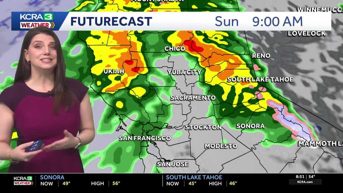
QUIETEST WEATHER WE’RE GOING TO HAVE FOR THE NEXT SEVERAL DAYS. SO IF YOU HAVE SOME ERRANDS TO RUN, THIS MORNING IS A REALLY GOOD TIME TO DO THAT. THIS IS ALSO A GREAT TIME TO START PREPARING FOR THE STORM. CLEAN OUT THE STORM DRAINS, GET ALL THOSE LEAVES AWAY FROM IT, RAKE UP AND BAG ANY LEAVES THAT YOU HAVE AROUND. BECAUSE OF COURSE, ONCE THAT RAIN STARTS, THOSE JUST GET SOGGY AND WET AND VERY SLICK. ALSO, SECURING ANY HOLIDAY DECORATIONS. THAT’S GOING TO BE A GOOD IDEA HERE OVER THE NEXT COUPLE OF DAYS AS WE TAKE A LOOK AT THE RADAR. MOSTLY CLOUDY SKIES, WE DO HAVE A FEW SCATTERED SHOWERS. MORE OF THOSE DEVELOPING HERE CLOSER TO THE COAST, A FEW SOUTH OF MODESTO AS WELL. NOW AS WE TAKE A LOOK AT FUTURECAST, I WANT YOU TO NOTICE THIS AREA OF WET WEATHER RIGHT HERE. THIS IS WHAT’S GOING TO BE MOVING IN AS WE GET INTO THE AFTERNOON AND EVENING HOURS. THAT RAIN IS GOING TO GET HEAVIER OVERNIGHT. AND THEN AS WE GET INTO TOMORROW, WE’RE TALKING ABOUT AN IMPACT DAY FOR MODERATE TO HEAVY RAINFALL. AS YOU HEAD FURTHER SOUTH IN THE SIERRA YOU’LL SEE A LITTLE BIT MORE SNOW, BUT AT LEAST INITIALLY, THOSE SNOW LEVELS ARE GOING TO BE PRETTY HIGH UP AROUND 8000FT. MONDAY IS GOING TO BE AN IMPACT DAY FOR US TO TUESDAY. JUST SOME RAIN SHOWERS AROUND, BUT THEN WEDNESDAY AND THURSDAY. NOW WE’RE TALKING ABOUT NOT JUST AN IMPACT DAY. WE’RE GOING TO STEP ABOVE THAT. WE’RE GOING FOR ALERT DAYS BECAUSE NOT ONLY ARE WE GOING TO BE DEALING WITH HEAVY RAIN, WE’RE GOING TO BE DEALING WITH GUSTY WINDS. AND THIS IS WHEN THE SIGNIFICANT SNOWFALL IS GOING TO START IN THE SIERRA. THAT CONTINUES INTO CHRISTMAS DAY. DON’T WORRY, I WON’T HAVE ANY PROBLEMS WITH SAINT NICHOLAS SLED THERE. FRIDAY, ANOTHER IMPACT DAY FOR RAIN AND SNOW. WE’LL CERTAINLY HAVE SOME TRAVEL HEADACHES IN THE SIERRA HERE OVER THE NEXT COUPLE OF DAYS, BUT THE SKI RESORTS WILL. ABOUT ALL THAT SNOW. NOW WE DO HAVE A FLOOD WATCH IN PLACE. IT BEGINS THIS AFTERNOON. GOES THROUGH FRIDAY AFTERNOON FOR EVERYBODY IN THE GREEN. WE’RE TALKING ABOUT SOME PONDING AND POOR DRAINAGE AREAS. AGAIN, THIS IS WHY IT’S SO IMPORTANT TO CLEAN OUT THOSE STORM DRAINS. NOW WE MAY SEE SOME FLOODING IN CREEKS, BUT ALL THE REGULATED RIVERS, THOSE SHOULD BE FINE. HOW MUCH RAINFALL ARE WE TALKING ABOUT? WELL, POTENTIALLY UP TO 15IN AROUND BLUE CANYON. PLACERVILLE UP TO TEN. 2 TO 4IN OF RAIN IN THE IN THE VALLEY HERE. AND THIS IS GENERALLY FOR SUNDAY AND FOR MONDAY NOW SNOWFALL. NOW THIS IS TUESDAY THROUGH FRIDAY. IT’S A LITTLE BIT LATER. THE SNOW LEVELS ARE GOING TO BE PRETTY HIGH TO START, BUT THEY DROP LATER IN THE WEEK. WE’RE GOING TO BE MEASURING THE SNOW IN FEET, NOT INCHES. SO DONNER SUMMIT AND ECHO SUMMIT, WE’RE TALKING UP TO SIX FEET OF SNOW. SONORA PASS COULD PICK UP 8 TO 10FT. LIKE I SAID, THOSE SKI RESORTS ARE GOING TO BE THRILLED WITH THIS STORM SYSTEM. NOW LET’S TALK ABOUT THE SEVEN DAY FORECAST. AND YOU CAN SEE A LOT OF COLORS HERE. THE YELLOW THOSE ARE THE IMPACT DAYS SUNDAY AND MONDAY. AND THEN AGAIN ON FRIDAY. ALERT DAYS ARE WEDNESDAY AND THURSDAY. THAT IS GOING TO CAUSE SOME TRAVEL PROBLEMS FOR THE HOLIDAYS. WE’RE GOING TO HAVE RAIN, GUSTY WINDS. AND THEN OF COURSE, WHEN WE’RE TALKING ABOUT FEET OF SNOW IN THE SIERRA, THAT’S WHEN WE JUST DON’T EVEN BOTHER. LIKE THE CHAIN CONTROLS OF COURSE WILL BE IN PLACE, BUT IT’S GOING TO BE REALLY HARD TRAVELING UP THERE EXCEPT FOR SANTA. HE’LL BE IN HIS ELE
Meteorologist/Climate Reporter
KCRA 3’s weather team issued Impact Days for Sunday and Monday because of how wet and breezy conditions will affect outdoor activities and travel for the Valley, Foothills and Sierra. The Sierra will see mainly rain through Tuesday.Wednesday and Thursday are now weather Alert Days. A strong storm with heavy rain, high winds and heavy snow will significantly impact plans for Christmas Eve and Christmas Day. Sierra travel is not recommended on these days. On the other hand, those in the area can expect a white Christmas. Ahead of the rain, the National Weather Service office in Sacramento and Reno issued Flood Watches that cover the Valley, Foothills and Sierra. The Flood Watch will be in effect from Saturday afternoon through next Friday, Dec. 26. It’s important to note that widespread flooding is not expected during that entire stretch. See a detailed breakdown on what to expect here. See the latest forecast here. Share your weather photos and videos at kcra.com/upload.Here are Northern California locations to fill sandbags.Below are resources to find live, interactive radar and traffic maps on KCRA.com to help keep you prepared. You can also see the latest rain totals below. Download our app for the latest breaking news and severe weather alertsHere is where you can download our app for the latest weather alerts.Track real-time traffic updates in Northern CaliforniaClick here to see our interactive traffic map.Track California Doppler radar Click here to see our interactive radar map.Track California highway road conditions hereHere is where you can search Caltrans road conditions by highway and see if chain controls are in effect. Track the rain totals below Here are key websites to prepare for and track California power outages.Preparing for power outages: Ready.gov explains how to prepare for a power outage and what to do when returning from one here.Keeping informed when you’ve lost power and cellphone service: How to find a National Weather Service radio station near you.Here is how to sign up for CalAlerts emergency alert notifications for any county in California.Track PG&E power outages here. Track SMUD outages here. Track power outages across all California counties. Follow our KCRA weather team on social mediaMeteorologist Tamara Berg on Facebook, Instagram and X. Meteorologist Heather Waldman on Facebook, X, Instagram and TikTok.Meteorologist Kelly Curran on X, Facebook and Instagram.Meteorologist Dirk Verdoorn on Facebook.Meteorologist Ophelia Young on Facebook, X and Instagram. Watch our forecasts on TV or onlineHere’s where to find our latest video forecast. You can also watch a livestream of our latest newscast here. The banner on our website turns red when we’re live.We’re also streaming on the Very Local app for Roku, Apple TV or Amazon Fire TV. See more coverage of top California stories here | Subscribe to our morning newsletter | Find us on YouTube here and subscribe to our channel
KCRA 3’s weather team issued Impact Days for Sunday and Monday because of how wet and breezy conditions will affect outdoor activities and travel for the Valley, Foothills and Sierra. The Sierra will see mainly rain through Tuesday.
Wednesday and Thursday are now weather Alert Days. A strong storm with heavy rain, high winds and heavy snow will significantly impact plans for Christmas Eve and Christmas Day. Sierra travel is not recommended on these days. On the other hand, those in the area can expect a white Christmas.
Ahead of the rain, the National Weather Service office in Sacramento and Reno issued Flood Watches that cover the Valley, Foothills and Sierra. The Flood Watch will be in effect from Saturday afternoon through next Friday, Dec. 26. It’s important to note that widespread flooding is not expected during that entire stretch. See a detailed breakdown on what to expect here.
Below are resources to find live, interactive radar and traffic maps on KCRA.com to help keep you prepared. You can also see the latest rain totals below.
Download our app for the latest breaking news and severe weather alerts
Here is where you can download our app for the latest weather alerts.
Track real-time traffic updates in Northern California
Click here to see our interactive traffic map.
Track California Doppler radar
Click here to see our interactive radar map.
Track California highway road conditions here
Here is where you can search Caltrans road conditions by highway and see if chain controls are in effect.
Track the rain totals below Here are key websites to prepare for and track California power outages.Follow our KCRA weather team on social mediaWatch our forecasts on TV or online
Here’s where to find our latest video forecast. You can also watch a livestream of our latest newscast here. The banner on our website turns red when we’re live.
We’re also streaming on the Very Local app for Roku, Apple TV or Amazon Fire TV.
See more coverage of top California stories here | Subscribe to our morning newsletter | Find us on YouTube here and subscribe to our channel