
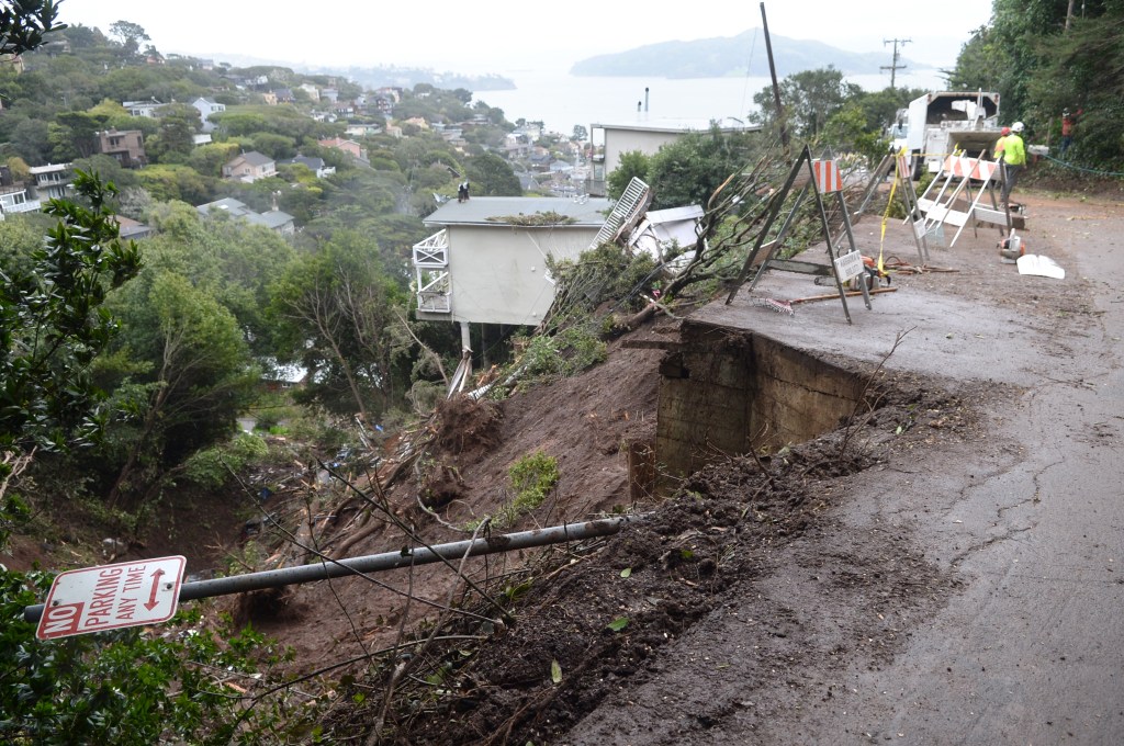
Nearly seven years after a Valentine’s Day 2019 storm wrought havoc in Sausalito, geologists have nearly finished mapping slopes and structures on the city’s 3,397 parcels.
The research, presented at the City Council meeting on Dec. 16, recommends a monitoring system for city-owned roads, buildings, storm drains, retaining walls and other infrastructure that could be vulnerable to landslides. It also lays the foundation for Sausalito to adopt a hillside zoning ordinance next year.
“All of us on the dais would like to see us take all of these actions,” said Vice Mayor Melissa Blaustein.
The 2019 storm caused flooding, power outages, road closures and a pre-dawn mudslide that pushed a duplex off its foundation and down the hillside, where it broke up and destroyed another house in its path. Rescuers pulled a woman from the debris.
“The landslide was just around the corner from where I live,” Sandra Bushmaker, a former council member and mayor, said at the meeting. “I was actually awakened by the landslide itself. There was a lot of air compression and noise that particular morning.”
The disaster led the council to convene a committee to study the city’s vulnerability to landslides and recommend preventative steps.
Bushmaker, who served on the committee, praised the ongoing effort.
“The mapping is really a critical and important element along with the hillside ordinance,” she said.
Before the mudslide, the city’s geologic maps were decades old, when the city was less built out.
“The Geologic Hazard Mapping Study updated the City’s regional geology and slope stability mapping, which was more than 40 years old and utilized topographic data from the 1920s,” a staff report said.
The updated maps indicate that 20% of the city’s parcels are on relatively flat land, with slopes of less than 10%.
The rest are on much steeper hillsides. Nearly 2,000 parcels, or 58% of the city, have slopes of 25 degrees or more. More than 900 parcels, or 27% of the city, have slopes greater than 40 degrees.
“I want to make sure I’m reading a portion of your report correctly,” said Mayor Steven Woodside, who was on the 2019 committee. “You say that approximately 80% of the parcels in Sausalito are susceptible or highly susceptible to landslides.”
City consultant Mike Jewett of Miller Pacific Engineering Group said that was correct, but needed context. That’s because the mapping technology, which includes satellite imagery, assesses the city’s topography one square meter at a time.
“The program is combining that soil property with slope and making that calculation,” he said. “It’s picking up the low retaining walls. It’s picking up rooflines from buildings. It may be picking up trees.”
“This whole study revolves around landslides and the notion of hills sliding down,” Jewett said. “On the other hand, in the interest of public safety, things like sea walls falling over … presents sort of a similar hazard.”
Jewett said his firm would soon complete its mapping and inventory of city infrastructure. City public works officials and planners could then decide what information to exclude as they look to drafting a hillside ordinance.
In five other Marin municipalities, three factors — parcel slope, zone geology and proposed structure — tend to be the thresholds in hillside ordinances that require additional study and possibly engineering before issuing permits, a staff report said.
Corte Madera, Fairfax, Larkspur, Novato and San Rafael all have hillside ordinances. Depending on the project and footprint, parcels with slopes as low as 10 degrees can trigger additional scrutiny.
In Sausalito, approximately 2,740 of the 3,397 parcels are steeper.