
Northern California will see a break in the wet weather on Tuesday, but a powerful storm will send several rounds of potentially damaging winds, heavy rain and heavy snow to the region Tuesday night through Thursday. This comes after some places in the Foothills and Sierra measured 6 to 11 inches of rain since Saturday. The KCRA 3 weather team is issuing Alert Days for Wednesday and Thursday, which are issued to indicate conditions that could prove risky to public safety.Friday is expected to be an Impact Day. Showers and mountain snow will likely cause travel delays, but winds will be calmer.Gov. Gavin Newsom said on Sunday night that emergency response teams and equipment are being deployed to nine counties to protect from flooding and severe weather. KCRA 3 reached out to the governor’s office to find out which counties this applies to. The governor’s office responded, saying that El Dorado, Orange, Lake, Marin, Mendocino, Colusa, Glenn, Plumas and Nevada counties will be receiving the extra equipment and personnel. The first round of high winds and heavy rain will move across the region between 10 pm Tuesday and 4 am Wednesday. Gusts of 40 to 60 mph could cause tree damage in the Valley and Foothills. Scattered power outages are also possible going into Christmas Eve Day. A High Wind Watch was issued by the National Weather Service for the Coastal Hills, Valley and Foothills. It will be in effect from 7 pm Tuesday through 4 am Wednesday.Brief bursts of heavy rain will come with the winds overnight. Most of the daylight hours Wednesday will be calmer with scattered showers in the Valley and steadier rain in the Foothills. Another round of high winds and heavy rain is expected Wednesday night into Thursday morning. The Sacramento Valley could see an additional 1 to 2 inches of rain by Friday. As each band of rain moves east into the Sierra, precipitation will turn into heavy snow. Wednesday’s snow level will be around 6500′. This is low enough for accumulation at the Tahoe area summits. Long delays and chain controls are possible Wednesday.The snow level will drop to 4500′ on Thursday and then 4000′ on Friday. Check the latest chain control information from Caltrans here.In total, the Tahoe area summits could measure several feet of snow by Friday evening. Drivers should avoid traveling in the mountains Wednesday through Friday if possible. Leer en españolShare your weather photos and videos with us at kcra.com/uploadWatch our latest nowcast here REAL-TIME TRAFFIC MAPClick here to see our interactive traffic map.TRACK INTERACTIVE, DOPPLER RADARClick here to see our interactive radar.DOWNLOAD OUR APP FOR THE LATESTHere is where you can download our app.Follow our KCRA weather team on social mediaMeteorologist Tamara Berg on Facebook and X.Meteorologist Dirk Verdoorn on FacebookMeteorologist Heather Waldman on Facebook and X.Meteorologist Kelly Curran on X.Meteorologist Ophelia Young on Facebook and X.Watch our forecasts on TV or onlineHere’s where to find our latest video forecast. You can also watch a livestream of our latest newscast here. The banner on our website turns red when we’re live.We’re also streaming on the Very Local app for Roku, Apple TV or Amazon Fire TV.
Northern California will see a break in the wet weather on Tuesday, but a powerful storm will send several rounds of potentially damaging winds, heavy rain and heavy snow to the region Tuesday night through Thursday.
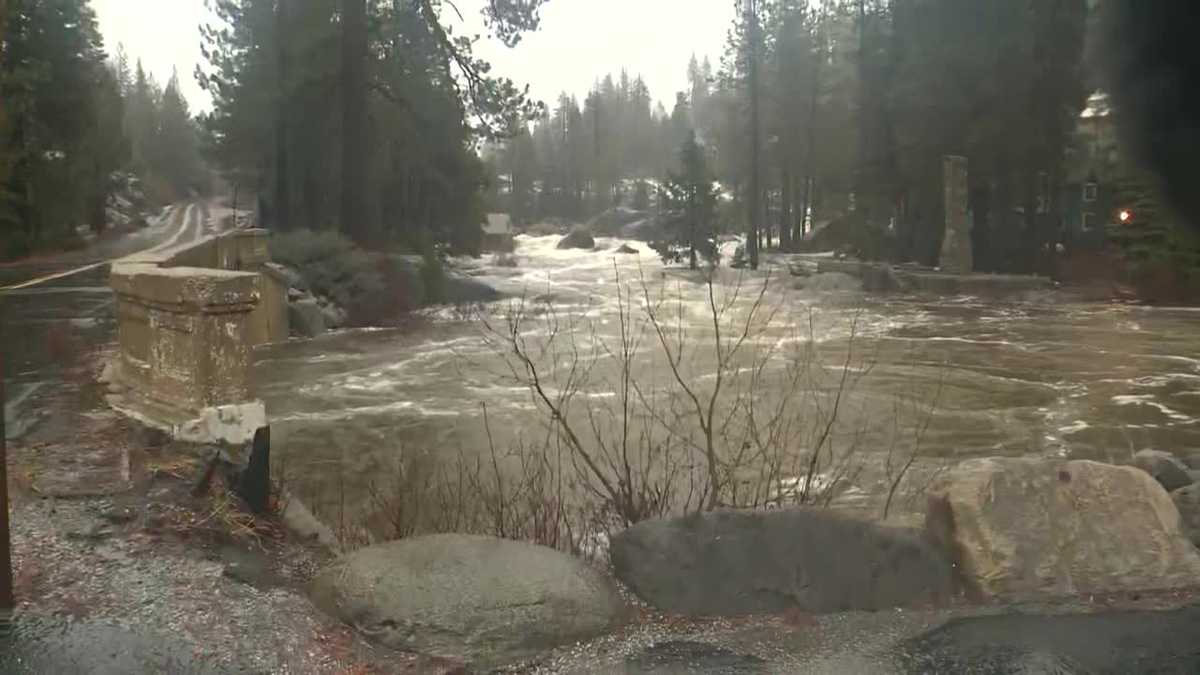
This comes after some places in the Foothills and Sierra measured 6 to 11 inches of rain since Saturday.
The KCRA 3 weather team is issuing Alert Days for Wednesday and Thursday, which are issued to indicate conditions that could prove risky to public safety.

Hearst Owned
Wednesday and Thursday are KCRA 3 weather Alert Days. High winds, heavy rain and heavy snow will significantly impact plans for Christmas Eve and Christmas Day.
Friday is expected to be an Impact Day. Showers and mountain snow will likely cause travel delays, but winds will be calmer.
Gov. Gavin Newsom said on Sunday night that emergency response teams and equipment are being deployed to nine counties to protect from flooding and severe weather. KCRA 3 reached out to the governor’s office to find out which counties this applies to. The governor’s office responded, saying that El Dorado, Orange, Lake, Marin, Mendocino, Colusa, Glenn, Plumas and Nevada counties will be receiving the extra equipment and personnel.
The first round of high winds and heavy rain will move across the region between 10 pm Tuesday and 4 am Wednesday. Gusts of 40 to 60 mph could cause tree damage in the Valley and Foothills. Scattered power outages are also possible going into Christmas Eve Day.
A High Wind Watch was issued by the National Weather Service for the Coastal Hills, Valley and Foothills. It will be in effect from 7 pm Tuesday through 4 am Wednesday.

Hearst Owned
A High Wind Watch will be in effect starting at 7 pm Tuesday.
Brief bursts of heavy rain will come with the winds overnight. Most of the daylight hours Wednesday will be calmer with scattered showers in the Valley and steadier rain in the Foothills.
Another round of high winds and heavy rain is expected Wednesday night into Thursday morning. The Sacramento Valley could see an additional 1 to 2 inches of rain by Friday.
As each band of rain moves east into the Sierra, precipitation will turn into heavy snow. Wednesday’s snow level will be around 6500′. This is low enough for accumulation at the Tahoe area summits. Long delays and chain controls are possible Wednesday.
The snow level will drop to 4500′ on Thursday and then 4000′ on Friday.
In total, the Tahoe area summits could measure several feet of snow by Friday evening. Drivers should avoid traveling in the mountains Wednesday through Friday if possible.

Hearst Owned
Sierra snow will be measured in feet later this week.
REAL-TIME TRAFFIC MAP
Click here to see our interactive traffic map.
TRACK INTERACTIVE, DOPPLER RADAR
Click here to see our interactive radar.
DOWNLOAD OUR APP FOR THE LATEST
Here is where you can download our app.
Follow our KCRA weather team on social media
Meteorologist Tamara Berg on Facebook and X.Meteorologist Dirk Verdoorn on FacebookMeteorologist Heather Waldman on Facebook and X.Meteorologist Kelly Curran on X.Meteorologist Ophelia Young on Facebook and X.
Watch our forecasts on TV or online
Here’s where to find our latest video forecast. You can also watch a livestream of our latest newscast here. The banner on our website turns red when we’re live.
We’re also streaming on the Very Local app for Roku, Apple TV or Amazon Fire TV.