
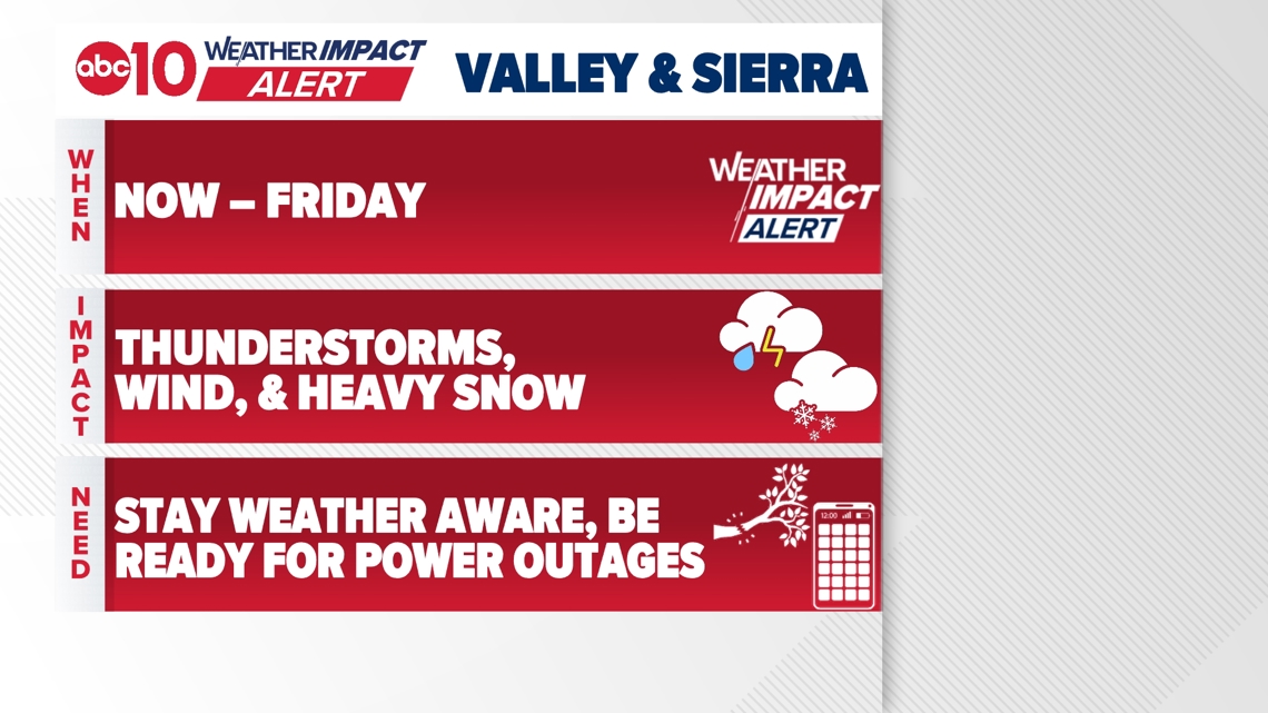
A lot of weather will be impacting Northern California through the holiday, with valley winds and thunderstorms, and heavy Sierra snow.
SACRAMENTO, Calif. — Weather conditions forecast for the Sacramento region include heavy rain, thunderstorms, and very strong winds through Christmas Day!
The main event of this long-duration atmospheric river event is about to come into play. The only thing not in the forecast through Christmas for Northern California is a hurricane! Literally!
Rain and wind pick up overnight Tuesday into Wednesday. Charge phones and devices to be ready for possible power outages.
Christmas Eve and Christmas Day will have multiple weather hazards from thunderstorms, high winds, and heavy rain in the valley. Heavy snow in the high country with possible blizzard conditions.
When
Christmas Eve and Christmas Day – Wednesday and Thursday – are the days with the most weather hazards. A strong atmospheric river returns to Northern California for the holiday bringing a multitude of weather issues.
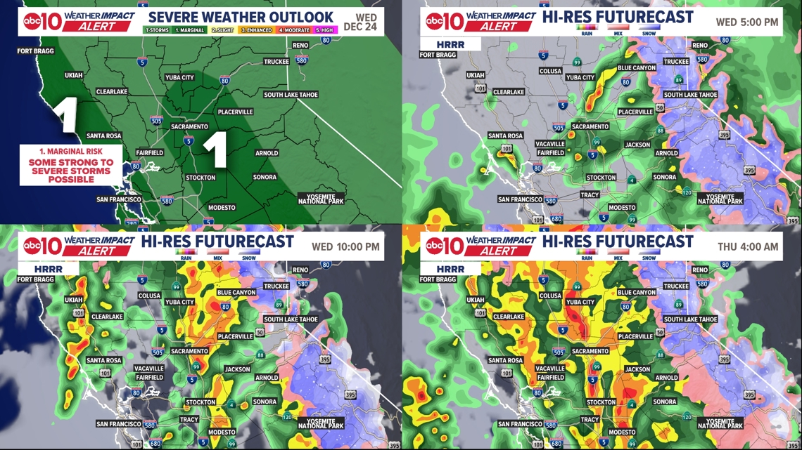
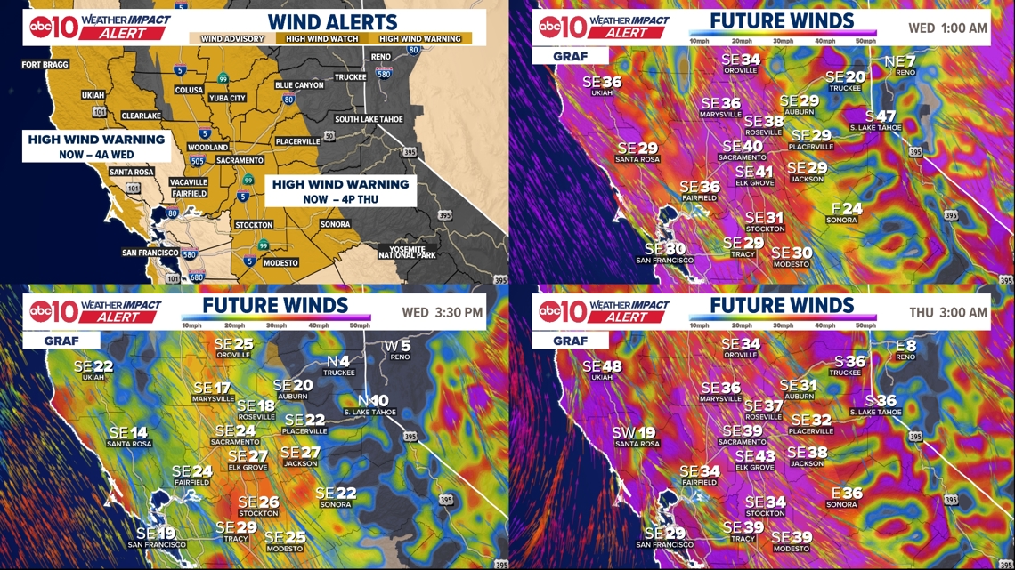
The strongest wind gusts will be overnight Tuesday/Wednesday, then again Wednesday evening through Thursday at lunchtime.Heavy valley rain overnight Tuesday/Wednesday, then a break through the early afternoon on Wednesday. Thunderstorms are possible in the valley for Wednesday afternoon and evening, then again before sunrise on Thursday. Scattered thunderstorm chances remain all day Thursday.Snow starts to fall overnight Tuesday/Wednesday and will continue through Thursday.
► Stay up to date with the forecast and weather impact team with the ABC10+ streaming app. Here’s how to download it for free.
Impact
RAIN & THUNDERSTORMS
The prolonged period of rain will bring the risk of flooding to the Sacramento Valley, northern San Joaquin Valley, northern Sierra Nevada and adjacent foothills, as well as the Coastal Range. A Flood Watch is in effect through Friday, December 26.
Mudslides and rockslides are possible along with rises on rivers. Most of the big concerns are on the north end of the Sacramento river with some monitoring stations passively flowing to nearby floodplains. This helps to ease concerns of downstream flooding in the Capital region. Rounds of heavy rain from Tuesday night through Christmas Day. 2-3″ of valley rain still to come.
Thunderstorm risk goes up Tuesday evening and Wednesday morning with a Level 1 “Marginal” risk for the valley. And thunderstorms that form could produce gusty thunderstorm winds, small hail, and even a brief tornado as there will be a lot of instability and inherent rotation in these discreet thunderstorms.

SNOW
WINTER STORM WARNING from 10p Tuesday to 10p Friday. Snow moves back in overnight Tuesday/Wednesday, and snow levels will be at and below the passes to about 6500 ft. Rounds of heavy snow Christmas Eve with chain controls in effect. Lowering snow levels to 5000 ft on Christmas Day. Heavy snow continues. Gusts over 60mph. Whiteout or even blizzard conditions are possible. 3-6 ft of snow still to come at the passes.
WIND
A HIGH WIND WARNING is in effect across the valley until Thursday afternoon. Overnight wind gusts of to 35-45 mph Tuesday/Wednesday. Winds die down a bit Wednesday during lunchtime before picking up again Wednesday evening. Peak wind gusts from Wednesday evening through Thursday at lunchtime. Widespread 40-50 mph wind gusts, with the strongest gusts approaching 60 mph. Power outages are possible due to the winds.

Weather Impact Resources
► FORECAST DETAILS | Check out our hourly forecast and radar pages
► GET WEATHER ALERTS TO YOUR PHONE | Download the free ABC10 mobile app ► GO DEEPER | Stream in-depth weather forecasts and investigative reports with the free ABC10+ streaming app
► WEATHER IN YOUR EMAIL | Sign up for our daily newsletter
► MEET THE WEATHER IMPACT TEAM | Chief Meteorologist Monica Woods, Brenden Mincheff, Rob Carlmark
Need
The window for travel without weather concerns is now over. Be aware that driving anywhere over the next 48 hours will involve battling some combination of wind, rain, and snow.
Strong wind gusts will pose a threat for power outages. Make sure to charge your devices. Plug in portable chargers if you have them. With wet ground, trees and power poles can topple easier in the high winds.
Don’t tune out! I know it’s the holidays but with the winds and severe weather potential, you’ve gotta stay up to date with what is going on!
ABC10: Watch, Download, Read
For more ABC10 news and weather coverage on your time, stream ABC10+ on your TV for free:
► Roku – click here
► Amazon Fire – click here
► Apple TV – click here
GO DEEPER: The ABC10 Weather Impact Team investigates algae and bacterial threats to some of California’s largest natural lakes.