
Northern California forecast: High Wind Warning in effect through Thursday afternoon
Two rounds of potentially damaging wind gusts will move through the Valley and Foothills along with bursts of heavy rain and Sierra snow.
BUT THE WET WEATHER IS RETURNING. METEOROLOGIST HEATHER WALDMAN IS TRACKING IT FOR US. YEAH, TODAY WAS AN OKAY DAY TO BE OUTSIDE FOR THE VALLEY AND FOOTHILLS. THE WINDS ARE LIGHT. WE’VE GOT THE CLOUDS. IT LOOKS LIKE IT COULD RAIN, BUT IT’S GOING TO STAY DRY THROUGH THE LATE EVENING HOURS. LIVECOPTER3 IS DOING THE HONORS FOR US THIS AFTERNOON. THEY’RE UP OVER THE VALLEY WHERE YOU CAN SEE THE LAYERS TO THE CLOUDS, BUT ALSO A LITTLE BIT OF BRIGHTNESS TRYING TO SHINE IN BETWEEN. IT’S RELATIVELY MILD. TEMPERATURES ARE BACK IN THE LOW 60S, AS EXPECTED. WE’RE IN THE 50S IN THE FOOTHILLS AND WE’RE CLOSE TO 50 DEGREES IN SOUTH LAKE TAHOE. SO AS PRECIPITATION BEGINS LATER TONIGHT, AT LEAST INITIALLY, IT’S GOING TO BE TOO WARM TO SEE ANY SNOW AT LAKE LEVEL. BUT THAT CHANGES AS WE GO THROUGH WEDNESDAY, THURSDAY, AND FRIDAY. HERE’S A LOOK AT THE SUSTAINED WINDS OVER 20MPH IN TRUCKEE AND SOUTH LAKE. IT’S BEEN THAT WAY ALL DAY, BUT THE FOCUS FOR THE WINDS, THE CONCERNING DAMAGING WINDS, IS GOING TO BE IN THE VALLEY AND FOOTHILLS OVERNIGHT TONIGHT AND INTO TOMORROW MORNING, AND THEN A SECOND ROUND COMING TOMORROW EVENING AND LASTING THROUGH THE FIRST HALF OF THE DAY ON CHRISTMAS. SO A HIGH WIND WARNING NOW IN EFFECT, IT WILL STAY IN EFFECT UNTIL 4 P.M. ON THURSDAY. BUT OUR FOCUS IS REALLY THOSE TWO WINDOWS OF HIGH WINDS OVERNIGHT TONIGHT AND THEN OVERNIGHT TOMORROW AND INTO CHRISTMAS MORNING. BUT ALL THE WHILE WE’RE GOING TO BE WATCHING RAIN AND SNOW COMING THROUGH. SO I WANT TO TAKE YOU THROUGH THE TIMING OF THAT. IT’S GOING TO TAKE A COUPLE OF MINUTES. SO HANG TIGHT. THIS IS OVERNIGHT TONIGHT. RAIN FILLING IN ESPECIALLY FOR THE EAST SIDE OF THE VALLEY. WE WILL LIKELY HAVE CHAIN CONTROLS OVER THE SIERRA SUMMITS WHEN THE SUN COMES UP TOMORROW MORNING. THERE’S GOING TO BE A LOT OF DRY TIME TOMORROW FOR THE VALLEY. IF WE GET SOME CLEARING, THERE COULD ACTUALLY BE A COUPLE OF THUNDERSTORMS THAT WE HAVE TO KEEP A CLOSE EYE ON. THE FOOTHILLS WILL BE A LITTLE BIT SOGGIER, BUT I DON’T WANT YOU TO GET THE IDEA THAT TOMORROW IS GOING TO BE A WASHOUT. TOMORROW IS GOING TO BE BREEZY, BUT THE HIGHEST WINDS WILL BE BEFORE 6:00 TOMORROW MORNING, AND THEN THEY’LL START UP AGAIN AROUND 8 OR 9:00 TOMORROW EVENING. SO THIS IS 10 P.M. WEDNESDAY. THIS LINE OF RAIN WILL HAVE HIGH WINDS AHEAD OF IT. SO AS THAT RAIN COMES THROUGH, HEAVY DOWNPOURS, MAYBE EVEN SOME THUNDER AND LIGHTNING, THAT TRANSLATES TO MORE HEAVY SNOW IN THE SIERRA EARLY CHRISTMAS MORNING. I KNOW SOME OF YOU HAVE KIDS THAT ARE GOING TO BE GETTING UP BRIGHT AND EARLY. THIS WHICH WILL BE WAKING UP TO THE WINDS, ARE GOING TO BE HOWLING FOR THE VALLEY AND FOR THE FOOTHILLS. THIS IS GOING TO BE THE STRONGEST POINT OF WINDS THAT I THINK WE SEE OVER THE NEXT FEW DAYS. AND WE’LL HAVE THESE LINES OF VERY HEAVY RAIN COMING THROUGH AS WE GET TO MIDDAY ON THURSDAY. LIKELY STILL WINDY, BUT THE WINDS EASING A LITTLE BIT. SNOW GOING IN THE SIERRA AND WE’LL HAVE THESE HIT AND MISS DOWNPOURS THAT COME THROUGH ALL THE WAY THROUGH THE EVENING. LOOK AT THURSDAY EVENING. THAT’S WHEN THE SNOW LEVEL DROPS DOWN TO 4000FT. SO WHEN THE SIERRA KIND OF PULSES OF SOME OF THE HEAVIER SNOW, BUT ALL DAY THURSDAY AND ALL DAY FRIDAY, I’D AVOID TRAVELING IN THE MOUNTAINS IF YOU CAN. 830 FRIDAY MORNING HIT AND MISS SHOWERS, WINDS. NOT AS MUCH OF AN ISSUE, BUT IT WILL STILL BE BREEZY. WE’RE NOT EXPECTING DAMAGING WINDS AS WE GO THROUGH FRIDAY. THAT’S A LOT TO DIGEST. WE’VE GOT THE DETAILS FOR ALL THE FORECAST. POST FREE NOW@KCRA.COM. HERE’S HOW MUCH ADDITIONAL RAIN WE’RE EXPECTING THROUGH FRIDAY. THIS IS NOT ENOUGH TO CAUSE FLOODING IN THE VALLEY IN THE FOOTHILLS. SO SOME GOOD NEWS THERE. UP TO AN INCH AND A HALF TOTAL FOR SACRAMENTO. UP TO AN INCH IN THE SAN JOAQUIN VALLEY, A LITTLE BIT LESS SO AS YOU GO DOWN INTO STANISLAUS COUNTY. AS FOR TOMORROW IN THE SIERRA, IT’S A RAIN AND SNOW MIX FOR TRUCKEE AND SOUTH LAKE TAHOE. I WOULD ANTICIPATE SNOW GETTING OVER DONNER SUMMIT, ECHO SUMMIT AND OVER CARSON PASS AS WELL. POLLOCK PINES AND ARNOLD. IT WILL BE BREEZY, BUT THE HIGHER WINDS WILL BE FARTHER DOWN THE HILL. THE FOOTHILLS ARE GOING TO START OFF VERY WINDY TOMORROW MORNING. ONCE WE GET PAST 8 A.M. I THINK THE WINDS ARE NOTICEABLE, BUT THEY’RE LIGHTER AND THEN WE’LL SEE THOSE ROUNDS OF RAIN, MAYBE EVEN A THUNDERSTORM COMING THROUGH THROUGH THE AFTERNOON. HIGH WINDS ARE LIKELY MOST OF THE DAY FOR THE IMMEDIATE COAST. SAN FRANCISCO WET, WINDY WITH A HIGH TEMPERATURE OF 60 DEGREES. AND WE’LL BE WATCHING FOR THOSE WINDS EARLY IN THE MORNING. AND THEN LATER TOMORROW EVENING FOR THE SAN JOAQUIN VALLEY. RAIN SHOWERS ARE KIND OF HIT AND MISS THROUGHOUT THE DAY. YOU’RE GOING TO HAVE DRY TIME TO WORK WITH, BUT REMEMBER, IT’S GOING TO BE BREEZY AS WELL. STRONGEST WINDS WILL BE BEFORE 6 A.M. TOMORROW, AND THEN AFTER 8 P.M. TOMORROW. SO THE DAYLIGHT HOURS RELATIVELY TAME, BUT WATCHING FOR THOSE HIT AND MISS DOWNPOURS FOR THAT SECOND ROUND OF HIGH WINDS COMES IN AS WE GO THROUGH WEDNESDAY NIGHT AND THURSDAY. THERE’S A QUICK LOOK AT THE FOOTHILLS AND THE SIERRA AGAIN, OUR WEATHER ALERT DAYS AS WE GO THROUGH WEDNESDAY AND THURSDAY, AND THE SEVEN DAY FORECAST FOR THE VALLEY IS QUIE
Meteorologist/Climate Reporter
Northern California forecast: High Wind Warning in effect through Thursday afternoon
Two rounds of potentially damaging wind gusts will move through the Valley and Foothills along with bursts of heavy rain and Sierra snow.

Updated: 5:52 PM PST Dec 23, 2025
Meteorologist/Climate Reporter
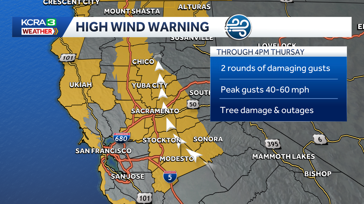
A powerful storm will bring rounds of high winds, heavy rain and heavy Sierra snow to Northern California Tuesday night through Friday.A High Wind Warning is now in effect through 4 p.m. on Thursday for the Valley and lower Foothills.Two rounds of potentially damaging wind gusts are expected during that time. The first will blow through overnight Tuesday into Wednesday morning. Peak gusts of 45 to 55 mph are possible. Leer en español.A second, longer-lasting round of wind will pick up Wednesday evening and last through Thursday morning. This second blast of wind could be stronger than the first, with some areas seeing wind gusts of 60 mph. Either round of high winds could cause tree damage and power outages. Winds will weaken Thursday evening.Bursts of heavy rain and Sierra snow will come with each round of wind. Expect on and off downpours for the Valley and Foothills Wednesday, Thursday and Friday. Rain will not be heavy or persistent enough for flooding issues.For those with travel plans in the Sierra, expect chain controls and some delays on Wednesday as the snow level drops to 6,500 feet. This is low enough for significant accumulations over Donner and Echo Summit as well as Carson Pass. Travel will become much more difficult Thursday and Friday as the snow level drops below 5,000 feet. By Friday evening, Donner Summit could see 4 to 6 feet of heavy snow. Locations at 6,000 feet could see up to 2 feet of snow. Up to a foot of wet snow is possible down to 5,000 feet. The weekend will be much quieter with a couple stray showers Saturday morning, then dry weather with light winds into the start of next week.REAL-TIME TRAFFIC MAPClick here to see our interactive traffic map.TRACK INTERACTIVE, DOPPLER RADARClick here to see our interactive radar.DOWNLOAD OUR APP FOR THE LATESTHere is where you can download our app.Follow our KCRA weather team on social mediaMeteorologist Tamara Berg on Facebook and X.Meteorologist Dirk Verdoorn on FacebookMeteorologist Heather Waldman on Facebook and X.Meteorologist Kelly Curran on X.Meteorologist Ophelia Young on Facebook and X.Watch our forecasts on TV or onlineHere’s where to find our latest video forecast. You can also watch a livestream of our latest newscast here. The banner on our website turns red when we’re live.We’re also streaming on the Very Local app for Roku, Apple TV or Amazon Fire TV.
A powerful storm will bring rounds of high winds, heavy rain and heavy Sierra snow to Northern California Tuesday night through Friday.
A High Wind Warning is now in effect through 4 p.m. on Thursday for the Valley and lower Foothills.
Two rounds of potentially damaging wind gusts are expected during that time. The first will blow through overnight Tuesday into Wednesday morning. Peak gusts of 45 to 55 mph are possible.
A second, longer-lasting round of wind will pick up Wednesday evening and last through Thursday morning. This second blast of wind could be stronger than the first, with some areas seeing wind gusts of 60 mph.
Either round of high winds could cause tree damage and power outages. Winds will weaken Thursday evening.
Bursts of heavy rain and Sierra snow will come with each round of wind. Expect on and off downpours for the Valley and Foothills Wednesday, Thursday and Friday. Rain will not be heavy or persistent enough for flooding issues.
For those with travel plans in the Sierra, expect chain controls and some delays on Wednesday as the snow level drops to 6,500 feet. This is low enough for significant accumulations over Donner and Echo Summit as well as Carson Pass.
Travel will become much more difficult Thursday and Friday as the snow level drops below 5,000 feet. By Friday evening, Donner Summit could see 4 to 6 feet of heavy snow. Locations at 6,000 feet could see up to 2 feet of snow. Up to a foot of wet snow is possible down to 5,000 feet.
The weekend will be much quieter with a couple stray showers Saturday morning, then dry weather with light winds into the start of next week.
REAL-TIME TRAFFIC MAP
Click here to see our interactive traffic map.
TRACK INTERACTIVE, DOPPLER RADAR
Click here to see our interactive radar.
DOWNLOAD OUR APP FOR THE LATEST
Here is where you can download our app.
Follow our KCRA weather team on social media
Meteorologist Tamara Berg on Facebook and X.Meteorologist Dirk Verdoorn on FacebookMeteorologist Heather Waldman on Facebook and X.Meteorologist Kelly Curran on X.Meteorologist Ophelia Young on Facebook and X.
Watch our forecasts on TV or online
Here’s where to find our latest video forecast. You can also watch a livestream of our latest newscast here. The banner on our website turns red when we’re live.
We’re also streaming on the Very Local app for Roku, Apple TV or Amazon Fire TV.