
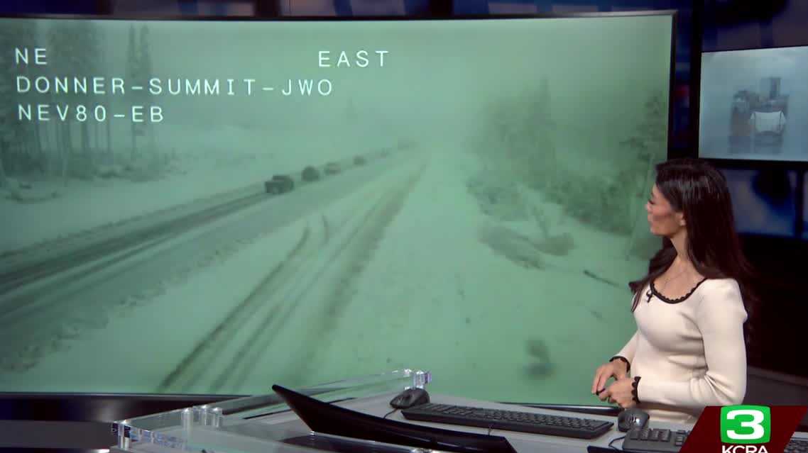
WE’LL SEND IT ON OVER TO OPHELIA YOUNG. YEAH. THANKS, LIANE. WE’RE LOOKING OUT AT ALL OF OUR CAMERAS. WE STILL HAVE THE CLOUD COVER BEHIND THE RAIN, BUT NOW WE’RE SEEING A LITTLE SUN PEEK THROUGH THOSE CLOUDS. AND THAT IS AN INDICATOR THAT THUNDERSTORMS ARE POSSIBLE LATER ON TODAY AS THAT SUN COMES OUT TO WARM UP THE GROUND, MORE MOISTURE WILL MOVE IN LATER THIS EVENING, AND WE COULD GET SOME THUNDER AND LIGHTNING, SO WATCH OUT FOR THAT IF YOU HAVE PLANS THIS EVENING. RIGHT NOW, TEMPERATURES IN THE MID 50S IN THE VALLEY. WE HAVE 52 IN THE FOOTHILLS IN THE SIERRA. IT’S COMING DOWN PRETTY GOOD. TEMPERATURES AROUND 36 DEGREES. AND IT LOOKS LIKE THIS ALONG I-80 NEAR DONNER SUMMIT. BLANKET OF SNOW. I SAW ON THE WEBSITE THAT THEY ARE SCREENING FOR CHAINS IN SOME SPOTS. SO IF YOU’RE GOING TO BE DRIVING IN THE MOUNTAINS TODAY, YOU’LL DEFINITELY WANT TO CHECK INTO THE WEBSITE AND MAKE SURE THAT YOU ARE AWARE OF ROAD CONDITIONS. BUT THIS IS GREAT NEWS FOR THE MOUNTAINS BECAUSE SNOW HAS BEEN HARD TO COME BY SINCE THE STORM ARRIVED LAST WEEK IN EBBETTS PASS IN SPOTS IN HIGHER ELEVATIONS LIKE PALISADES TAHOE, THEY HAVE GOTTEN MORE THAN A FOOT OF SNOW. MOUNT ROSE MORE THAN TWO FEET OF SNOW, BUT IN AREAS AT LAKE LEVEL TRUCKEE FEW SNOWFLAKES. NOTHING IMPRESSIVE, BUT WE ARE SEEING ON THE SATELLITE RADAR RIGHT NOW THAT THAT SNOW IS BEGINNING TO DROP IN LEVELS. AND THAT DOES MEAN MORE AND MORE SNOW FOR THE MOUNTAINS OVER THE NEXT COUPLE OF DAYS. HOW MUCH ARE THEY EXPECTING? 2 TO 4FT IN ECHO SUMMIT, 1 TO 2FT IN SOUTH LAKE TAHOE, IN CARSON’S PASS, UP TO SEVEN FEET OF SNOW IS POSSIBLE, A LITTLE BIT LOWER IN ELEVATION. BLUE CANYON A HALF FOOT TO A FOOT POSSIBLE THESE NEXT FEW DAYS. SO IN THE SIERRA TODAY, EXPECT SNOW. TEMPERATURES ARE GOING TO TOP OUT ONLY IN THE LOW 40S IN THE FOOTHILLS. RAINY CONDITIONS ALL THROUGH THE AFTERNOON AND TEMPERATURES WILL TOP OUT IN THE MID 50S. AND HERE IN THE VALLEY IT WILL BE DRIER, BREEZY, BUT THE WIND AND THE SNOW DOE
Northern California forecast: Preparing for more winds, rain Wednesday evening

Updated: 11:21 AM PST Dec 24, 2025
Wednesday morning’s winds are easing in the Valley, but stronger winds will arrive overnight into Christmas morning.Meanwhile, winds are increasing in the Sierra for a windy day as the storm shifts east out of the Valley.In the Valley, expect a partly cloudy day with highs in the upper 50s. Rain will continue in the foothills, with temperatures warming into the mid-50s. Highs in the Sierra will be in the low 40s as snow levels continue to drop. Rain will transition to snow, which will continue through the day and night.Another cold front approaches this evening, and winds will pick up again. As the front draws in more moisture, thunderstorms are possible in the Valley this evening.Wednesday is likely to see another windy night with periods of moderate to heavy rain. The cold front passes Christmas morning, but breezes will linger as additional energy follows the front, along with a few lingering showers.REAL-TIME TRAFFIC MAPClick here to see our interactive traffic map.TRACK INTERACTIVE, DOPPLER RADARClick here to see our interactive radar.DOWNLOAD OUR APP FOR THE LATESTHere is where you can download our app.Follow our KCRA weather team on social mediaMeteorologist Tamara Berg on Facebook and X.Meteorologist Dirk Verdoorn on FacebookMeteorologist/Climate Reporter Heather Waldman on Facebook and X.Meteorologist Kelly Curran on X.Meteorologist Ophelia Young on Facebook and X.Watch our forecasts on TV or onlineHere’s where to find our latest video forecast. You can also watch a livestream of our latest newscast here. The banner on our website turns red when we’re live.We’re also streaming on the Very Local app for Roku, Apple TV or Amazon Fire TV.See more coverage of top California stories here | Download our app | Subscribe to our morning newsletter | Find us on YouTube here and subscribe to our channel
SACRAMENTO, Calif. —
Wednesday morning’s winds are easing in the Valley, but stronger winds will arrive overnight into Christmas morning.
Meanwhile, winds are increasing in the Sierra for a windy day as the storm shifts east out of the Valley.
In the Valley, expect a partly cloudy day with highs in the upper 50s. Rain will continue in the foothills, with temperatures warming into the mid-50s. Highs in the Sierra will be in the low 40s as snow levels continue to drop. Rain will transition to snow, which will continue through the day and night.
Another cold front approaches this evening, and winds will pick up again. As the front draws in more moisture, thunderstorms are possible in the Valley this evening.
Wednesday is likely to see another windy night with periods of moderate to heavy rain. The cold front passes Christmas morning, but breezes will linger as additional energy follows the front, along with a few lingering showers.
REAL-TIME TRAFFIC MAP
Click here to see our interactive traffic map.
TRACK INTERACTIVE, DOPPLER RADAR
Click here to see our interactive radar.
DOWNLOAD OUR APP FOR THE LATEST
Here is where you can download our app.
Follow our KCRA weather team on social media
Meteorologist Tamara Berg on Facebook and X.Meteorologist Dirk Verdoorn on FacebookMeteorologist/Climate Reporter Heather Waldman on Facebook and X.Meteorologist Kelly Curran on X.Meteorologist Ophelia Young on Facebook and X.
Watch our forecasts on TV or online
Here’s where to find our latest video forecast. You can also watch a livestream of our latest newscast here. The banner on our website turns red when we’re live.
We’re also streaming on the Very Local app for Roku, Apple TV or Amazon Fire TV.
See more coverage of top California stories here | Download our app | Subscribe to our morning newsletter | Find us on YouTube here and subscribe to our channel