
What to KnowA rainy December delivers one more storm that will bring rain into New Year’s Day for the Rose Parade in Pasadena. Peak rainfall arrives early Thursday morning with more scattered showers for the remainder of New Year’s Day. Evacuation warnings go into effect through Thursday night for Los Angeles County wildfire burn zones. Flash flood watches also will be in effect through Thursday night for widespread parts of Southern California. Some mountain roads are closed due to damage from last week’s storm and in anticipation of possible rockslides from the upcoming rain.
Evacuation warnings and flash flood watches will be in effect Thursday as Southern California begins 2026 and closes out a wet December that had one more storm in store.
The most significant rainfall from the storm that arrived on New Year’s Eve is expected early Thursday. The system isn’t expected to be as powerful as last week’s storm, which brought several days of rain and led to flooding, but it will add more rain to already saturated hillsides in wildfire burn zones and dampen streets and freeways.
Expect light to moderate rainfall with the possibility of thunderstorms.
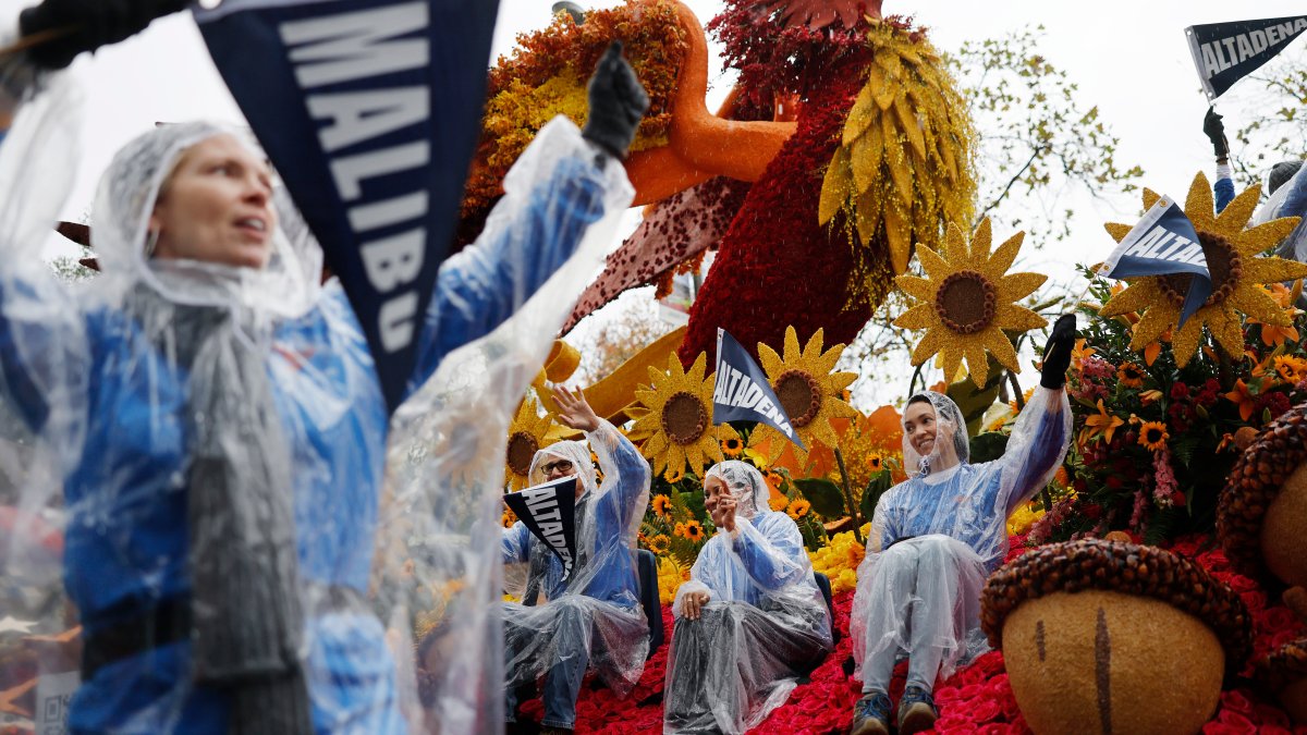
The timing of the storm means wet weather for overnight campers lining the route for the New Year’s Day Rose Parade. Thursday’s rain will be the first in 20 years during the Rose Parade. City officials said it has rained 10 times during the parade in the event’s history.
Evacuation warnings, meaning residents should be prepared for evacuation orders, go into effect Wednesday through most of Thursday for Los Angeles County burn scars, including the Eaton Fire in Altadena and the Palisades Fire. Most go into effect at 11 a.m. Wednesday.
Click here to send us your weather photos
The California Governor’s Office of Emergency Services was positioning fire and rescue personnel and resources in areas most at risk for flooding and damaging debris flows.
Some mountain roads are closed due to damage from last week’s storm and in anticipation of possible rockslides from the upcoming rain.
Rain is expected for tomorrow’s Rose Parade in Pasadena. Michelle Valles reports for the NBC4 News at 6 a.m. on Dec. 31, 2025.
Here’s the timeline for the holiday storm. This information will be updated when the timing changes.
Wednesday: Light showers that gradually made their way into Southern California became more widespread as the day progressed, marking a soggy start to 2026. Flash flood watches will be in effect for widespread parts of Southern California until 10 p.m. Thursday.
“Some of these pockets of heavy rainfall, those start to come on Thursday,” said NBC4 meteorologist Kelley Moody.
Thursday: The heaviest rain arrives early Thursday morning, but continues through about 8 a.m. — just as the Rose Parade gets underway on Colorado Boulevard in Pasadena. Camping along the parade route began at midday Wednesday.
Note: Umbrellas are not permitted at the parade, so ponchos and rain jackets are heavily advised.
“It’s not like what we had here last week when we had a stream of moisture hovering the area that didn’t move a whole lot,” NBC4 meteorologist Stephanie Olmo said. “This is going to be moving pretty quickly as we continue into the morning.”
“By the time the Rose Parade ends, you might get a little bit of a break, but we’re still expecting to see some spotty showers out there as we head into the early afternoon hours,” Moody said.
And, that likely means damp conditions for the Rose Bowl game at 1 p.m. between No. 1 Indiana and No. 9 Alabama.
Scattered showers continue Thursday evening with showers lingering in some areas Friday. Another round of rain is possible Saturday into Sunday with more rain in next week’s forecast.
Estimated rainfall amounts range from 1 to 3 inches for most areas with 2 to 5 inches in the mountains.
The next storm expected in SoCal is causing concern for residents in burn scar areas. Lauren Coronado reports for the NBC4 News at 6 a.m. on Dec. 31, 2025.
Storm evacuation warnings
Evacuation warnings begin at 11 a.m. Wednesday for burn scars, including the Palisades, Eaton, Agua Dulce, Franklin, Bridge, Kenneth and Canyon fires, due to the possibility of mud or debris flows. The city of Los Angeles also issued an evacuation warning for the Sunset Fire area in the Hollywood Hills.
Southern California hillsides, already saturated from a Christmas-week storm that soaked the region for several days, will likely receive several more inches of rain from this week’s storm.
Recently burned hillsides are particularly vulnerable to mudslides and debris flows because flames stripped vegetation that helped hold soil in place. High rainfall rates can trigger water runoff that can pick up loose soil, rocks and debris.
Mountain road closures
All lanes of State Route 2 are closed near Cedar Springs, 3.3 miles east of Newcomb’s Ranch, to State Route 138 in San Bernardino County. It was not immediately clear when the scenic route will reopen with another wet weather system expected this week.
The closure is one of several in the Southern California mountains ahead of more rain. Along the 5 Freeway north of Los Angeles, both Tejon Pass rest areas are closed near Gorman. In Ventura County, State Route 33 is closed between Fairview Road and Lockwood Valley Road in Los Padres National Forest.
Topanga Canyon Boulevard remains closed between Grandview Drive and Pacific Coast Highway in western Los Angeles County.