
MAPS: Track Doppler radar and traffic for California rain and snow
Follow the storms with interactive radar and see the latest traffic conditions.
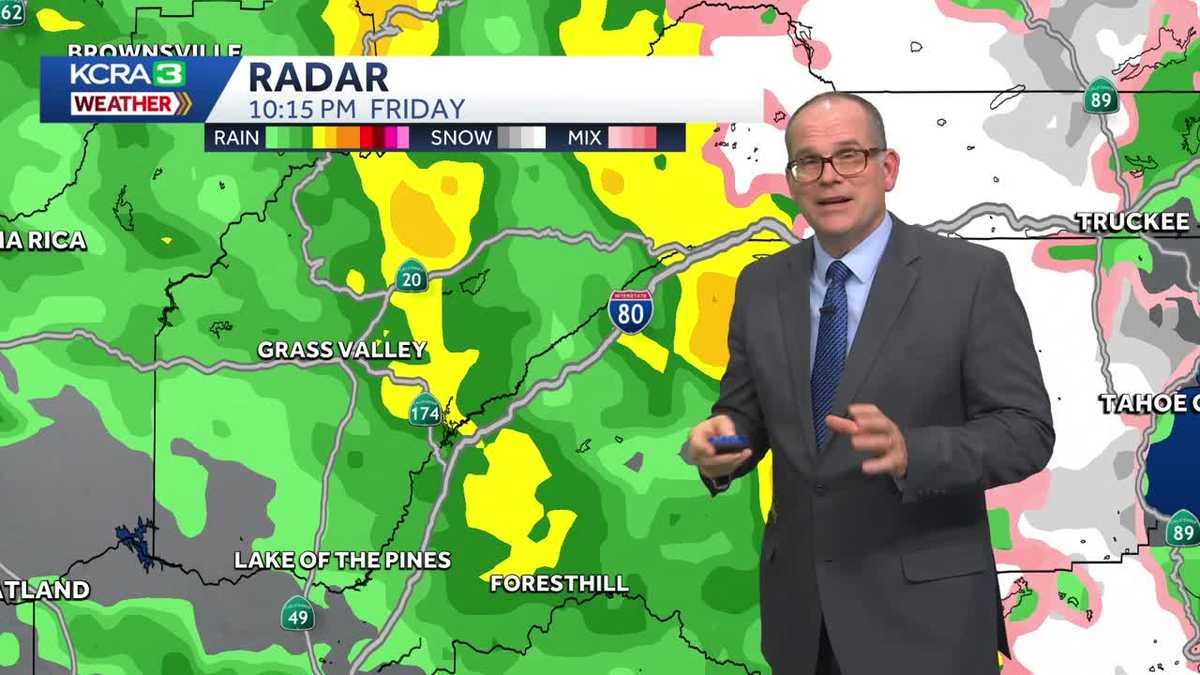
IS IN THE FORECAST. LET’S CHECK IN WITH DIRK. WE CAN GO AHEAD AND TAKE A LOOK AT WHERE WE HAVE SOME RAIN CURRENTLY, AND WE ARE SEEING, AT LEAST IN THE MARIN AREA, A LITTLE BIT OF A BREAK, BUT THERE’S MORE RAIN THAT’S DEVELOPING OFF THE COAST OF CALIFORNIA. AND BEYOND THAT YOU CAN SEE THERE’S SOME LIGHTNING STRIKES. SO WE HAVE SOME INSTABILITY. AND THAT’S GOING TO BE THE STORY AS WE HEAD INTO SATURDAY. BUT TONIGHT IT’S JUST THE RAIN. WE’RE SEEING MOSTLY LIGHT TO MODERATE RAIN, BUT SOME POCKETS OF HEAVIER RAIN ARE HERE OR THERE. AND YOU CAN SEE MODESTO CURRENTLY GETTING SOME RAIN. AND THEN TO THE NORTH, STRETCHING ALL THE WAY UP TO LONDON AND THEN INTO WALLACE AND LAKE COMANCHE AREA. WE’RE SEEING SOME OF THAT MORE MODERATE RAINFALL. WE’RE SEEING SOME POCKETS ALSO IN BETWEEN SONORA AND COPPEROPOLIS. IT LOOKS LIKE NEAR COLUMBIA. YOU’RE GOING TO BE SEEING THAT AS WELL AS ANGELS CAMP, FOREST MEADOWS, ARNOLD MURPHYS ALSO GETTING SOME OF THAT RAIN. HEAVIER RAIN NEAR ESPARTO. WE’RE SEEING THAT NORTH OF KNIGHTS LANDING. AND AGAIN, THESE SHOWERS ALL WORKING THEIR WAY OFF TO THE NORTH AND TO THE EAST AS THEY CUT ACROSS THE VALLEY AND HEAD INTO THE SIERRA, WHERE WE HAVE AGAIN, SOME AREAS OF HEAVY RAIN. IT LOOKS LIKE JUST NORTH OF NEVADA CITY. AND THEN WORKING YOUR WAY UP OVER BLUE CANYON, YOU CAN SEE THAT RAIN REALLY PICKS UP. AND THEN AS YOU GET CLOSER, OF COURSE, TO THE SUMMIT, WE HAVE THAT TRANSITION GOING TO GET UP ABOVE 6500FT. YOU SEE THAT TRANSITION FROM RAIN TO SNOW. AND IT’S A FAIRLY WET SNOW. AND AS SOON AS IT HITS THE ROAD SO FAR IT’S BEEN MELTING. AND THAT SHOULD BE THE CASE THROUGH THE NIGHT. TONIGHT, WITH SNOW LEVELS THAT WILL BE FLUCTUATING BETWEEN 6500 TO 7000FT. SO HOW MUCH RAIN HAVE WE HAD SO FAR? WELL, THIS IS THE LATEST ROUND THAT WE’VE HAD AND IT’S BEEN INTERESTING TO SEE. SO THE BAY AREA SAN FRANCISCO LOOK AT THAT. 4/10 OF AN INCH CLOSE TO A QUARTER OF AN INCH IN VACAVILLE. BUT ALL THOSE HEAVIER SHOWERS THEN MOVED NORTH. SO MARYSVILLE GOT 14 HUNDREDTHS OF AN INCH, QUARTER OF AN INCH IN OROVILLE. AND THEN THEY KIND OF TAPERED OFF. OTHER THAN THAT, WE’VE ONLY HAD FOUR HUNDREDTHS IN SACRAMENTO. NOT EVEN MEASURABLE YET. IN STOCKTON, WE’LL BE SEEING SOME MEASURABLE RAIN I’M SURE SOON IN MODESTO. AND AMOUNTS HAVE BEEN FAIRLY LIMITED SO FAR. BUT AGAIN, RIGHT NOW WE’RE SEEING SOME OF THAT HEAVIER RAIN JUST WORKING ITS WAY UP THE WEST SLOPE OF THE SIERRA INTO THE SOUTHERN PORTION OF OUR FORECAST AREA. SO FROM BASICALLY CALAVERAS COUNTY SOUTH, THESE ARE THE RAIN AMOUNTS THAT WE’RE EXPECTING SATURDAY, TOMORROW, ANYWHERE FROM HALF AN INCH TO AN INCH. AND THAT’S UP AND DOWN THE VALLEY A LITTLE BIT LESS TO THE SOUTH, A LITTLE BIT MORE TO THE NORTH. COME SUNDAY. KIND OF SIMILAR SITUATION AGAIN, A LITTLE BIT LESS TO THE SOUTH, A LITTLE BIT MORE TO THE NORTH. BUT WE COULD SEE A HALF AN INCH TO AN INCH IN THE VALLEY. AND THEN MONDAY IT TAPERS OFF. WE’RE STILL GOING TO GET RAIN, BUT IT’S ONLY GOING TO BE BETWEEN ABOUT A 10TH OF AN INCH TO A THIRD OF AN INCH IS WHAT WE’RE GOING TO BE SEEING NOW. AS FAR AS THE SNOW IN THE SIERRA, SNOW LEVELS, WE’RE GOING TO BE GOING FROM 7000FT, DROPPING DOWN TO 6000FT THROUGH SATURDAY. SO WE GET INTO SATURDAY NIGHT, IT’S GOING TO BE CLOSE TO 6000FT. THEN SUNDAY WE’RE LOOKING AT GOING FROM 6000FT DOWN TO 5000FT SUNDAY NIGHT AND INTO MONDAY. AND THEN MONDAY IT LOOKS LIKE IT’S GOING TO BE ABOUT 4500FT. SO WE’LL EVENTUALLY SEE THOSE SNOW LEVELS DROPPING AND WE’LL SEE THOSE ACCUMULATIONS REALLY PICKING UP. I THINK ON SUNDAY AND MONDAY RIGHT NOW, TEMPERATURES, IT’S STILL PRETTY WARM 57 DEGREES IN SACRAMENTO, 60 IN STOCKTON, AS WELL AS MODESTO LAKE TAHOE CURRENTLY 41 DEGREES. WE HAD A DAYTIME HIGH TODAY IN SACRAMENTO, 61 DEGREES. IT’S BEEN A WARM START TO OUR JANUARY HERE IN 2026. NORMALLY WE’RE AT 55 DEGREES IN A RECORD TEMPERATURE. FOR THIS DATE 67 DEGREES. BACK IN 2014. WINDS. WE’RE SEEING SOME OF THE STRONGER WINDS RIGHT NOW. WE HAVE WIND SPEEDS ANYWHERE FROM EIGHT MILES PER HOUR UP TO 22MPH. IN THE VALLEY. WE HAVE 23 MILE AN HOUR SOUTHERLY WINDS IN PLACERVILLE, 18 IN TRUCKEE, AS WELL AS LAKE TAHOE. SO THERE’S THE WIND, SUSTAINED WINDS OF 24 CURRENTLY IN SAN FRANCISCO, WITH WIND GUSTS CLOSE TO 40MPH. IN SAN FRANCISCO, WIND GUSTS OF BETWEEN 20 TO 30 TO 32MPH CURRENTLY IN STOCKTON. SO WE HAVE THESE WINDS AND THEY’RE JUST GOING TO BE WITH US OVER THE NEXT COUPLE OF HOURS. YOU CAN SEE THE WINDS AND THE GUSTS WILL BE BETWEEN 30 TO 40MPH. SUSTAINED WINDS BETWEEN 15 TO 20. AND THEN THE WINDS TAPER OFF INTO TOMORROW. IT’LL STILL BE A LITTLE BREEZY, BUT IT’S NOT GOING TO BE TOO BAD. THIS WEATHER SYSTEM IS GOING TO MOVE THROUGH. WE’RE LOOKING AT VALLEY CONDITIONS THAT WILL BE WET, PERIODS OF RAIN, AND THEN WE HAVE THE CHANCE FOR SOME THUNDERSTORMS IN THE AFTERNOON. SO WE’LL BE SEEING THAT AS WE GET PAST NOON AND THROUGH ABOUT 6:00 THROUGH THE FOOTHILLS. SIMILAR SITUATION, A LITTLE BREEZY, BUT THE CHANCE FOR THUNDERSTORMS. THAT’S WHAT WE’RE WATCHING INTO THE FOOTHILLS BY TOMORROW AFTERNOON AS WELL. AND IN THE SIERRA IT’S GOING TO BE THE SNOW PICKING UP AS WE GET INTO THE AFTERNOON. SO EXPECT TO HAVE CONDITIONS THAT ARE GOING TO BE VERY WINTRY
MAPS: Track Doppler radar and traffic for California rain and snow
Follow the storms with interactive radar and see the latest traffic conditions.

Updated: 6:21 PM PST Jan 2, 2026
Saturday is expected to bring the potential of severe weather in Northern California, along with heavy rain and wind. Snow is also expected to impact travel in the Sierra on Sunday. Here is where to find live, interactive radar and traffic maps on KCRA.com to help keep you prepared during weather events in California. Track the latest forecast here. Download our app for the latest breaking news and severe weather alertsHere is where you can download our app for the latest weather alerts.Track real-time traffic updates in Northern California here(App users, click here to see our interactive traffic map.)Track California Doppler radar here(App users, click here to see our interactive radar map.)Track California highway road conditions hereHere is where you can search Caltrans road conditions by highway and see if chain controls are in effect. Here are key websites to prepare for and track California power outages.Preparing for power outages: Ready.gov explains how to prepare for a power outage and what to do when returning from one here.Keeping informed when you’ve lost power and cellphone service: How to find a National Weather Service radio station near you.Here is how to sign up for CalAlerts emergency alert notifications for any county in California.Track PG&E power outages here. Track SMUD outages here. Track power outages across all California counties. Follow our KCRA weather team on social mediaMeteorologist Tamara Berg on Facebook and XMeteorologist Dirk Verdoorn on FacebookMeteorologist Heather Waldman on Facebook and XMeteorologist Kelly Curran on Facebook and X.Meteorologist Ophelia Young on Facebook and X. Watch our forecasts on TV or onlineHere’s where to find our latest video forecast. You can also watch a livestream of our latest newscast here. The banner on our website turns red when we’re live.We’re also streaming on the Very Local app for Roku, Apple TV or Amazon Fire TV.Send us your photos and videosShare your weather photos and videos at kcra.com/upload.
Saturday is expected to bring the potential of severe weather in Northern California, along with heavy rain and wind.
Snow is also expected to impact travel in the Sierra on Sunday.
Here is where to find live, interactive radar and traffic maps on KCRA.com to help keep you prepared during weather events in California.
Track the latest forecast here.
Download our app for the latest breaking news and severe weather alerts
Here is where you can download our app for the latest weather alerts.
Track real-time traffic updates in Northern California here
(App users, click here to see our interactive traffic map.)
Track California Doppler radar here
(App users, click here to see our interactive radar map.)
Track California highway road conditions here
Here is where you can search Caltrans road conditions by highway and see if chain controls are in effect.
Here are key websites to prepare for and track California power outages.Follow our KCRA weather team on social mediaMeteorologist Tamara Berg on Facebook and XMeteorologist Dirk Verdoorn on FacebookMeteorologist Heather Waldman on Facebook and XMeteorologist Kelly Curran on Facebook and X.Meteorologist Ophelia Young on Facebook and X. Watch our forecasts on TV or online
Here’s where to find our latest video forecast. You can also watch a livestream of our latest newscast here. The banner on our website turns red when we’re live.
We’re also streaming on the Very Local app for Roku, Apple TV or Amazon Fire TV.
Send us your photos and videos
Share your weather photos and videos at kcra.com/upload.