
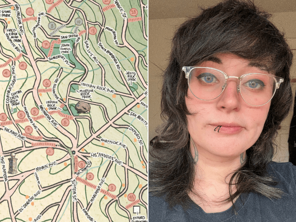
Since moving to Berkeley a few years ago from San Jose, Danielle Hopkins has fallen for what she calls a “diverse, hodgepodge little city,” and she is especially smitten with the architecture, nature and people of the Berkeley Hills.
 Danielle Hopkins. Courtesy: Hopkins
“It ended up being the love of my life — I never want to leave,” said Hopkins, a tattoo artist and illustrator who works in Modern Electric Studio in South Berkeley. “The Berkeley Hills are magical. This is almost like its own little village; the neighborhood here is absolutely so pleasant.”
Her fondness for the Berkeley Hills inspired her to create a tattoo flash sheet, a collection of illustrations that clients can pick from, inspired by its nature and landmarks. Then, in mid-October 2024, Hopkins had the idea to hand draw a pictorial map of the hills — the paths, stairways, rock parks and winding streets all meticulously detailed with muted colors in what she calls a “vintage cartography style.”
The map, which she said serves as her personal “love letter to Berkeley,” is a bit more fanciful and freewheeling than the popular map of the hills sold by the Berkeley Path Wanderers Association (BPWA), though both tread similar territory.
 Hopkins’ hand-drawn map of the Berkeley Hills took her dozens of hours over around 7 months. Click to enlarge. Courtesy: Hopkins
Using a combination of Google Maps, Apple Maps, AllTrails and the BPWA map as guides, Hopkins drew her map freehand using the Procreate app on an iPad.
Later, she refined her work using the grid-drawing method, tracing over her source image box by box to break it down and get the proportions correct. She also updated the color scheme, created a border and added numerous small images like a manzanita tree, a deer, and a bicycle — things that she’s seen in the hills that contribute to its character.
In making the map, she got lots of helpful suggestions from her partner, Marcus MacDonald, who works in the cartography team at the autonomous taxi company Zoox.
“He himself was trying to make a map of the hills extending to Tilden park and beyond,” she said. “His knowledge is more GIS-based [but] he taught me so many things.”
After uploading an initial version of the map to Nextdoor on March 20, her post got over 6,000 views in 24 hours and she was flooded with responses, with many asking how they could get a printed version.
The day after posting to Nextdoor, 10 to 15 people came to her house to buy a copy of the map, Hopkins said. Hopkins has now sold about 30 maps.
“It was just wonderful because I get to meet my neighbors and hear their stories,” she said. “It was an old couple that came over, and somebody with their dog, somebody with their baby. It was a really wholesome experience for me.”
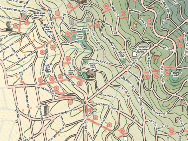 A close-up view of the map. Courtesy: Hopkins
Among her fans is Colleen Neff, former president of the BPWA. Neff doesn’t see Hopkins’ map as competition; the BPWA map, developed over 20 years, includes not only public stairways and paths, but also highlights bicycle boulevards and lanes, wheelchair-accessible paths and public restrooms, and it remains the definitive map of the Berkeley Hills.
Hopkins’ map, Neff said, is “so beautiful that I assume it was made as a poster for framing or mounting on a wall. The small illustrations like the rose by the Rose Garden, the waterfall up on Shasta Road, etc. are very charming, as is all the hand-drawn text. I also love the deepening of the green areas as the terrain becomes steeper in the hills.”
Hopkins has given away about 15 of her maps for free, including one to an older neighbor with whom she said she became “best of friends” through the exchange.
The feeling of community is what she finds most endearing about Berkeley.
“I never felt like I really belonged in San Jose, and here I feel more accepted by everyone,” she said.
Hopkins’ favorite part of the Berkeley Hills is the Tamalpais Path, which she said is a “grueling and awful” hike up concrete stairs, but one that rewards you with a view of the Bay Area from over the redwoods.
To buy a physical copy of Hopkins’ completed map ($40), you can fill out her preorder form. She also has a Linktree that redirects to her graphic novel for sale, her portfolio website, and an Etsy page selling sticker sheets of various Bay Area cities.
Related stories
Remembering Steve Glaeser, who did the heavy lifting to make paths in the Berkeley Hills
February 6, 2024Feb. 6, 2024, 8:39 a.m.
She’s written over 60 poems on a fence in the Berkeley Hills
October 13, 2023Oct. 13, 2023, 10:38 a.m.
‘Berkeley Walks’ guidebook, made for those who love to wander, gets first update since 2018
July 6, 2023July 6, 2023, 4:29 p.m.
“*” indicates required fields