
For the first time in 25 years, the US Drought Monitor shows that no area of California is experiencing unusually dry or drought conditions. The Drought Monitor tracks and reports on the development or recovery of short and long-term drought patterns across the U.S. (Video Above: Series of holiday storms gave NorCal’s water supply a big boost)Experts analyze recent rainfall, snowpack, streamflow, soil moisture and climatology to assess the severity of drought conditions, ranking them on a scale ranging from “abnormally dry” to “extreme drought.”Updates to the drought monitor are released once a week, and Thursday was the first time that no areas in California were highlighted in any of the five drought categories.It is important to recognize that drought is tricky to define, especially for California’s climate, which is defined by long periods of dry weather. The U.S. Drought Monitor is an imperfect tool for capturing the many nuances of the state’s water cycle, but there’s no question that the current water year is off to a wet start.National Weather Service data shows that many Valley cities have seen above-average rainfall since the water year began on Oct. 1. Sacramento and Redding are both at 140% of normal rainfall. Bakersfield, San Diego and Los Angeles have more than doubled their average rain over the past couple of months. The mountains have been wet, too. One metric for tracking moisture in the Sierra is called the 8-Station Index. This tool averages rain and snowfall for eight locations in the north and central Sierra. As of Thursday, Jan. 8, precipitation for those 8 locations is at 32.8 inches. That is 160% of normal and the second wettest on record for this point in the season. The 8-Station Index is computed using both rain and snow. This year has featured several warm, wet storms with little to no snowfall. Storms over the holidays were much better snow producers, but more snow is needed in the months ahead to shore up the spring snowpack and resulting water supply for the lower elevations in the summer. As of Thursday, California’s statewide snowpack numbers are at 91% of average for the date, but just 38% of the average peak.A dry pattern is setting back up for much of the West this week. Long-range forecast data suggests that this stretch could last at least a couple of weeks. REAL-TIME TRAFFIC MAPClick here to see our interactive traffic map.TRACK INTERACTIVE, DOPPLER RADARClick here to see our interactive radar.DOWNLOAD OUR APP FOR THE LATESTHere is where you can download our app.Follow our KCRA weather team on social mediaMeteorologist Tamara Berg on Facebook and X.Meteorologist Dirk Verdoorn on FacebookMeteorologist/Climate Reporter Heather Waldman on Facebook and X.Meteorologist Kelly Curran on X.Meteorologist Ophelia Young on Facebook and X.Watch our forecasts on TV or onlineHere’s where to find our latest video forecast. You can also watch a livestream of our latest newscast here. The banner on our website turns red when we’re live.We’re also streaming on the Very Local app for Roku, Apple TV or Amazon Fire TV.
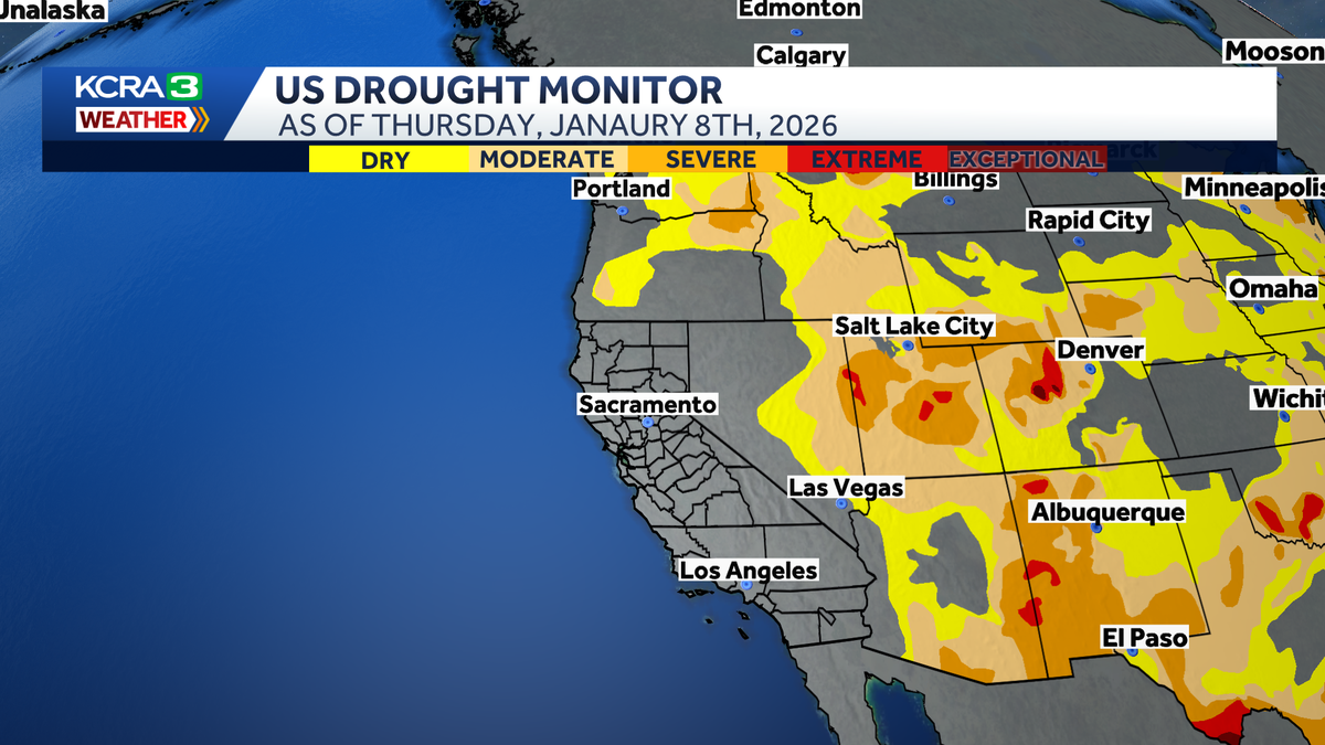
For the first time in 25 years, the US Drought Monitor shows that no area of California is experiencing unusually dry or drought conditions.
The Drought Monitor tracks and reports on the development or recovery of short and long-term drought patterns across the U.S.
(Video Above: Series of holiday storms gave NorCal’s water supply a big boost)
Experts analyze recent rainfall, snowpack, streamflow, soil moisture and climatology to assess the severity of drought conditions, ranking them on a scale ranging from “abnormally dry” to “extreme drought.”

Hearst Owned
Thursday’s update to the US Drought Monitor does not have any part of California highlighted in a drought category.
Updates to the drought monitor are released once a week, and Thursday was the first time that no areas in California were highlighted in any of the five drought categories.
It is important to recognize that drought is tricky to define, especially for California’s climate, which is defined by long periods of dry weather. The U.S. Drought Monitor is an imperfect tool for capturing the many nuances of the state’s water cycle, but there’s no question that the current water year is off to a wet start.

Hearst Owned
Many cities in the Valley have been much wetter than normal the past couple of months.
National Weather Service data shows that many Valley cities have seen above-average rainfall since the water year began on Oct. 1. Sacramento and Redding are both at 140% of normal rainfall. Bakersfield, San Diego and Los Angeles have more than doubled their average rain over the past couple of months.
The mountains have been wet, too. One metric for tracking moisture in the Sierra is called the 8-Station Index. This tool averages rain and snowfall for eight locations in the north and central Sierra. As of Thursday, Jan. 8, precipitation for those 8 locations is at 32.8 inches. That is 160% of normal and the second wettest on record for this point in the season.

Hearst Owned
The 8 station index shows much wetter than normal conditions in the north and central Sierra.
The 8-Station Index is computed using both rain and snow. This year has featured several warm, wet storms with little to no snowfall. Storms over the holidays were much better snow producers, but more snow is needed in the months ahead to shore up the spring snowpack and resulting water supply for the lower elevations in the summer.
As of Thursday, California’s statewide snowpack numbers are at 91% of average for the date, but just 38% of the average peak.
A dry pattern is setting back up for much of the West this week. Long-range forecast data suggests that this stretch could last at least a couple of weeks.

Hearst Owned
Long range forecast data indicates that a dry pattern could last for a couple of weeks.
REAL-TIME TRAFFIC MAP
Click here to see our interactive traffic map.
TRACK INTERACTIVE, DOPPLER RADAR
Click here to see our interactive radar.
DOWNLOAD OUR APP FOR THE LATEST
Here is where you can download our app.
Follow our KCRA weather team on social media
Meteorologist Tamara Berg on Facebook and X.Meteorologist Dirk Verdoorn on FacebookMeteorologist/Climate Reporter Heather Waldman on Facebook and X.Meteorologist Kelly Curran on X.Meteorologist Ophelia Young on Facebook and X.
Watch our forecasts on TV or online
Here’s where to find our latest video forecast. You can also watch a livestream of our latest newscast here. The banner on our website turns red when we’re live.
We’re also streaming on the Very Local app for Roku, Apple TV or Amazon Fire TV.