
Northern California forecast: Patchy fog in the Valley, sunshine for the Foothills
Areas of dense fog are present in the Valley this morning and may be slow to dissipate while the Foothills and Sierra experience more sunshine and mild temperatures.
THE WATER TANK. IT IS NOW 447 AS WE TAKE A LIVE LOOK HERE. RANCHO CORDOVA SKY CAMERA. IT’S NOT FOG, IS IT, KELLY? I MEAN, IS IT JUST KIND OF. ATMOSPHERE? I GUESS WE’RE STARTING TO SEE FOG DEVELOPING IN SOME LOCATIONS, SO THIS MAY JUST BE THE BEGINNING OF THAT. NOW, AS WE TAKE THIS LOOK OUTSIDE. THIS IS FROM SUTTER HEALTH BALLPARK. THINGS STILL LOOKING CLEAR. GOT A GOOD VIEW OF THE TOWER BRIDGE AND THE BUILDINGS HERE IN DOWNTOWN. TEMPERATURES ARE COLD. IT IS 37 DEGREES. THE WINDS ARE CALM AS WE HEAD LATER INTO THE DAY. WE DO EXPECT TO SEE THOSE TEMPERATURES CLIMBING INTO THE MID AND UPPER 40S BY NOON, BUT NOTICE STILL SOME LINGERING CLOUDS AROUND IN THE VALLEY. ESPECIALLY WHERE WE SEE THAT FOG DEVELOP, WHICH WE’LL SEE MORE OF AS WE GET CLOSER TO SUNRISE, WHICH IS A LITTLE AFTER SEVEN. NOW WE’RE WE’RE SEEING FOG. CURRENTLY THAT’S AROUND TRUCKEE, WHERE VISIBILITY IS ALREADY REDUCED DOWN TO ABOUT A QUARTER OF A MILE. SACRAMENTO EXECUTIVE AIRPORT NOW REPORTING VISIBILITY AT A MILE AND A HALF. WE’RE ALSO SEEING A LITTLE BIT OF FOG NEAR FAIRFIELD AND SOME PRETTY DENSE FOG NEAR SANTA ROSA, MODESTO IT’S FOGGY A MILE AND A HALF VISIBILITY THERE. SO THAT HAS GONE DOWN JUST IN THE LAST 30 MINUTES OR SO. AND WE DO EXPECT TO SEE MORE FOG DEVELOPING THROUGHOUT THE MORNING. SATELLITE IMAGERY NOT REALLY SHOWING MUCH OTHER THAN THE FOG. SKIES ARE GENERALLY CLEAR. SO FOR THE FOOTHILLS AND FOR THE SIERRA, THAT MEANS A REALLY SUNNY DAY. HIGH PRESSURE IS IN CONTROL. THAT’S GOING TO BE THE CASE THROUGHOUT THE WEEK THIS WEEK. SO WE’RE TALKING LIGHT WINDS, WARMER TEMPERATURES, AT LEAST FOR THE FOOTHILLS IN THE SIERRA. BUT FOR THE VALLEY, THAT MEANS WE WILL LIKELY SEE SOME FOG. NOW TODAY IT LOOKS LIKE IT MIGHT BE PRETTY PATCHY, BUT LATER IN THE WEEK WE DO EXPECT TO SEE THAT MORE WIDESPREAD FOG THAT WILL LINGER LATER AND LATER EACH DAY. SO YEAH, REMEMBER WHEN WE BACK TOWARD THANKSGIVING? WE WERE DEALING WITH THAT ALL DAY KIND OF FOG. THAT IS A POSSIBILITY AGAIN THIS WEEK. NOW HIGH PRESSURE STARTS TO WEAKEN AS WE HEAD TOWARD THE WEEKEND. AND THEN A LOW PRESSURE SYSTEM MOVES IN AS WE HEAD TOWARD THE MIDDLE OF NEXT WEEK. THAT ONE BRINGING THE CHANCE FOR SHOWERS BUT A LITTLE BIT FURTHER TO OUR NORTH. SEVEN DAY FORECAST FOR THE FOOTHILLS. YOU ARE LOOKING OUT. WE’RE TALKING UPPER 50S TO AROUND 60 DEGREES TODAY WITH PLENTY OF SUNSHINE. BUT LOOK AT THAT. BY FRIDAY, SUNNY AND 64, IT LOOKS LIKE YOU’VE GOT A FANTASTIC WEEKEND NEXT WEEKEND FOR THE SIERRA. LOTS OF SUNSHINE HERE AS WELL. NO SNOW IN THE FORECAST. WARMING UP THOUGH MID 50S SO WE MAY SEE SOME OF THAT SNOW MELTING. THEN AS WE TAKE A LOOK AT THE SEVEN DAY FORECAST, A LOT MORE CLOUDS HERE. AND THAT IS LIKELY BECAUSE OF THE FOG. LIKE I SAID WHERE WE SEE THAT FOG DEVELOP, THAT’S WHERE WE’LL SEE THOSE CLOUDS LINGERING LONGER AND LONGER EACH DAY, AND IT KEEPS THE TEMPERATURES DOWN. GOTCHA. ALL RIGHT. THAN
Northern California forecast: Patchy fog in the Valley, sunshine for the Foothills
Areas of dense fog are present in the Valley this morning and may be slow to dissipate while the Foothills and Sierra experience more sunshine and mild temperatures.

Updated: 5:13 AM PST Jan 12, 2026
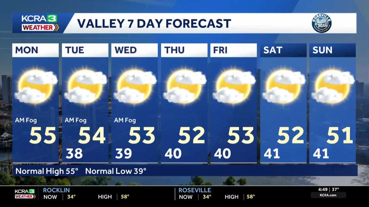
Areas of dense fog are developing in Valley Monday morning and may be slower to dissipate than over the weekend. More fog is expected each morning through at least Wednesday. Lingering fog will keep temperatures cooler in the Valley, especially when compared to the Foothills where abundant sunshine is forecast throughout the week. The same high pressure that is allowing for the development of fog in the Valley, is bringing sunshine and mild temperatures for the higher elevations. In the Foothills, high temperatures will gradually climb this week, reaching the mid 60s by Friday. Snow will be melting in the Sierra as high temperatures reach the mid 50s by the middle of the week. No precipitation, rain or snow, is expected during the 7 day period.
SACRAMENTO, Calif. —
Areas of dense fog are developing in Valley Monday morning and may be slower to dissipate than over the weekend. More fog is expected each morning through at least Wednesday. Lingering fog will keep temperatures cooler in the Valley, especially when compared to the Foothills where abundant sunshine is forecast throughout the week.
The same high pressure that is allowing for the development of fog in the Valley, is bringing sunshine and mild temperatures for the higher elevations. In the Foothills, high temperatures will gradually climb this week, reaching the mid 60s by Friday. Snow will be melting in the Sierra as high temperatures reach the mid 50s by the middle of the week.
No precipitation, rain or snow, is expected during the 7 day period.