
Northern California forecast: Friday fog to hazy sun, conditions stay dry
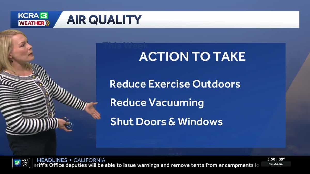
BUT UNFORTUNATELY, IT LOOKS LIKE THE NEXT SEVEN DAYS ANYWAY. WE’RE GOING TO STAY DRY, RIGHT? WE ARE. AND WHERE WE REALLY COULD USE A BIT MORE OF A BOOST IS IN THE SNOWPACK NOW. SNOW. I WAS JUST UP IN IT AND THE QUALITY IS GOOD AND ALL OF THAT, BUT IT’S ALMOST LIKE THE MIDDLE PART OF THE DAY. IT RIDES LIKE A SPRING DAY. YEAH, WE’VE HAD A GOOD COLD OVERNIGHTS, WHICH I GUESS HAS HELD IT UP AND THEY’VE BEEN ABLE TO MAKE A LOT OF SNOW AS WELL. THE RESORTS THAT HAVE THE SNOW MAKING EQUIPMENT FOR SURE IN THE FORECAST. YES, IT IS GOING TO BE DRY IN THE NEXT FEW DAYS. WHAT WE’RE FACING AS YOU HEAD OUT THE DOOR THIS MORNING IS THE FOG. THIS IS ACTUALLY THE STOCKTON AND VENICE HEALTH ARENA SKY CAMERA. YOU REALLY DON’T SEE MUCH OF ANYTHING. TEMPERATURES RIGHT NOW ARE IN THE UPPER 30S TO LOW 40S. SO GRAB THE LAYER AND IF YOU HAVE TO GO OUT IN STOCKTON, ESPECIALLY AROUND DOWNTOWN, YOU’RE GOING INTO THAT. SO MAKE SURE THAT YOU DO HAVE A LITTLE BIT OF EXTRA TIME. GIVE YOURSELF THAT BUFFER OF TIME TO GET TO YOUR LOCATION. WE’RE DOWN TO THE TEENS THIS MORNING AND EVEN INTO CLOSE TO SINGLE DIGITS RIGHT NOW AROUND TRUCKEE, WHERE THERE IS SOME AREAS OF FREEZING FOG, REDUCED VISIBILITY DOWN TO LESS THAN TWO MILES. THERE AT THE TRUCKEE AIRPORT, YOU’RE WAKING UP FOG FREE. AUBURN, PLACERVILLE AND SONORA. BUT IF YOU HAVE PLANS TO DRIVE INTO THE VALLEY FROM THE FOOTHILLS, HERE’S WHAT YOU’RE GOING TO BE FACING. A DROP IN VISIBILITY SACRAMENTO, FAIRFIELD, STOCKTON AND MODESTO. AND AGAIN, THERE WILL BE SOME AREAS WHERE YOU’RE PRETTY MUCH FOG FREE OR THE FOG IS ELEVATED, AND THEN YOU GET INTO SOME OF THOSE HEAVIER BANDS OF FOG. THAT’S PRETTY MUCH HOW THE MORNING IS GOING TO PLAY OUT. OTHER THING WE HAVE TO CONTEND WITH TODAY IS THE AIR QUALITY. WE’RE GOING TO BE IN BETWEEN THE MODERATE TO UNHEALTHY FOR SENSITIVE GROUP CATEGORY. SO IF YOU DO HAVE ANY HEART OR LUNG AILMENTS, DEFINITELY A DAY THAT YOU WANT TO PAY ATTENTION TO. SOME OF THE ACTION YOU CAN TAKE IS TRY TO REDUCE ANY STRENUOUS ACTIVITY OUTDOORS. REDUCE VACUUMING. YOU DON’T WANT TO STIR UP MORE DUST PARTICLES. AND IF YOU CAN, OF COURSE I KNOW IT’S GOING TO BE A BEAUTIFUL DAY. YOU HAVE TO KEEP IN MIND, SHUTTING THE DOORS AND WINDOWS WILL BE GOOD TO KEEP SOME OF THOSE FINER PARTICULATES OUT. BIG AREA OF HIGH PRESSURE STARTS TO MOVE TO THE NORTH AS WE ADVANCE INTO SATURDAY AND SUNDAY. A LITTLE WEAK SYSTEM OFF THE COAST WILL HELP TO BRUSH US WITH SOME CLOUDS AS WE GET INTO SUNDAY. BUT NO RAIN, NO SNOW OUT OF THOSE CLOUDS. AND AS THE AREA OF HIGH PRESSURE BUILDS BACK FOR MONDAY, WE’VE GOT A GREAT FORECAST WITH A TOUCH OF A NORTH BREEZE THAT WILL HELP TO KEEP THINGS POTENTIALLY FOG FREE FOR ANY OF THE OBSERVANCES FOR MLK DAY OUTDOORS. THEN WE GET INTO TUESDAY AND WEDNESDAY. WE’RE STILL LOOKING AT A DRY FORECAST, BUT LOOK AT WEDNESDAY WE’RE GOING TO BE SEEING NOT AS MUCH OF THAT BEAUTIFUL BLUE SKY, BUT MORE CLOUD COVER. ANOTHER SYSTEM IS GOING TO DROP INTO PLACE. WE GET THROUGH THURSDAY. THIS 1ST MAY BE THE GAME CHANGER FOR US, POTENTIALLY BRINGING IN THE POTENTIAL FOR SOME RAIN IN THE FOOTHILLS, MAYBE SOME MOUNTAIN SNOW SHOWERS. EXTENDED FORECAST AGAIN, THAT WOULD BE HAPPENING NOT UNTIL THURSDAY. AND THEN AS YOU LOOK AT THE FORECAST HERE IN THE VALLEY, PRETTY MUCH A RINSE AND REPEAT FORECAST, IF YOU WILL. MORNING AREAS OF FOG, HAZY SUN IN THE AFTERNOONS AND TEMPERATURES THAT ARE GOING TO BE KIND OF LOCKED INTO CRUISE CONTROL, LOW 60S THROUGH THE WEEKEND AND INTO MLK DAY. THOSE MORNINGS QUITE COOL AND POTENTIALLY FOGGY, JUST DEPENDS ON WHERE YOU LIVE. YEAH. ALL RIGHT. THANK YOU TAMARA. APPRECIATE IT. AND AGAIN FOG NOT HELPING OR HURTING. IF YOU’RE WEST OF I-5 BASICAL
Northern California forecast: Friday fog to hazy sun, conditions stay dry

Updated: 6:50 AM PST Jan 16, 2026
The Sacramento Valley will see some dense pockets of fog for the Friday morning commute.Fog will lift around noon, and the sun will be out with widespread areas of haze.Highs are likely to stay above normal, reaching the low to mid-60s. The weekend looks dry. Much of the same pattern lingers: morning fog for the valley and hazy sun for the afternoon. Temperatures could drop slightly into the weekend as a weak system brings some clouds through by Sunday. Expect valley highs into the low 60s. Martin Luther King Jr. Day looks dry for outdoor events. Mostly sunny skies are expected with highs across the region into the 60s. The dry pattern looks to stick around through at least late next week. A weak system may bring some mountain showers back by next Thursday.REAL-TIME TRAFFIC MAPClick here to see our interactive traffic map.TRACK INTERACTIVE, DOPPLER RADARClick here to see our interactive radar.DOWNLOAD OUR APP FOR THE LATESTHere is where you can download our app.Follow our KCRA weather team on social mediaMeteorologist Tamara Berg on Facebook and X.Meteorologist Dirk Verdoorn on FacebookMeteorologist/Climate Reporter Heather Waldman on Facebook and X.Meteorologist Kelly Curran on X.Meteorologist Ophelia Young on Facebook and X.Watch our forecasts on TV or onlineHere’s where to find our latest video forecast. You can also watch a livestream of our latest newscast here. The banner on our website turns red when we’re live.We’re also streaming on the Very Local app for Roku, Apple TV or Amazon Fire TV.See more coverage of top California stories here | Download our app | Subscribe to our morning newsletter | Find us on YouTube here and subscribe to our channel
SACRAMENTO, Calif. —
The Sacramento Valley will see some dense pockets of fog for the Friday morning commute.
Fog will lift around noon, and the sun will be out with widespread areas of haze.
Highs are likely to stay above normal, reaching the low to mid-60s.
The weekend looks dry. Much of the same pattern lingers: morning fog for the valley and hazy sun for the afternoon.
Temperatures could drop slightly into the weekend as a weak system brings some clouds through by Sunday. Expect valley highs into the low 60s.
Martin Luther King Jr. Day looks dry for outdoor events. Mostly sunny skies are expected with highs across the region into the 60s.
The dry pattern looks to stick around through at least late next week. A weak system may bring some mountain showers back by next Thursday.
REAL-TIME TRAFFIC MAP
Click here to see our interactive traffic map.
TRACK INTERACTIVE, DOPPLER RADAR
Click here to see our interactive radar.
DOWNLOAD OUR APP FOR THE LATEST
Here is where you can download our app.
Follow our KCRA weather team on social media
Meteorologist Tamara Berg on Facebook and X.Meteorologist Dirk Verdoorn on FacebookMeteorologist/Climate Reporter Heather Waldman on Facebook and X.Meteorologist Kelly Curran on X.Meteorologist Ophelia Young on Facebook and X.
Watch our forecasts on TV or online
Here’s where to find our latest video forecast. You can also watch a livestream of our latest newscast here. The banner on our website turns red when we’re live.
We’re also streaming on the Very Local app for Roku, Apple TV or Amazon Fire TV.
See more coverage of top California stories here | Download our app | Subscribe to our morning newsletter | Find us on YouTube here and subscribe to our channel