
Morning fog Saturday then gusty winds develop clearing clouds temporarily. Fog returns by Sunday then tracking possible showers next week.
SACRAMENTO, Calif — A chance in the weather pattern coming this weekend, but it still starts with morning fog.
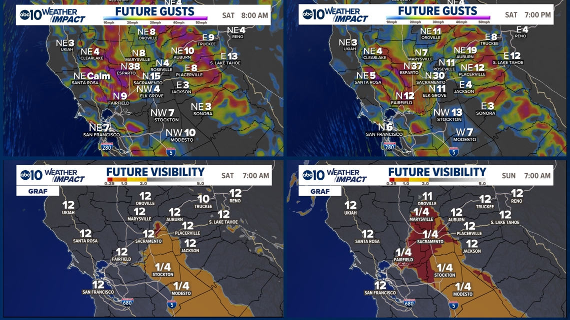
Winds will increase early Saturday morning through the day. This will help erode the valley fog that has plagued much of the work week keeping afternoon highs chilly through much of the week. Some areas struggled to make it out of the 40s on Friday due to the persistent low clouds.
The wind shift will certainly help to minimize the coverage and duration of the fog on Saturday. Areas that are slow to see wind increase, like the Southern Sacramento Valley, Delta and Northern San Joaquin Valley, will still have limited visibility on Saturday morning. Those conditions improve before noon s winds kick up and help dry out skies and reduce low cloudiness.
Mostly sunny skies are expected for much of the afternoon which will help drive up temperatures back to near and even above normal to start the weekend.
This will be a short lived but impactful weather shift giving many valley residents a break from the grey skies. If you are heading to the Sierra prepare for gusty winds on Saturday. This could impact some ski resorts.
Winds start to calm overnight though with the return to patchy low clouds once again to end the weekend plus increasing midday clouds from a system pulling in from the Pacific.

It’s been over 16 days since we’ve seen rain. The average winter dry stretch of at least 15 days lasts for 25 days. The longest such dry stretch since 1990 was Dec 2021-March 2022 and lasted for 75 days!
There’s a slight chance of showers brushing through quickly next Wednesday but the long range outlook is still favoring a likely warmer and drier outlook through the beginning of February. The state is still largely dominated by high pressure although some weak systems will be moving through next week with that chance of showers and occasional clouds.
Follow the weather forecast with the ABC10 Weather Impact Team on ABC10+. Here’s more on how to stream ABC10+ weather forecasts for free wherever you stream on television.
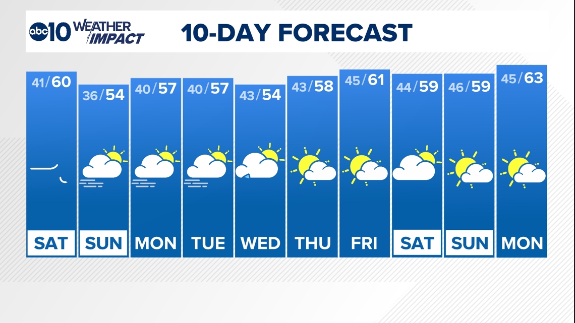
TONIGHT: Fog forming with lows in the 40s. Lake Tahoe lows in the teens.
SATURDAY: Morning fog then breezy north winds with sunny afternoon skies and highs in the upper 50s to near 60°. Lake Tahoe highs in the mid-30s.
SUNDAY: Mostly cloudy with highs in the mid-50s. Lake Tahoe highs in the low 40s.
MONDAY: Morning fog then mostly cloudy with highs in the mid to upper 50s. Lake Tahoe highs in the low 40s.
TUESDAY: Patchy fog then partly cloudy with highs in the mid to upper 50s. Lake Tahoe highs in the mid-40s.
WEDNESDAY: Mostly cloudy with a slight chance of showers. Highs in the low to mid-50s. Lake Tahoe highs in the mid-40s.
THURSDAY: Mostly cloudy with highs in the upper 50s. Lake Tahoe highs in the mid-40s.
FRIDAY: Mostly cloudy with highs near 60°. Lake Tahoe highs in the mid-40s.
SATURDAY, JANUARY 31: Mix of sun and clouds with highs in the upper 50s. Lake Tahoe highs in the mid-40s.
SUNDAY, FEBRUARY 1: Mix of sun and clouds with highs in the upper 50s. Lake Tahoe highs in the mid-40s.
► FORECAST DETAILS | Check out our hourly forecast and radar pages.
► GET WEATHER ALERTS TO YOUR PHONE | Download the ABC10 mobile app
► WEATHER IN YOUR EMAIL | Sign up for the ABC10 Today newsletter
► GO DEEPER | Stream in-depth weather forecasts on ABC10+
► MEET THE WEATHER TEAM | Chief Meteorologist Monica Woods, Brenden Mincheff, Rob Carlmark
ABC10: Watch, Download, Read