
Northern California forecast: Dense, patchy fog ahead of light rain and snow
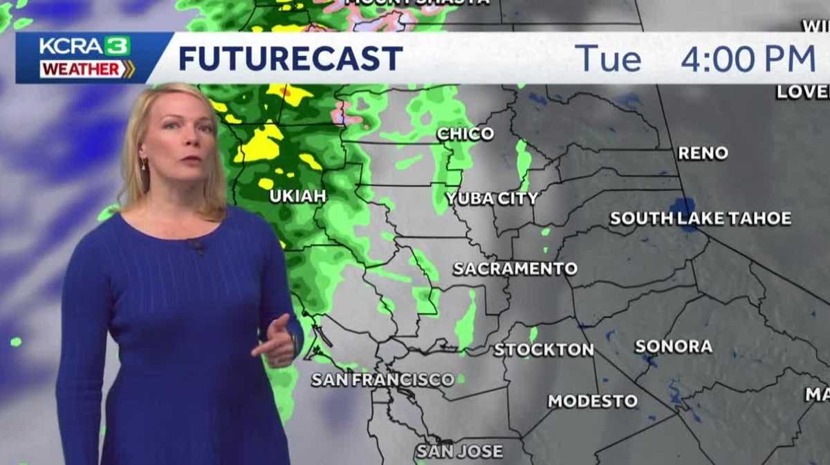
WILL HERYFORD SKYCAM. TEO AND I BOTH HAD A LITTLE LESS FOG ON OUR WAY IN TODAY. YEAH, IT’S NOT BAD RIGHT NOW, BUT KEEP IN MIND CONDITIONS CAN CHANGE HOUR BY HOUR, IF NOT EVEN MINUTE BY MINUTE. SO CLOSER TO DAYBREAK IN THE 7:00 HOUR, WE MIGHT SEE A LITTLE BIT MORE FOG DEVELOPMENT. RIGHT NOW, THOUGH, FOR C1 TAHOE. LET’S DO A ROUND ROBIN HERE OF THE FOG AND VISIBILITIES ACROSS THE AREA. AND AGAIN YOU’RE NOT SEEING ANYTHING TOO HEAVY. LOMA RICA MARYSVILLE I KNOW YOU’RE PRETTY SOUPY YESTERDAY MORNING. NOT THE CASE THIS MORNING OUT NEAR SAC INTERNATIONAL AIRPORT. SOME HAZY SKIES. THAT’S JUST PAR FOR THE COURSE, ESPECIALLY IN THE WINTER SEASON. AND AROUND STOCKTON TWO AND A HALF MILE. VISIBILITY IS NOT ALL THAT BAD. WE’RE DOWN BELOW A MILE, THOUGH. THE TIP THERE OF THE TRACY TRIANGLE RIGHT INTO TRACY AREA. AND THEN HERE IN SALIDA AND DOWN THE 99 CORRIDOR AS YOU MOVE TOWARDS MODESTO AND TURLOCK, THAT’S WHERE YOU START TO SEE SOME OF THOSE HEAVIER PATCHES OF FOG THAT MAY SHARP DROP OFF THROUGH YOUR VISIBILITY SUDDENLY FOR THE MORNING COMMUTE. BIG PICTURE HERE. WE HAVE A WEATHER SYSTEM THAT’S ON THE APPROACH INTO NORTHERN CALIFORNIA, THROWING SOME CLOUDS OUR DIRECTION FOR THE DAY AHEAD. WE’RE DRY DURING THE DAYLIGHT HOURS, BUT AS I ADVANCE THIS FORWARD HERE WITH FUTURECAST AGAIN, ONCE WE GET BEYOND ABOUT 5 OR 6:00 IN THE EVENING, THAT’S WHEN THOSE SHOWER CHANCES REALLY START TO INCREASE. SO I’D SAY THAT AROUND SEVEN, 8:00, IT’S FAIR GAME THAT WE’RE GOING TO HAVE SOME VERY LIGHT BANDS OF RAIN SHOWERS. SACRAMENTO UP AND THROUGH YUBA CITY AND ACROSS AREAS HERE OF THE FEATHER RIVER CANYON. AND IT’S STARTING TO SNOW AROUND 8 TO 9:00, RIGHT AROUND AREAS THERE OF QUINCY AND AROUND BUCKS LAKE. THE SYSTEM MOVES IN AND OUT OF HERE VERY QUICKLY. IN FACT, BY DAYBREAK TOMORROW, YOU CAN EXPECT THAT THINGS HAVE ALREADY DRIED OUT. RAINFALL AMOUNTS AREN’T GOING TO BE OVERLY IMPRESSIVE. SOME OF THE RAINFALL IS EXPECTED ALONG THE COAST RANGE AND THEN ALONG AND NORTH OF INTERSTATE 80. YUBA CITY MAYBE A FEW ONE HUNDREDTHS OF AN INCH OF RAIN. NAPA PUSHING CLOSER TO THAT 10TH OF AN INCH OF RANGE. AND EVEN IN AREAS LIKE STOCKTON, MODESTO AND SONORA, YOU MIGHT NOT PICK UP ANY RAIN WITH THIS PASSING SYSTEM, BUT I’VE GOT THE CHANCES THERE FOR YOU TONIGHT. AFTER THE SUN GOES DOWN IN THE FOOTHILLS, A FEW PASSING SNOWFLAKES POSSIBLE, MAYBE A DUSTING AT AN AREA LIKE ECHO SUMMIT, MAYBE AN INCH OF SNOW POSSIBLE AT DONNER SUMMIT. AND AGAIN, I DON’T THINK THIS IS GOING TO BE OVERLY IMPACTFUL WITH THIS PASSING SYSTEM. WEDNESDAY, THURSDAY WE’RE DRY. MORE CLOUDS AROUND FRIDAY AND INTO THE WEEKEND. THE TEMPERATURES, IF WE CAN KEEP THE FOG AT BAY, SHOULD RISE TO THE LOW 60S THE NEXT FEW DAYS. WE’VE GOT A CHANCE AGAIN, A WEAK CHANCE BY MONDAY FOR MORE SHOWERS TO RETURN. IT’S FINALLY NICE TO SEE OR AT LEAST TURNIN
Northern California forecast: Dense, patchy fog ahead of light rain and snow

Updated: 6:39 AM PST Jan 27, 2026
Following another morning of dense, patchy fog this Tuesday, Northern California could see some light rain showers.This could be the last wet weather system for what has been a mostly dry January. Meteorologist Tamara Berg shared the following estimated totals:Valley: Trace amounts to a tenth of an inch of rainFoothills: Up to a quarter-inch of rainSierra: Elevations above 6,000 feet could see some dusting or up to an inch of snowThe rain could arrive in the region after sunset. Prior to that, Berg said morning commuters can expect heavy fog in parts of the Valley. The National Weather Service issued a Dense Fog Advisory through 11 a.m. Tuesday.When visibility is impacted, it is recommended for drivers to use low beams and drive more slowly.Berg said the rest of the work week appears dry.REAL-TIME TRAFFIC MAPClick here to see our interactive traffic map.TRACK INTERACTIVE, DOPPLER RADARClick here to see our interactive radar.DOWNLOAD OUR APP FOR THE LATESTHere is where you can download our app.Follow our KCRA weather team on social mediaMeteorologist Tamara Berg on Facebook and X.Meteorologist Dirk Verdoorn on FacebookMeteorologist/Climate Reporter Heather Waldman on Facebook and X.Meteorologist Kelly Curran on X.Meteorologist Ophelia Young on Facebook and X.Watch our forecasts on TV or onlineHere’s where to find our latest video forecast. You can also watch a livestream of our latest newscast here. The banner on our website turns red when we’re live.We’re also streaming on the Very Local app for Roku, Apple TV or Amazon Fire TV.See more coverage of top California stories here | Download our app | Subscribe to our morning newsletter | Find us on YouTube here and subscribe to our channel
SACRAMENTO, Calif. —
Following another morning of dense, patchy fog this Tuesday, Northern California could see some light rain showers.
This could be the last wet weather system for what has been a mostly dry January. Meteorologist Tamara Berg shared the following estimated totals:
Valley: Trace amounts to a tenth of an inch of rainFoothills: Up to a quarter-inch of rainSierra: Elevations above 6,000 feet could see some dusting or up to an inch of snow
The rain could arrive in the region after sunset. Prior to that, Berg said morning commuters can expect heavy fog in parts of the Valley. The National Weather Service issued a Dense Fog Advisory through 11 a.m. Tuesday.
When visibility is impacted, it is recommended for drivers to use low beams and drive more slowly.
Berg said the rest of the work week appears dry.
REAL-TIME TRAFFIC MAP
Click here to see our interactive traffic map.
TRACK INTERACTIVE, DOPPLER RADAR
Click here to see our interactive radar.
DOWNLOAD OUR APP FOR THE LATEST
Here is where you can download our app.
Follow our KCRA weather team on social media
Meteorologist Tamara Berg on Facebook and X.Meteorologist Dirk Verdoorn on FacebookMeteorologist/Climate Reporter Heather Waldman on Facebook and X.Meteorologist Kelly Curran on X.Meteorologist Ophelia Young on Facebook and X.
Watch our forecasts on TV or online
Here’s where to find our latest video forecast. You can also watch a livestream of our latest newscast here. The banner on our website turns red when we’re live.
We’re also streaming on the Very Local app for Roku, Apple TV or Amazon Fire TV.
See more coverage of top California stories here | Download our app | Subscribe to our morning newsletter | Find us on YouTube here and subscribe to our channel