

California’s final full month of winter is starting off dry, and there are few signs of a meaningful pattern change in the near term.
The first week of February is expected to bring mostly clear skies statewide, with only spotty light showers possible in far northwest California. While much of the state avoided drought thanks to solid rainfall early in the season, the Sierra snowpack remains well below average and is not getting much help anytime soon.
A familiar winter setup continues to dominate the West. High pressure is parked over California, steering storms north and east while keeping the eastern U.S. cold and active. That ridge is expected to hold through at least the first 10 days of the month, delivering temperatures 5 to 15 degrees above normal across much of the state. Bay Area highs will push toward the upper 60s, while parts of Southern California may reach the 80s. The Central Valley could stay cooler due to fog.
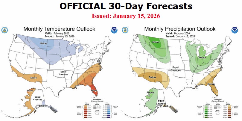
According to the National Oceanic and Atmospheric Administration, February favors below-normal precipitation across much of the western U.S., including California. Northern California’s forecast becomes murkier after Feb. 10, when some models suggest the ridge may weaken, allowing colder systems from the northwest to brush the region. These storms tend to be low on moisture, meaning limited rain and snow even if they arrive.
Southern California is expected to stay drier than normal well into mid-month, and possibly beyond. La Niña is weakening, which adds uncertainty later in February, but current signals still point toward a dry finish.
Recent history suggests February often swings between extremes. This year is shaping up to land on the dry side, with any meaningful snowpack recovery likely dependent on a late-month storm that has yet to materialize.