
Northern California forecast: Cloudier with a few regional showers this Wednesday
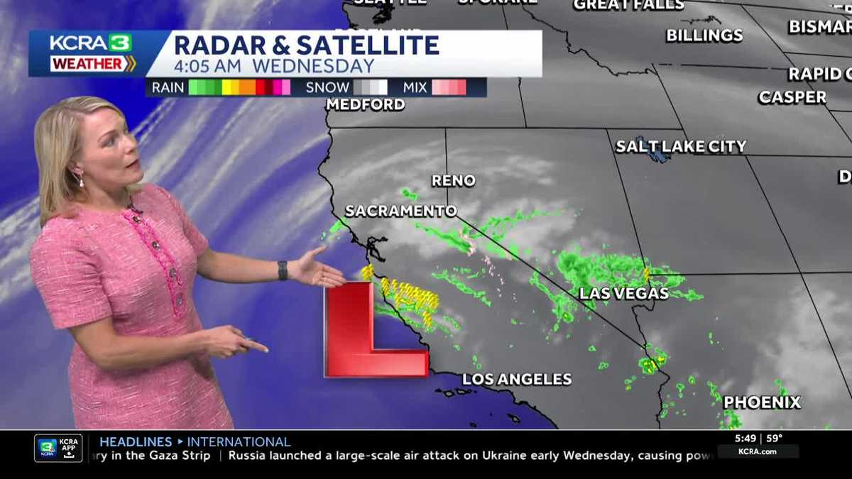
We are noticing increasing clouds this morning thanks to a weak system moving up from Southern California.
IT FEELS A BIT MORE FALL-LIKE, ESPECIALLY AS WE HEAD INTO TODAY. YOU’RE GOING TO FEEL THE TRANSITION BECAUSE WE’RE SEEING THE CLOUD COVER OUT THERE. WE’LL FEEL THE DROP IN TEMPERATURES, AND YOU’LL NOTICE THE COOLER AIR ALREADY STREAMING IN. HERE’S A LIVE LOOK OUTSIDE FROM STOCKTON, AND YOU CAN SEE THE VISUAL, THE CLOUD COVER, AND ALSO THAT FLAG. GETTING A NICE LITTLE BRUSH UP ALONG THE HORIZON. THANKS TO A STEADY NORTHWEST WIND IN THE STOCKTON AREA AND MORE OF A WEST TO SOUTHWEST WIND, IF YOU’RE WAKING UP AND JOINING US IN SACRAMENTO 59 DEGREES RIGHT NOW, SACRAMENTO AND STOCKTON 60 OUT THE DOOR MODESTO AND 40 IN LAKE TAHOE AND UNDERNEATH THE CANOPY OF CLOUDS HAVE BEEN SEEING THE OCCASIONAL SHOWER. AGAIN, MOST OF THIS PRETTY MUCH BROKEN APART, AND MOST OF THESE SHOWERS HAVE BEEN ON THE VERY, VERY LIGHT SCALE. DOPPLER INDICATING THAT EVEN HERE AROUND MAGALIA INTO FEATHER FALLS AND AROUND PARADISE, YOU’VE HAD A COUPLE OF LIGHT SHOWERS IN THE EASTERN HALF OF BUTTE COUNTY AND THEN AROUND THE PORT AND INTO PARTS OF SIERRA AND NEVADA COUNTIES. A COUPLE OF ISOLATED SHOWERS, AND THEN MOST OF THIS ACTIVITY AROUND HIGHWAY 50 STRETCH AND INTERSTATE 80 HAS BEEN VERY LIGHT. A FEW SPRINKLES AT THAT AND THEN SOME BETTER LIGHT RAIN SHOWERS HERE AS YOU GET EAST OF ARNOLD. GOING UP ALONG HIGHWAY FOUR. RADAR SATELLITE SWEEP. THIS IS THE BIG PIECE OF THE STORY TODAY. THIS PIECE OF ENERGY, WHICH IS ALSO GENERATING SOME THUNDERSTORMS FROM THE CENTRAL COAST AND INTO PARTS OF THE COASTAL AREAS THERE OF SANTA BARBARA AND PASO ROBLES AREA. THAT’S WHERE THERE’S A LOT OF LIGHTNING STRIKES. NOW, I’M NOT GOING TO RULE OUT THE CHANCE OF MAYBE AN ISOLATED SHOWER OR THUNDERSTORM, ESPECIALLY TODAY IN STANISLAUS COUNTY AND IN TUOLUMNE COUNTIES. I THINK THOSE WILL BE THE FOCAL POINTS, AT LEAST IN OUR REGION, AS WE GET THROUGH THE MORNING HOURS. DON’T BE SURPRISED IF YOU HAVE SOME RAIN HIT THE WINDSHIELD WITH THAT MORNING COMMUTE. SEVEN EIGHT, 9:00 TODAY. NOW BEYOND 10:00, MOST OF THE VALLEY IS GOING TO DRY OUT WITH THE EXCEPTION OF STANISLAUS COUNTY. TUOLUMNE COUNTY COULD HEAR A RUMBLE OF THUNDER INTO THE AFTERNOON. AND THEN MOST OF THIS ACTIVITY WINDS DOWN AS WE GO THROUGH THE EVENING. AS THIS SYSTEM TRACKS TO THE EAST. HIGH PRESSURE BUILDS IN, BUT IT IS GOING TO BE PREMATURE AS WE GET INTO THE WEEKEND. WE’VE GOT A WEATHER SYSTEM GETTING READY TO MOVE IN HERE SATURDAY. NOW SATURDAY LIKELY TO BE THE DAY THAT WE HAVE SCATTERED SHOWERS INTO THE AREA. SOME LIGHT SNOWFALL ABOVE 8000FT. THEN SUNDAY. AT THIS POINT, THIS MODEL AT LEAST DRIES US OUT BEFORE THE RETURN OF MORE RAIN, POTENTIALLY OVERNIGHT SATURDAY. EXCUSE ME, SUNDAY INTO MONDAY. WE’RE NOT GOING TO NET A LOT OF RAINFALL. WE’RE TALKING MAYBE A 10TH TO A QUARTER OF AN INCH. AND FOR THE SIERRA SEVEN DAY FORECAST, AGAIN, OUR BEST SHOT AT SNOW IS GOING TO BE AT ELEVATIONS ABOVE 8000. SATURDAY CLOSER TO AROUND THAT 6000 FOOT LEVEL ON SUNDAY. NOW THE FOOTHILLS FORECAST IS GOING TO BE A LITTLE DAMP ON SATURDAY, MUCH LIKE WE’RE GOING TO SEE HERE IN THE VALLEY AND LOOK AT THE TUMBLE. AND TEMPERATURES ARE GOING TO GO FROM MID 70S TO END THE WORKWEEK, DROP BACK TO THE 60S THROUGHOUT THE WEEKEND. SO BOTTOM LINE, I WOULDN’T CANCEL OUTDOOR PLANS, LET’S SAY SATURDAY. BUT THE FORECAST DETAIL WILL BE FINE TUNED AS WE GET MORE DETAILS. I’M GOING TO A WEDDING IN SEATTLE. IT WAS SUPPOSED TO BE OUTDOORS, AND THAT’S WHERE THE ATMOSPHERIC RIVER IS GOING TO GO. BAM, BAM. SO RAIN IS SUPPOSED TO BE LUCKY ON YOUR WEDDING DAY? IS IT OKAY? WELL, THE
Northern California forecast: Cloudier with a few regional showers this Wednesday
We are noticing increasing clouds this morning thanks to a weak system moving up from Southern California.

Updated: 6:15 AM PDT Oct 22, 2025
We are noticing increasing clouds this morning thanks to a weak system moving up from Southern California.Sprinkles are possible in the valley, with higher chances of showers and a possible thunderstorm in the Sierra, mostly south of Highway 50.Most of the region will see clouds, which will cap valley highs in the low 70s. Highs in the foothills will be in the mid to upper 60s, with Sierra highs in the low 60s.The quick-moving system shifts east by evening, and Thursday looks sunnier and warmer, with valley highs in the mid-70s.Friday will be pleasant overall, but cloud cover will return as we prepare for a wetter system.This weekend’s system may bring rain as early as Saturday morning. Expect a few showers as the first band of moisture pushes through Saturday afternoon. A quiet, windy Sunday is expected, with just a few valley showers, before a second band of moisture may sweep through Monday morning.In the Sierra, snow levels will remain high—starting near 8,000 feet and dropping to around 7,000 feet on Sunday—potentially impacting passes.Weather is expected to clear through Monday, with drier, sunnier conditions returning Tuesday.
SACRAMENTO, Calif. —
We are noticing increasing clouds this morning thanks to a weak system moving up from Southern California.
Sprinkles are possible in the valley, with higher chances of showers and a possible thunderstorm in the Sierra, mostly south of Highway 50.
Most of the region will see clouds, which will cap valley highs in the low 70s. Highs in the foothills will be in the mid to upper 60s, with Sierra highs in the low 60s.
The quick-moving system shifts east by evening, and Thursday looks sunnier and warmer, with valley highs in the mid-70s.
Friday will be pleasant overall, but cloud cover will return as we prepare for a wetter system.
This weekend’s system may bring rain as early as Saturday morning. Expect a few showers as the first band of moisture pushes through Saturday afternoon. A quiet, windy Sunday is expected, with just a few valley showers, before a second band of moisture may sweep through Monday morning.
In the Sierra, snow levels will remain high—starting near 8,000 feet and dropping to around 7,000 feet on Sunday—potentially impacting passes.
Weather is expected to clear through Monday, with drier, sunnier conditions returning Tuesday.