

Presidents Day was greeted by thick gray clouds and rainfall across the Bay Area Monday as the first of three back-to-back storms brought minor flooding to some parts of the region, with steady rain expected to continue Tuesday and even the possibility of mountaintop snow by Wednesday.
The first storm, which arrived Sunday and brought its heaviest rainfall overnight into early Monday morning, dumped the most rain on the North Bay and coastal mountains, said National Weather Service meteorologist Matt Mehle. A second storm touches down on Tuesday.
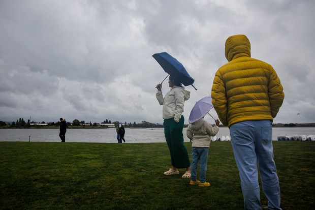 Chandani Chordiya, left, of Milpitas, her husband, Rohan, right, and their daughter, Sanshrita, 5, visit Shoreline Lake in Mountain View, Calif., as a storm soaks the Bay Area on Monday, Feb. 16, 2026. Chandani said the rain brings back fond memories of dancing in the rain as a child in India. (Dai Sugano/Bay Area News Group)
“We’re not completely done yet,” Mehle said. “This storm door does remain open, and we’ve got another frontal passage that will bring additional rainfall Tuesday and Wednesday, and then we actually have a third system that’s going to round out the work week, Thursday to Friday, with additional rain chances.”
“It’s going to be a wet week,” he added.
All three storms bring a chance of low-level flooding, with a coastal flood advisory in place for the San Francisco Bay through Tuesday. It will primarily pose an issue for those driving or traveling, who may run into some water on the roadways, said NWS meteorologist Dalton Behringer.
“If you want to see flooding, you’ll have to go find it,” he said. “It’s not going to find you.”
By Monday afternoon, San Jose had received an inch and a half of rain since the beginning of the storm Sunday, said NWS meteorologist Brayden Murdoch. Oakland got just over an inch, while Livermore received one inch and San Francisco saw 1.36 inches. The Santa Cruz Mountains received two inches with some higher peaks surpassing four inches.
Behringer noted that while Monday’s downpour might have caught some Bay Area residents off-guard, the rainfall totals were looking “on par with what was forecast.”
“We are seeing some variability when it comes to rainfall, but ‘solid soaking rain’ is a good way to describe it for most of the Bay Area,” Mehle said.
 A pedestrian uses an umbrella to shield away rain drops as she walks along Tennyson Road on Monday, February. 16, 2026 in Hayward, Calif. Wet weather is forecast across the Bay Area over the next several days. (Aric Crabb/Bay Area News Group)
Though the storm passing through the region Monday is expected to be the wettest of the three, the second storm will come close to its rainfall totals, Mehle said. The third storm is expected to drop the least precipitation. The storms will also bring colder air that will drop temperatures in some areas, including San Jose, to the high 30s and low 40s.
The second storm is forecast to touch down in the North Bay before spreading through the rest of the Bay Area around sunrise on Tuesday, Behringer said. The afternoon will see heavier, isolated showers, with totals projected to be between a half-inch and an inch across the region.
There are also chances of thunderstorms through midday, as well as a chance of small hail at lower elevations.
The storm Tuesday also brings a winter weather advisory for the eastern Santa Clara Hills lasting until Wednesday afternoon, due to snow at elevations over 3,000 and a potential dusting of snow below that, according to a NWS warning. Snow may impact road conditions on Highway 130 and hiking trails.
“People who are traveling over that path will definitely run into some snow impacts around Mount Hamilton,” Behringer said. “People in San Jose can expect to wake up and look east and see the snow capped hills.”
For the first time this season, Bay Area residents will likely be able to see snow on the Diablo and Santa Cruz mountains as well, Mehle added.
A coastal flood advisory was put in place for the San Francisco Bay through Tuesday due to the potential of up to a foot of high tide flooding in low-lying areas, according to NWS. The California Highway Patrol reported some minor roadway flooding in Redwood City Monday that didn’t have much impact, Mehle said. Further flooding was reported in Monterey County.
“The creeks and streams are filling out. The culverts are kind of full and running pretty solid,” Mehle said. “The way to describe this would be more minor or nuisance-style flooding.”
Low-level flooding is expected to continue throughout the week, though the region is “still in pretty good shape,” Behringer said.
“Because we had such a big dry spell mid-winter … we may notice some small rises in the rivers, but we’re not going to have any river flood problems,” he said.
The third storm arriving in the Bay Area on Thursday is expected to drop between one-quarter and three-quarter inches of rain across the region, with more scattered showers than deluge, Behringer said.
Travelers heading to or from Lake Tahoe should check road conditions and take proper winter equipment. A storm that is expected to last through Wednesday was already causing slow downs and closed roads Monday, with snowfall projected to be between two and three feet in the Tahoe Basin and between three and five feet at elevations above 7,000 feet, said NWS meteorologist Edan Lindaman.
Winds were strong enough Monday that some ski resorts put out wind holds, she added. Low visibility is expected due to the combination of the snow and wind. A second storm arriving in the region Thursday is expected to extend road impacts through most of the week.
“It makes it very dangerous to drive or to be kind of in those mountain areas,” she said.