
Profuse snow over the many of the California mountains into Thursday night will hinder travel with more snow to take aim at Northern California and begin in part of Oregon starting later this weekend.
Published Feb 17, 2026 10:47 AM CST
|
Updated Feb 19, 2026 8:56 AM CST
From shutdowns of mountain passes to deadly avalanches, extreme snowfall in the mountains of California has caused widespread problems—and more is on the way.
Widespread rounds of mountain snow in California will continue through Thursday night, with additional pass closures. As yet more storms roll in from the Pacific, they will focus on the mountains of Northern California and expand over Oregon and Washington through nearly the end of February.
A long train of storms stretches across much of the North Pacific.
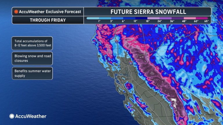
“When this pattern finally wraps up late next week, parts of the Sierra Nevada will end up with 12-16 feet of snow,” AccuWeather Chief On-Air Meteorologist Bernie Rayno said.
While that amount of snow may be good for future spring and summer runoff into reservoirs and streams, it poses dangerous short-term problems.
A vehicle is buried in snow during a storm on Tuesday, Feb. 17, 2026, in Truckee, California. (AP Photos/Brooke Hess-Homeier)
For a time on Monday, Interstate 80 over Donner Summit, California, was closed. Tuesday night, the highway was once again closed from Colfax, California, to the Nevada state line. Interstate 80 over Donner Summit has reopened as of Wednesday night; however, additional closures are possible through Thursday. Snowfall rates of 2 to perhaps 4 inches per hour can easily overwhelm road crews, leaving motorists stranded.
As of Wednesday, there has been just over 5 feet of snow over Donner Pass from the storm. Snowfall totals over the past 72 hours as of early Thursday morning were mainly between 55 and 70 inches in the northern and central Sierra Nevada, with more on the way.
Another storm will pivot through California Thursday and Thursday night with more bursts of heavy snow for the Siskiyous and Sierra Nevada in the northern and central parts of the state, as well as the various ranges in Southern California. In total, through Thursday night, from 1 to as much as 6 inches of snow can pile up over the Southern California passes, with up to a few feet of snow over the ridges and peaks.
“Along with the obvious problems from heavy rates of snow will be the potential for avalanches through the passes and in the high country,” AccuWeather Meteorologist Alyssa Glenny said early Tuesday morning. When snow rapidly accumulates on steep terrain, it can become unstable and give way without warning.
On Tuesday, an avalanche trapped a large group of skiers in the Northern California backcountry, with at least eight fatalities reported by Wednesday evening, according to CNN.
Rain and localized flooding are likely in the lowest elevations near the coast and in the valleys.
In the lower south- and west-facing hillsides of the Sierra Nevada and the Transverse Ranges, from 4-8 inches of rain in total is forecast with an AccuWeather Local StormMax™ of 9 inches. Both Los Angeles and San Francisco can expect a multiple-day storm total of 2-4 inches.
Since the new rain year began on Oct. 1, downtown Los Angeles has received 16.99 inches of rain compared to a historical average of 9.26 inches through Feb. 17. This is nearly twice the average rainfall.
Have the app? Unlock AccuWeather Alerts™ with Premium+
Enough rain has already fallen and resulted in incidents of flash flooding at lower elevations in many major California cities, from San Francisco to Los Angeles and San Diego. Each subsequent storm through Thursday will raise the risk of mudslides and other debris flows. Hillsides made unstable by the rain could slip. Road washouts are possible.
As that storm moves over the interior Southwest Friday, a shift in the storm track will favor little to no rain and mountain snow in Southern California, as well as ongoing precipitation for Northern California and the Northwest starting later this weekend through much of next week.
Rounds of snow will occur across the Cascades in Oregon and Washington, as well as additional periods of snow for the Siskiyous and the northern Sierra Nevada in California.
One of the storms next week may develop a long plume of moisture from the tropical Pacific, or an atmospheric river.
This could gradually direct heavy rain and mountain snow farther to the south over much of California once again.
Want next-level safety, ad-free? Unlock advanced, hyperlocal severe weather alerts when you subscribe to Premium+ on the AccuWeather app. AccuWeather Alerts™ are prompted by our expert meteorologists who monitor and analyze dangerous weather risks 24/7 to keep you and your family safer.