
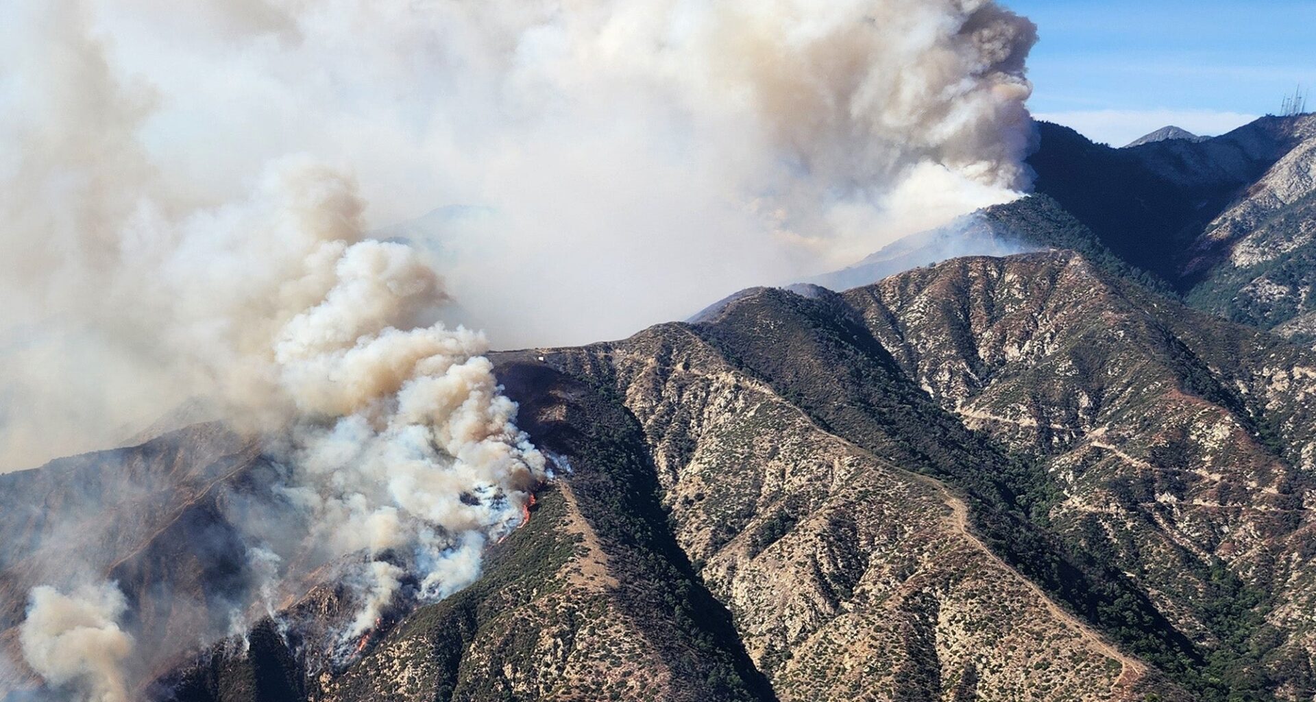
The 2025 Eaton fire’s smoke did more than darken the sky: It generated a carbon monoxide and particulate matter surge that far exceeded Los Angeles County’s average daily human-caused emissions, according to a new study led by researchers at the USC Dornsife College of Letters, Arts and Sciences.
Why it matters: The findings show how a major urban wildfire can quickly become a regional air-quality crisis, sending harmful smoke across L.A. and raising concerns about respiratory, psychological and other health effects that Keck School of Medicine of USC researchers are now studying.
What they found: Researchers estimated the Eaton fire produced carbon monoxide at rates more than 20 times higher than L.A. County’s average daily human-caused emissions.
“People could see the smoke, but they couldn’t see the scale of the pollution it was carrying,” said William Berelson, professor of Earth sciences, environmental studies and spatial sciences at USC Dornsife and a co-author of the study. “This one fire was producing carbon monoxide on a scale that exceeded the entire county’s usual daily emissions from human activity.”
Zoom in: Burning homes and other structures accounted for a larger share of the fire’s carbon emissions than trees and shrubs did, helping explain why the Eaton fire created such a large regional impact.
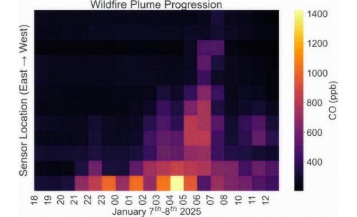 Data analysis of Eaton fire smoke shows how carbon monoxide levels increase across Los Angeles from east to west over the first two days. (Image source: ACS ES&T Air.)
How they did it: Researchers combined satellite imagery, computer-aided modeling of the smoke plumes and on-the-ground air measurements to estimate what burned and track how smoke moved across the region in near real time.
The air data included readings from the Carbon Census network of sensors deployed around Los Angeles by Berelson’s team.
By the numbers: The team estimated the Eaton fire released about 153 million kilograms of carbon (337 million pounds).
Smoke reached downtown L.A. within hours of the fire’s start, then moved west, reaching coastal areas several hours later.
At some monitoring sites, levels of harmful fine-particle pollution known as PM2.5 exceeded the EPA’s 24-hour health standard for one to three days.
The big picture: The January 2025 Los Angeles fires affected the region in different ways, but the Eaton fire stands out because its smoke moved directly into central and western Los Angeles, exposing communities far from the burn area.
By contrast, early emissions from the Palisades fire were carried offshore by winds.
What it means: The study suggests urban wildfires should be understood not only as disasters of flame and loss, but also as citywide air-quality emergencies with climate and public-health consequences.
The findings could help scientists and policymakers better estimate the full costs of urban fires, including emissions and air-quality impacts that spread across an entire metro area.
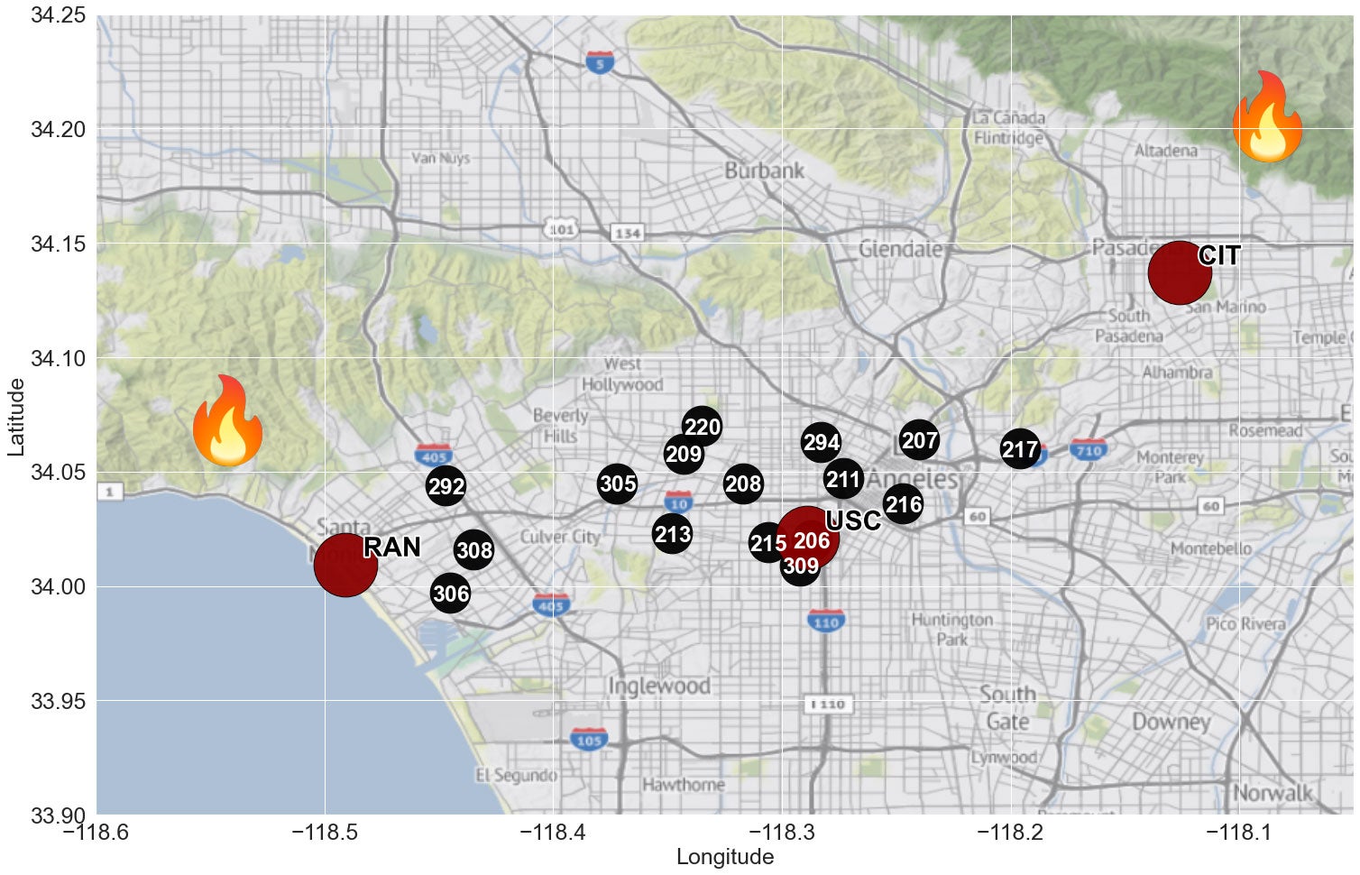 A map of L.A. shows Carbon Census (black) and Los Angeles Megacity Carbon Project (maroon) node locations as well as where the Palisades (left) and Eaton (right) fires broke out. (Image source: ACS ES&T Air.)
About the study
In addition to Berelson, study authors include Pietro Vannucci and Wenye Wang of USC Dornsife and Jooil Kim and Timothy Lueker of Scripps Institution of Oceanography, University of California, San Diego.
The research was supported by USC through a President’s Sustainability Award and a USC Dornsife Public Exchange Grant.