
This week’s California heat wave, dubbed a “marathon,” is approaching the midpoint — somewhere between milepost 10 and 13. The most grueling stage is yet to come.
March temperature records will continue to be threatened statewide through Friday before a slight reprieve over the weekend. But it’s all relative. Much warmer-than-normal weather will continue for at least another week.
Only minor temperature fluctuations are expected Wednesday and Thursday along the coast and in the Central Valley as readings push toward monthly records. San Francisco may cool a degree or two from Tuesday, but it’ll hardly make a difference. The Sierra Nevada and Mojave Desert will warm up with each passing day. True summerlike heat is expected in both areas, in the 70s and 100s, respectively.
Friday will probably be the hottest day of the week across the state. That’ll present San Jose’s best shot of reaching 95 degrees and open the door for San Francisco and Oakland making another run at 90 degrees. Palm Springs could even reach 110 degrees.
Coastal heat advisories and warnings are set to expire at 8 p.m. Friday.
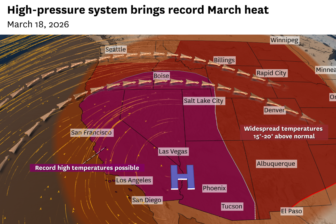
The high-pressure system will shift east over the weekend, keeping the Desert Southwest, southern Rocky Mountains and Great Plains under intense heat. The system’s movement will promote a stronger sea breeze Saturday, cooling San Francisco and Los Angeles to the 70s and 80s, respectively. Those highs are still about 10 degrees above average in each city.
“The most intense heat will begin to wane somewhat … but highs are expected to still remain well above normal compared to March climatology,” the National Weather Service said.
Warm and dry weather is favored through the end of March. Only far Northern California is forecast to be brushed by light precipitation next week, with low odds for significant rain or snow anywhere south of Interstate 80.
San Francisco: Well above-normal temperatures will continue, though Wednesday may be slightly cooler than Tuesday. An earlier arrival of the sea breeze should keep the outer Richmond and Sunset districts in the 70s and the inner areas in the low 80s. Downtown should reach the mid-80s. Overnight lows will be warm, in the mid- to upper 50s west of Twin Peaks and low 60s to the east, with hills above 500 feet remaining in the upper 60s.
North Bay: The brunt of the heat wave will continue as Wine Country highs climb well into the 80s, with low 90s in eastern Solano County and northern Sonoma and Napa counties. A sharp temperature gradient is expected along the coast, in the upper 60s at the beach, 70s a few blocks away and 80s a mile inland. Overnight lows will range from the upper 50s to low 60s in the valleys to the mid-60s to mid-70s about 500 feet in elevation.
East Bay: High temperatures will soar toward 90 degrees in Antioch, Brentwood, Concord, Walnut Creek, Danville, Dublin, Livermore, Hayward and Fremont. A very shallow marine layer should keep Oakland in the upper 80s and Richmond, Berkeley and Alameda in the mid-80s. Overnight lows will be in the upper 50s to mid-60s along the bay shoreline and in the interior valleys, while the Oakland and Berkeley hills will be in the upper 60s to low 70s.
Pacific Coast and Peninsula: Temperature contrast between the coast and bayshore cities will be more pronounced than recent days, as slight cooling is anticipated at the beaches while highs remain steady along the Highway 101 corridor. Daly City, Pacifica and Half Moon Bay will probably see their highs around noon, in the 70s, before a weak sea breeze drops temperatures to the 60s in the afternoon. South San Francisco, San Mateo and Redwood City should warm to the upper 80s. Overnight lows will be in the upper 50s to low 60s.
South Bay and Santa Cruz: Another record hot March day is on tap for the South Bay as temperatures surge to the low to mid-90s. Upper 90s are possible in Boulder Creek, Ben Lomond and Gilroy. A weak breeze off Monterey Bay should keep highs in the mid-80s in Santa Cruz, slightly cooler than earlier this week. Overnight lows will range widely, from the upper 40s to low 60s in the valley to the mid-60s to mid-70s in the mountains.