
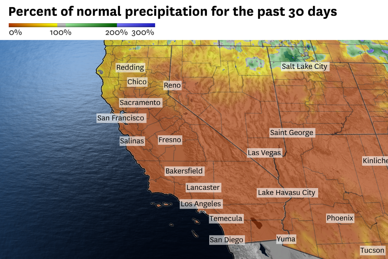
Little to no precipitation has fallen in Central and Southern California since late February, with only light totals in Northern California.
Baron/Lynx
California’s herky-jerky wet season is at an inflection point.
There has hardly been any rain this month, and the mountain snowpack is melting at a startling rate, which means drought could return by summer.
But the wet season isn’t entirely over.
Article continues below this ad
Weather models are arriving at a consensus: California’s next chance of precipitation will come as March ends and April begins. It’s not a guarantee, as the start of the stormy window is still a week away, but it appears to be the best shot of widespread rain and snow in nearly six weeks.
California hasn’t seen the end of the massive high-pressure system that’s dominated much of the Western U.S. for the past two weeks, driving temperatures up. It’ll stick around for at least five more days and threaten more temperature records in Central and Southern California.
San Francisco Chronicle Logo
Make us a Preferred Source to get more of our news when you search.
Add Preferred Source
By Sunday, though, the area of high pressure should finally begin to shift eastward. That shift will promote a monsoon-like pattern in Arizona, as a surge of moisture from the south increases thunderstorm chances Sunday and Monday.
The National Weather Service in Phoenix advised of increased rain prospects this weekend from a “quasi-monsoon” pattern.
National Weather Service
That moisture probably won’t make it to California. But the departure of the high-pressure system will open the door for Pacific storms to nudge toward the state. It’s too early to provide forecast precipitation totals, but anywhere from the Oregon-California border to the Mexico border could see rain midweek, including San Francisco, Sacramento and Los Angeles.
Article continues below this ad
A broad area of low pressure over the eastern Pacific Ocean could bring rain and snow to California as March ends and April begins.
Baron/Lynx
Snow in the Sierra Nevada is a possibility, too. Systems swinging across California may draw upon cold air from near Alaska, where a lengthy sub-freezing spell is rivaling the longest stretches on record.
It’s hard to put much stock into precipitation predictions seven days out. But the jet stream, a ribbon of fast-moving air high in the atmosphere, also known as the storm track, still carries enough energy through spring to bring wet weather to California. San Francisco averages more than an inch of rain in April and Tahoe typically receives more than a foot of snow.
The window for precipitation will probably last for five to seven days. Drier weather is predicted to return thereafter, according to the Climate Prediction Center branch of the National Weather Service.
But even if storms dropped feet of snow, California’s snowpack will still be well below normal.
Article continues below this ad
Daniel Swain, a climate scientist at UC Agriculture and Natural Resources, called it “statistically and meteorologically impossible for a substantive recovery to happen between now and summer.
Weather service officials in a Monday webinar echoed Swain’s sentiment, saying typical spring precipitation is dwarfed by October through March amounts. Though any rain and snow would be welcomed, the weather service said.
“It’s better than nothing, especially as the rainy season is winding down,” the agency’s Bay Area office wrote in an online forecast.
Tuesday breakdown
San Francisco: Another 70-degree day is expected downtown and temperatures as high as the upper 70s are possible in the Mission District, Noe Valley, Portola and Dogpatch. Cooler weather will prevail west of Twin Peaks, where highs will be in the 60s to low 70s. Westerly winds gusting up to 15 mph are expected in the afternoon. Overnight lows will be in the low 50s with increasing moisture making fog possible, especially in the hills and near the beaches.
Article continues below this ad
North Bay: Patchy morning fog is possible along Highway 101 in Sonoma County, but otherwise it’ll be a sunny day. Temperatures are expected to soar back into the low 80s in Santa Rosa, Napa and Vallejo and as high as the mid-80s in Fairfield and Vacaville. Petaluma and San Rafael should be relatively cooler, in the upper 70s, but still well above what is typical in late March. Coastal areas will be in the 60s. It’ll be mainly clear overnight with lows in the mid-40s to low 50s, but fog may form just before sunrise along the coast.
East Bay: Another sunny and warmer-than-normal day is expected. The Caldecott Tunnel marks the dividing line between 70-degree and 80-degree temperatures. Oakland, Berkeley, Hayward and Fremont will probably be in the mid- to upper 70s, while Walnut Creek, Concord, Danville, Dublin, Livermore and Pleasanton reach the low 80s. The afternoon sea breeze will bring gusts up to 15 mph, except in Livermore Valley, where gusts up to 20 mph are possible. Overnight lows will be in the upper 40s to low 50s.
Pacific Coast and Peninsula: Sunny skies will prevail along the coast with highs in the low 60s at the beaches and the mid- to upper 60s away from the water in Daly City, Pacifica and Half Moon Bay. Low 70s are expected in San Bruno and South San Francisco with mid- to upper 70s in San Mateo and Redwood City. Gusts of 10 to 20 mph are likely in the afternoon. Overnight lows will be in the low 50s, with a chance of patchy fog by dawn Wednesday.
South Bay and Santa Cruz: San Jose will flirt with 80 degrees again while a light bay breeze should keep Milpitas, Mountain View, Sunnyvale and Santa Clara in the upper 70s. Temperatures may reach the mid-80s in Cupertino, Campbell, Morgan Hill, Gilroy, Scotts Valley and Boulder Creek. Northwest gusts up to 20 mph are expected in the afternoon and early evening. Overnight lows will be in the upper 40s to low 50s.
Article continues below this ad