
California and much of the Western United States has been drying out this month.
An unseasonable streak of warm weather has broken temperature records, pushing highs into the 80s and 90s. The small community of North Shore in Riverside County even tied the record for the highest March temperature ever recorded in the U.S., hitting 108 degrees last Wednesday.
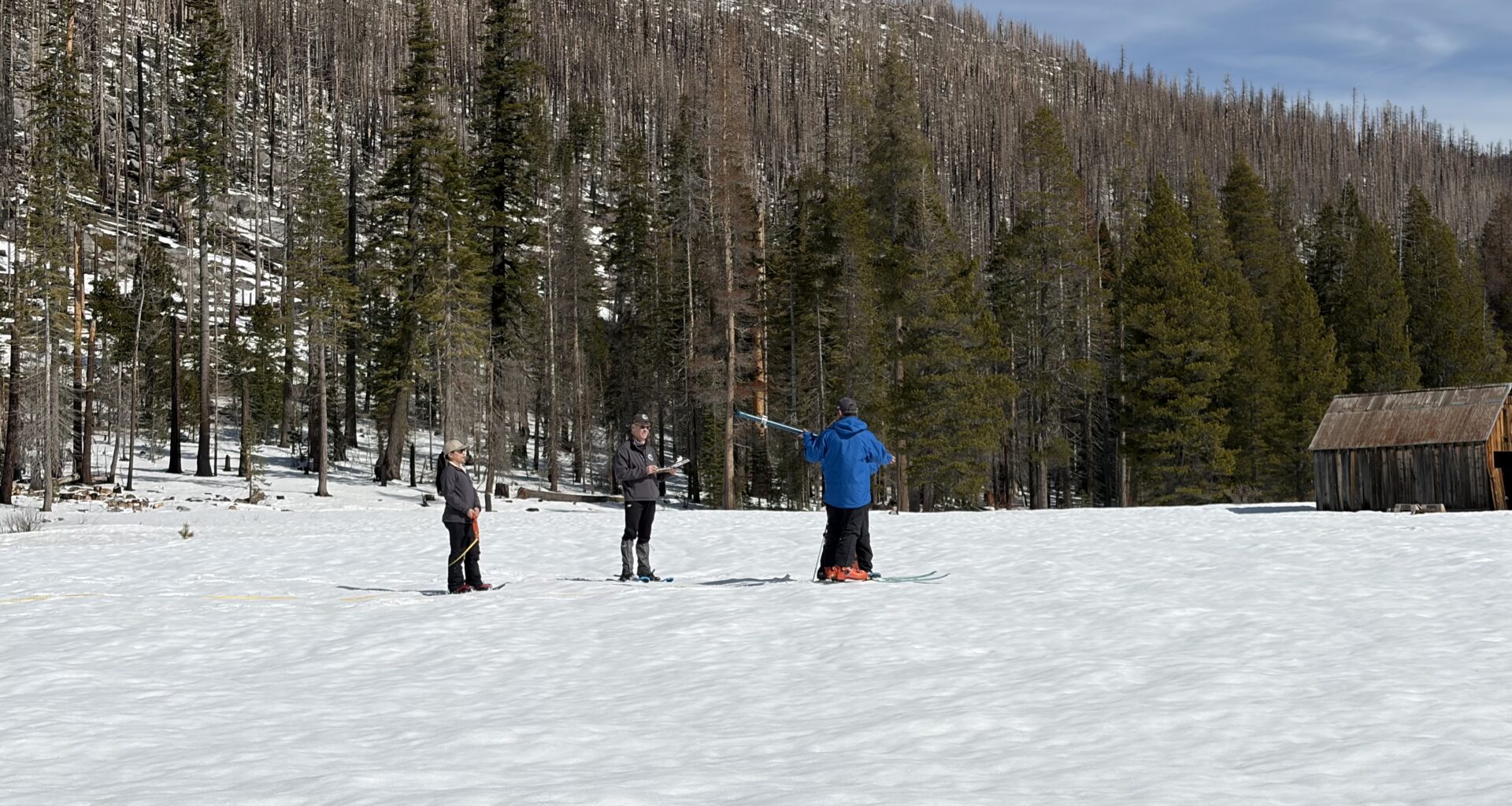
This heat is raising concerns, particularly for those monitoring California’s snowpack in the Sierra Nevada which supplies about a third of the state’s water supply. Officials from the Department of Water Resources said last week the statewide snowpack has been melting at an average rate of 1% per day.
This could put California on track to experience a near record-low measurement on April 1, historically when the snowpack has been at its peak.
KCRA Meteorologist Tamara Berg and California State Climatologist Michael Anderson spoke with CapRadio’s Laura Fitzgerald on Insight about what the short-term and long-term impacts of this unseasonable heat could be.
These interviews have been edited for length and clarity.
Interview highlights
Why has it been so hot? What’s been driving these conditions?
BERG: You probably have seen a lot of the headlines, and one of the major things that’s been trapping the heat in the Sacramento Valley has been this heat dome. There’s this big dome of high pressure and it’s basically camping out over Northern California. It’s like if you were boiling water on your stovetop and then you put a lid on top of it, where’s the heat go? It all just stays in the same place. That’s exactly how we got started in this heat, and the extended heat spell that we saw starting back on March 15.
What do March temperatures usually look like in the Sacramento region, and what have the highs been looking like during this spell?
BERG: The seasonal normal for the month of March is typically about 65 degrees, and that goes up a little bit as we get toward the end of the month. But now because of just how warm it’s been and unseasonably warm, the average high now — if we were to end March today — would be 77.2 degrees. That’s way above where we should be.
Has Sacramento had a streak of unseasonably warm weather like this in recent years?
BERG: Yeah, it’s not uncommon to see a stretch of very, very warm conditions. Different areas, different regions of the state have different definitions of what a heat wave is. Now, a heat wave is typically anytime temperatures jump above normal by a certain degree extent. Sure, we’ve been above normal but the threshold for Sacramento, you have to be 100 degrees for three consecutive or more days. We have not hit 100.
So when people think about summer heat, that’s when you start to think [of] the term heat wave. This has just been an unseasonably stretch of warm weather.
Have we set or broken any temperature records with this hot spell we’ve seen this month?
BERG: We certainly have. Going all the way back to March 15, that’s when things really kicked off, we actually tied the record that day. We actually did see the all-time hottest March day in Sacramento tied — that went back to Wednesday, March 18 at 88 degrees. We also did it again on March 20, hitting 88 degrees.
Now there were chances that we could have [gone] to 90 last week. We didn’t go there; if we’d done that, that would have ultimately smashed the all-time March record in Sacramento.
What does the upcoming forecast look like?
BERG: For the next seven days in my forecast temperatures are easing down, but we’re still running above normal. Last week we had some of those records that were 20-25 degrees above normal. This week we’re looking at those going 10-15 degrees above normal. So still unseasonably warm. I just don’t think we’re going to break as many records this week as we did last week. And the trend is going downward, especially from the weekend and into next week.
Are rain and snow still a possibility this month?
BERG: I think probably for March we’re going to close the door on that, but maybe as we set up into April, the longer range models that I look at [do] have potential for some rain and high elevation snow, potentially from the first of April through about April 4. Now again, as meteorologists we always talk about that being kind of the “fantasy range.” We just have to see those models kind of hold together and hopefully if we can get this dominant ridge of the heat influencer out of here and get those storms to come in, we would start to see a turn [in] April.
Is this any indication of what the summer could look like?
BERG: I’ve had a lot of folks come to me in the grocery store or just out and about and they think, “this is setting us up for an atrocious summer.” We can’t go off of this. This is just an unusually warm period in March. We have seen in climate history, things happen like this before and then we can see a big turn of events. I would not be putting money on the summer being unseasonably warm all [season] long.
What safety tips or reminders should people keep in mind when spending time outdoors, especially in the heat?
BERG: There’s a lot of construction, you see a lot of folks that are out there in the direct sunlight. You want to be in the light-colored loose-fitting clothing that’s breathable, cotton breathes easier on the body. Hydration — we have to remind ourselves not only daily to drink water, but when it is a little bit overly warmer than normal you should probably be drinking more of it. Those electrolytes are important.
And then also strenuous activity. You want to limit that activity outside, and try to do things when it’s cooler in the day versus the heart of the afternoon.
A one-year blip, or a multi-year spell?
How unusual has this year been?
ANDERSON: What we’ve seen are a lot of dry days through our wet season, interrupted by some rather punctuated storm activity. This year it started in October; we actually had an on-time start to our water year. We haven’t had that in recent years. Then we had a really good storm in November that had some really interesting components to it, including the remains of some moisture from an East Pacific hurricane that really dumped a lot of rain in parts of Southern California.
We had flooding during Christmas week with heavy rains. But boy, in the new year, not a whole lot. We did have the cold storm in February dumping a lot of snow, but right on its heels was a warm storm in Northern California that really moved the snowpack from a stable state into a state ready to melt. When the dry, warm weather showed up, the snow melted rapidly.
Last year California saw average or cooler-than-normal conditions, but this year we’re baking under record heat. What causes those yearly swings so quickly?
ANDERSON: A number of contributing factors. One includes the Pacific Ocean… ocean conditions really help set up the weather circulation, where we see high and low pressures form. This winter it’s been set up so that we’ve had that high pressure on our doorstep or overhead. Only a few times has it backed off and that’s allowed those storms to come in.
As we move into summer we have those opportunities for these types of conditions where high pressure sets in, you get heat building up under it that doesn’t have a chance to dissipate.
Officials said last week that California’s snowpack is melting at an average rate of 1% per day. What do the current conditions look like?
ANDERSON: That is still holding. Today [Monday] we are down to 29% of average of what we would expect on this date. That’s getting close enough to April 1… of what would be our normal peak snowpack.
In 2015 California’s lowest-recorded snowpack was at just 5% of average. Are we facing the same conditions this time?
ANDERSON: No. 2015 was really a unique year in that the snow really never got a chance to accumulate. We had two really big warm storms, one in December [and] one in February, but otherwise really didn’t get much precipitation at all, so no snowpack really formed.
This year we’ve had the wet weather, we’ve had snow on the ground. It’s just melting early because of that warm storm getting the pack ready to melt, and then a lot of sunshine and heat to get it going and continue. While we’re not likely to get down to that 5% statewide, we’ll be in the neighborhood of the next two in our record book and that was 2014 and 1977 when we were only 25% of average.
In January the state was declared drought-free for the first time in 25 years. But given the current conditions, could another drought be on the horizon?
ANDERSON: [It’s] hard to tell with California because of that wild year-to-year variability. However, usually if you go back and look at our droughts and we see that first dry year, this one has a lot of characteristics that set up like that. We look at where we’re at this year, where the snow’s melted early but reservoirs are above average in storage, and past wet years have given us a little buffer in our groundwater system.
We’ll watch how the year progresses, how the different storages evolve by the time we get to the end of the dry season. And then we’ll look ahead to the new water year to see how it’s looking… whether this was just a one-year blip or the potential start of another multi-year dry spell.