
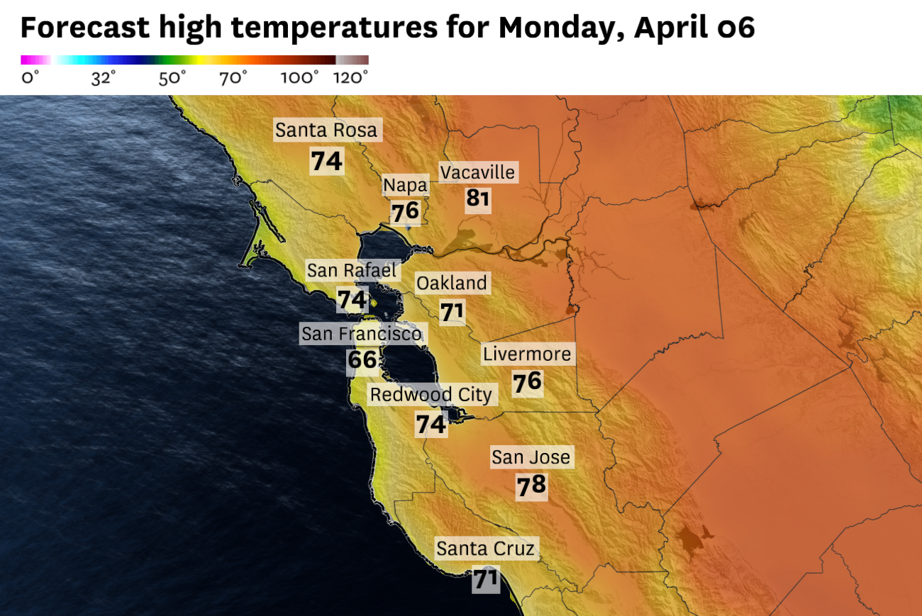
A surge of marine air will keep San Francisco locked in the mid-60s Monday while inland valleys stay warm. The coast-to-inland temperature gap will be as wide as 15 degrees in some spots.
Baron/Lynx
The Bay Area spent the first weekend of April the same way it spent most of March, with temperatures running well above normal. Highs soared into the 70s and 80s in the city and across the inland valleys on Saturday and Sunday, 15 to 20 degrees above normal.
Monday will feel like a completely different season.
A surge of cold marine air began pushing onshore Sunday evening, and by Monday morning it will have transformed the coast. The ridge of high pressure driving the weekend warmth collapsed eastward, reestablishing onshore flow and pushing the marine layer back inland.
Article continues below this ad
After topping out at 80 degrees on Saturday and Sunday, San Francisco will be stuck in the mid-60s on Monday. It will be even cooler along the coast and in the western neighborhoods, where temperatures will spend most of the day in the upper 50s under low clouds, a far cry from the 81 degrees recorded at Ocean Beach over the weekend.
Pockets of drizzle are possible on elevated terrain across the Peninsula and the city, both in the morning and again in the early evening.
San Francisco Chronicle Logo
Make us a Preferred Source to get more of our news when you search.
Add Preferred Source
Away from the water, though, warm temperatures will persist across inland valleys. Concord, Walnut Creek and Livermore all reach the mid-to-upper 70s under partly sunny skies.
Tuesday looks similar to Monday, with the marine layer pushing just a bit further inland and temperatures staying cool along the coast and warm inland.
Article continues below this ad
On Wednesday, the unseasonable warmth will attempt to fight its way back into the Bay Area — and it’s likely to succeed, at least for one day. A brief burst of high pressure brings sunny skies and temperatures back into the 70s for most spots, with the coast staying in the 60s under a less intrusive marine layer.
But by Thursday, the pattern is on the move again. A slow-moving low will meander southward down the California coast Thursday and Friday, attached to a large upper level trough originating from the Gulf of Alaska and bringing a notably cold air mass aloft.
Showers are expected to spread across the Bay Area Thursday afternoon as a slow-moving low pressure system tracks southward down the California coast.
Baron/Lynx
Showers are in the forecast for both days, with the best chance at widespread rain on Friday. Rainfall totals look light to moderate — a quarter to a half inch for most of the Bay Area, with higher amounts possible in the coastal mountains.
The wildcard is thunder. Low-level instability and cold air aloft give Thursday and Friday a 15 to 20 percent chance of thunderstorms, particularly south of the bay. Cut-off lows are notoriously difficult to forecast, and the track of this system will determine how much falls and where.
Article continues below this ad
The forecast details should come into better focus by mid-week.
Monday breakdown
San Francisco: Monday will feel like a reset across the city. Morning clouds are likely to persist for much of the day, especially west of Twin Peaks. Temperatures will hover in the upper 50s in the Sunset and Richmond districts, with a west wind at 10 to 20 mph. Skies will brighten downtown and in places like Bernal Heights and the Mission, with temperatures in the mid-60s. Pockets of drizzle are likely along the immediate coast and hills both in the morning and early evening. Winds strengthen to 15 to 25 mph along the coast and over the hills by afternoon. Mostly cloudy overnight with temperatures in the 50s.
North Bay: A sharp split between coast and interior. Point Reyes and Inverness stay mostly cloudy with highs in the mid-60s. Petaluma and Novato reach the low to mid-70s under partly cloudy skies. Santa Rosa climbs to the mid-70s with skies becoming mostly sunny by afternoon. Napa and the interior valleys top out in the upper 70s, the warmest spots in the region. Patchy fog and clouds develop overnight with lows in the 40s to low 50s.
East Bay: The marine influence fades quickly as you move away from the water. Oakland and Berkeley start partly cloudy before becoming mostly sunny by midday, highs in the mid-60s to low 70s. The warmth holds on stubbornly in the interior valleys. Places like Concord, Walnut Creek and Pleasanton climb into the mid-to-upper 70s, with Livermore and Antioch near 80 degrees under sunny skies. Overnight lows drop to the upper 40s inland, around 50 along the shoreline with partly cloudy skies.
Article continues below this ad
Pacific Coast: The most noticeable change Monday will be along the immediate coast. Pacifica and Half Moon Bay should stay mostly cloudy all day with highs in the upper 50s to low 60s and a west wind at 10 to 20 mph. Pockets of drizzle are possible in the morning and again in the afternoon, especially around Daly City. Staying mostly cloudy overnight with lows in the mid-40s to low 50s,
Peninsula: The Peninsula will have a clear gradient on Monday. Clouds and cool temperatures will persist in South San Francisco and SFO, with highs in the low to mid-60s and an afternoon west wind at 15 to 25 mph. Further south, skies will clear more quickly as places like Redwood City and Menlo Park climb into the low to mid-70s, with just a light west wind. Clouds will likely move back in overnight and temperatures will be in the low 50s.
South Bay: The South Bay should be the brightest spot in the region on Monday. Any morning clouds clear quickly and under mostly sunny skies, San Jose, Los Gatos, Morgan Hill and Gilroy should all reach the mid- to upper 70s, with just a light northwest wind. Overnight skies stay mostly clear before patchy fog develops late, with lows dropping to the mid- to upper 40s.