
Northern California’s weather is about to take a dramatic turn.
Warm sunshine will prevail in most places Wednesday, but scattered thunderstorms are predicted Thursday and Friday as a cutoff low-pressure system slowly nudges closer. The Sacramento Valley has the highest chances of thunderstorms both days.
Those scattered thunderstorms will be a harbinger of a more potent system that’s expected to bring widespread rain and mountain snow over the weekend. It may not be a true storm, but it will probably be Northern California’s most unsettled stretch of weather since mid-February, a big change from previous forecasts that indicated April might continue March’s abnormally warm and dry pattern.
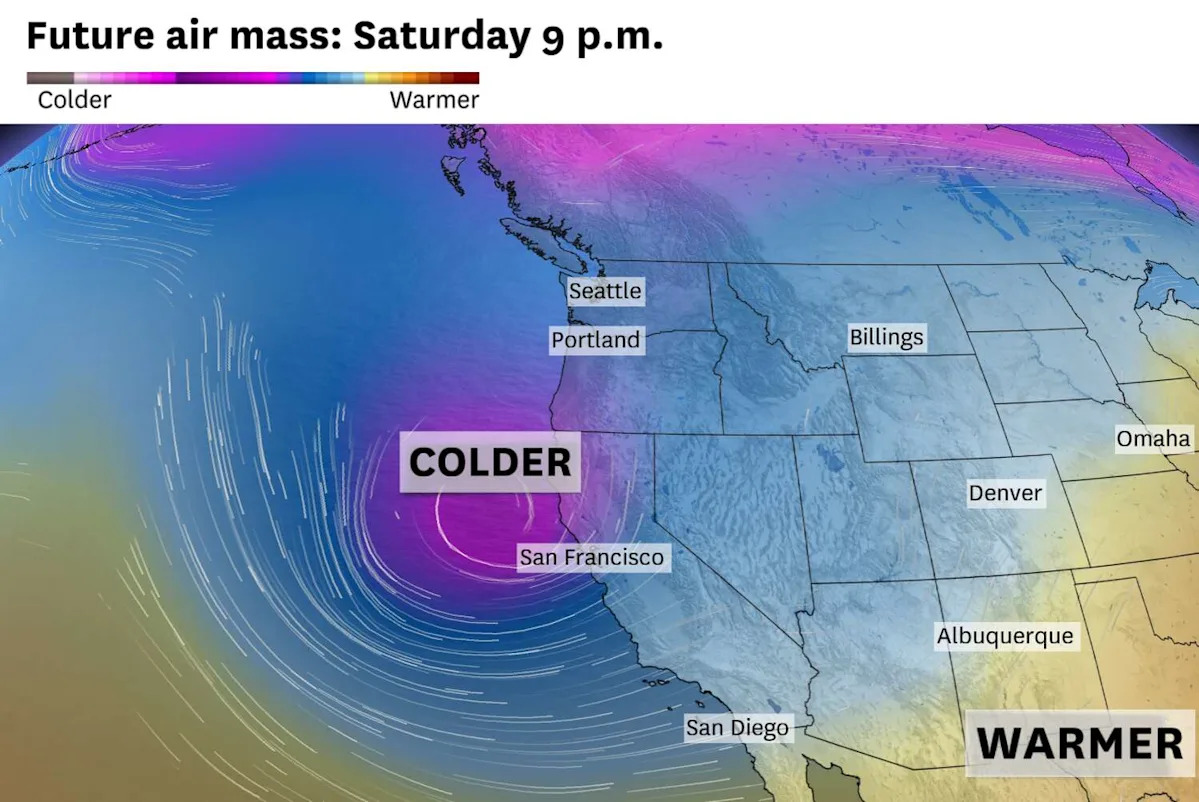
An “energetic” system from the Gulf of Alaska is forecast to swing across Northern California this weekend and tap into a chilly air mass, the National Weather Service said in an online forecast. The system will “drive a strong frontal system across the Western U.S. that will bring increasing precipitation chances, rain and mountain snow this weekend,” the weather service said.
With cold air in play, precipitation will probably fall as snow in the Lake Tahoe area, especially by Sunday when the freezing line may be as low as 5,000 feet. Tahoe ski resorts could pick up a foot of snow or more by Sunday night.
It probably won’t be a true storm in the Bay Area, though it may feel that way in contrast to the recent weeks of unusual early spring warmth.
A cold front is expected to push across the Bay Area on Saturday, likely triggering breezy winds and at least a few hours of steady rain. Scattered showers are forecast to stick around Sunday, as the cold air overhead will be a sharp contrast to the above-normal water temperatures along the Pacific coast. This temperature gradient will provide the energy for higher thunderstorm chances in coastal areas, including San Francisco.
The erratic nature of showers makes it difficult to forecast exact precipitation totals, but generally the wettest areas like the North Bay should receive more than an inch of rain by Sunday night. Half of that amount is predicted in typically drier areas like Livermore and San Jose.
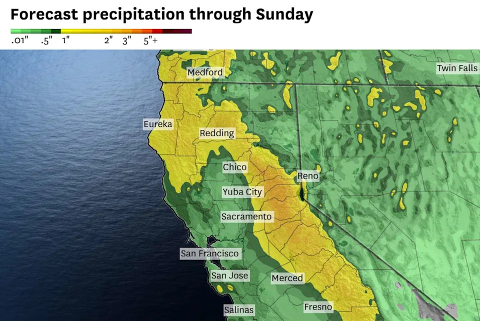
The National Weather Service forecasts widespread precipitation across Northern California through Sunday, with rainfall totals up to an inch in the Bay Area. (Baron/Lynx)
Temperatures may not surpass 60 degrees in many Bay Area cities Sunday, with nighttime temperatures potentially falling into the 30s in the valleys.
There’s a “high amount of uncertainty” in next week’s forecast, the weather service said. There are equal chances of another rainmaker or a return to warm and dry weather.
Wednesday breakdown
San Francisco: A cloud-filled marine layer is expected to blanket the city for a cool, gray morning. Sunshine will prevail by midmorning, with highs in the low 60s west of Twin Peaks, the Marina and Cole Valley, and the mid- to upper 60s in the Mission District, Noe Valley, Portola, Bayview and downtown. Westerly winds are expected to gust up to 15 mph in the afternoon. Overnight lows will be in the mid-50s with increasing clouds.
North Bay: Patchy fog should clear by midmorning for mostly sunny skies the rest of the day. Highs will be in the 60s at the coast, upper 60s to low 70s in Sausalito, Mill Valley and Petaluma, the mid- to upper 70s in Santa Rosa, Vallejo, Napa Valley and Sonoma Valley, and the upper 70s to low 80s in Fairfield and Vacaville. A rogue rain shower may pop up near Mount St. Helena in the afternoon. Clouds will increase overnight with lows in the upper 40s to low 50s.
East Bay: Low stratus clouds should overspread Berkeley and Oakland at sunrise before retreating back across the bay by midmorning. Skies will be mostly sunny in the afternoon, aside from some bubbly cumulus over the Diablo Range. Highs will be in the low to mid-70s west of the Caldecott Tunnel and the mid- to upper 70s to the east. Antioch and Brentwood may reach the low 80s. Lows will be in the low to mid-50s with increasing clouds.
Pacific Coast and Peninsula: “The chances are very good that a cloud filled marine layer makes it to the coast … but SFO itself may stay in a clear pocket,” the National Weather Service said. Daly City, Pacifica and Half Moon Bay should see at least a few hours of midday sunshine before clouds return. Highs will be in the low 60s there. More sunshine is expected along the Highway 101 corridor, where temperatures should climb to the upper 60s to low 70s. Overnight lows will be in the low to mid-50s with increasing clouds.
South Bay and Santa Cruz: A warm-up is expected under mainly clear skies. Highs will reach the low to mid-70s near the bay shoreline and the upper 70s in San Jose, Cupertino, Morgan Hill, Gilroy and the Santa Cruz Mountains. A few clouds may bubble up over the Diablo Range in the afternoon. Santa Cruz should start cloudy before sunshine emerges. Highs there will be in the low 70s. Clouds will increase overnight with lows in the low to mid-50s.
This article originally published at Northern California weather turns unsettled with rain, snow, thunderstorms.