
SAN DIEGO (FOX 5/KUSI) — San Diego County is getting some much needed rainfall this weekend with more scattered showers expected Sunday afternoon into Monday.
During last week’s data drop from the U.S. Drought Monitor, parts of San Diego County were listed as abnormally dry, a step before moderate drought status. This follows a trend with the rest of the state as drought has officially returned to California, with less snowpack, warmer than normal temperatures, early snowmelt and dryness over the past 60 days all contributing.
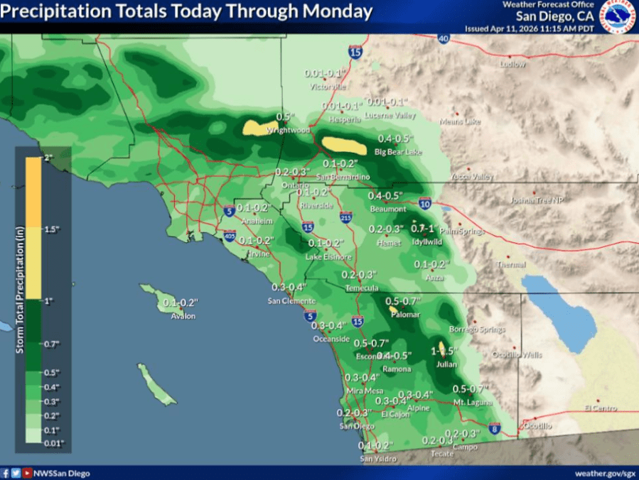
Rainfall totals this weekend in San Diego County are forecast to stay around a half inch as scattered showers will bring a bit more moisture to some of those dry areas, the National Weather Service (NWS) reports.

This graphic from the U.S. Drought Monitor shows 7.6% of California is currently experiencing drought conditions and 48.7% Abnormally Dry conditions. (U.S. Drought Monitor)
The rain will also come with a bit of a cool down, with temperatures about 15 to 20 degrees lower than usual for this time of year, according to NWS. Highs temperatures along the coast and in inland valleys will stay in the mid-60s on Sunday.

High temperatures for today will be notably, at around 5 to 15 degrees below the seasonal average for this time of year. At the coast and inland valleys, highs will generally be in the low to mid 60s, with 40s to low 50s for the mountains, upper 50s to low 60s for the high deserts, and 70s for the low deserts (NWS)
Odds of a ‘Super El Nino’ growing, model shows. What that could mean
Scattered rain showers and a 15-20% chance of thunderstorms are forecast to linger over San Diego County through Monday.

Moderate rain develops early Sunday into Sunday afternoon, moving from north to south. Light rain showers linger into Monday for San Diego County. Light snow in the mountains above 6500 feet. (NWS)

A second round of scattered showers are expected to begin tonight. More moderate steady rainfall is expected to sweep through the region Sunday morning associated with the main cold front – from northwest to southeast – reaching San Diego around noon Sunday (timing is subject to change). A slight (15-20%) chance for thunderstorms expected Sunday with the front (NWS)
The high winds will peak Sunday afternoon, with gusts up to 45 to 50 mph in areas of higher terrain and through mountain passes and canyons.
Caltrans issued a high wind advisory Sunday morning for east and west I-8 from In-Ko-Pah to Ocotillo in Imperial Valley.

Winds will increase and become rather gusty by later this afternoon, especially across the higher terrain and through mountain passes and canyons, where there could occasionally be gusts of 45 to 50 mph for a few locations (NWS)
Some mountain areas will even get some snowfall through Monday with this storm.

There is potential for light mountain snow for today. Snow levels will hover around 6,500-7,000 ft through this morning before falling to 6,000 ft by later in the day – when there is the best chance of accumulating snow for mountain communities. There is ~ 60% chance of snowfall greater than one inch in total for today at Big Bear Lake: ~ 40% chance for Wrightwood (NWS)
More weather: ➡️ Forecast | ⚠️ Alerts | 🗺️ Live Radar | 📧Newsletter
Full forecast at fox5sandiego.com/weather
Copyright 2026 Nexstar Media, Inc. All rights reserved. This material may not be published, broadcast, rewritten, or redistributed.
For the latest news, weather, sports, and streaming video, head to FOX 5 San Diego & KUSI News.