
Rain, mountain snow and locally heavy thunderstorms will spread across California into midweek, bringing slick travel, gusty winds and a boost to seasonal rainfall totals in some areas.
Published Apr 18, 2026 10:46 AM CDT
|
Updated Apr 19, 2026 4:57 AM CDT
A compilation of powerful hailstorms shows severe weather battering communities nationwide, with intense downpours and large hail damaging vehicles, buildings and landscapes.
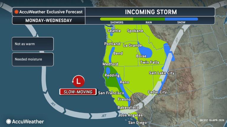
A new storm will push into California from Monday to Wednesday, bringing rain, mountain snow and locally gusty thunderstorms. The storm will create slick travel conditions and ponding in poorly drained areas across northern and central parts of the state.
Even though the storm will pale in comparison to some of the storms from early spring and winter, storms such as this are valuable, as the historical average rainfall and mountain snow tend to dwindle from April to May, with the dry season looming.
The storm is on track to bring a general 0.50 of an inch to 1.50 inches of rain to Northern and Central California.
Localized totals of 1.50 to 3.00 inches are possible along the west-facing slopes of the Coast Ranges and the lower west- and southwest-facing slopes of the Siskiyous and the northern and central Sierra Nevada.
San Francisco is already well above the historical average rainfall for April, with 2.19 inches so far, compared to 1.36 inches. The storm from April 10-12 brought the bulk of the rain. Since the start of the rainy season, San Francisco is very close to its 30-year average rainfall of 18.51 inches.
The storm may bring little more than a couple of showers or a thundershower to Los Angeles. However, the city is well above average since Oct. 1, with 18.87 inches compared to the normal 13.50 inches.
Fresno, California, could pick up about a half inch of rain, which may bring monthly totals close to average, given the midmonth storm. Since Oct. 1, Fresno has received 9.52 inches, compared to the 30-year average of just under 10 inches.
Have the app? Unlock AccuWeather Alerts™ with Premium+
The storm will also spread needed rainfall across much of Washington and Oregon, as well as central and northern Nevada and parts of Utah and Idaho.
The storm’s proximity, combined with strong April sunshine, will create a favorable environment for thunderstorm development in California.
As clouds tower high into the colder, windier upper atmosphere, small to medium-sized hail can develop and fall to the ground. The hail and downdrafts from the storms can create locally damaging wind gusts at ground level.
Some of the heaviest thunderstorms may trigger highly localized flash flooding despite prior dry conditions. Brief but intense downpours can also reduce visibility for motorists.
Ahead of downpours, gusty winds may kick up dust. Lightning strikes in areas with little or no rainfall could also spark small wildfires.
In the Sierra Nevada, showers may not fully overspread the range until Monday night or Tuesday. Initially, snow levels will be well above the passes on Tuesday.
By Tuesday night into Wednesday, snow levels will drop to pass level, bringing a few slushy inches and potentially slowing travel over Donner Pass, California.
Heavy snow in the Sierra earlier this season highlights how this system compares:
A stop sign was half buried in snow in a Donner Lake neighborhood on Monday, March 4, 2024, in Truckee, California. A powerful blizzard that closed highways and ski resorts moved through the Sierra Nevada in early March. (AP Photo/Andy Barron)
Like the rainfall, snowfall from this system will be minor compared to winter storms. However, any late-season snow will contribute to runoff and help replenish streams and reservoirs heading into summer.
More stories of interest:
Want next-level safety, ad-free? Unlock advanced, hyperlocal severe weather alerts when you subscribe to Premium+ on the AccuWeather app. AccuWeather Alerts™ are prompted by our expert meteorologists who monitor and analyze dangerous weather risks 24/7 to keep you and your family safer.