
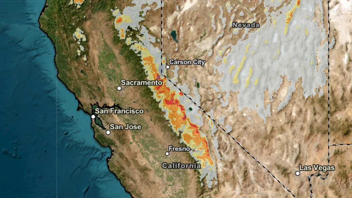
A Pacific weather system associated with an upper-level low is forecast to bring heavy snow and strong winds to the Sierra Nevada, California, from late April 20 through April 22, with the most significant impacts expected on April 21.
The National Weather Service (NWS) has issued multiple Winter Storm Watches covering several Sierra Nevada zones, including Yosemite National Park outside of the valley, Kings Canyon and Sequoia National Parks, Mono County, and the greater Lake Tahoe region. The alerts are valid from late night on April 20 through the afternoon of April 22 (local time).
Areas above 2 100 m (7 000 feet) are expected to receive approximately 8-13 cm (3-5 inches) of snow, while elevations above 2 400-2 700 m (8 000-9 000 feet) could see 15-30 cm (6-12 inches). The highest peaks of the Sierra Nevada may receive up to 30-60 cm (12-24 inches), with locally higher totals possible under heavier snow bands.
 Image credit: NWS
Lower elevations, including communities near Lake Tahoe, may see lighter accumulations of 2-10 cm (1-4 inches), particularly along western shores. Snow levels are forecast to start at approximately 1 800-2 100 m (6 000-7 000 feet) on the night of April 20, lowering to around 1 400-1 700 m (4 500-5 500 feet) by April 22, allowing snow to impact a broader range of elevations over time.
Strong winds are expected to accompany the system, with gusts of 65-80 km/h (40-50 mph) at lower elevations and significantly stronger winds along ridgelines. The Sierra crest could experience gusts up to 120-145 km/h (75-90 mph), producing blowing snow and sharply reduced visibility in exposed terrain.
Travel impacts are expected across major mountain corridors, including Interstate 80 over Donner Pass, U.S. Highway 50, and U.S. Highway 395.
The NWS warns that roads, especially bridges and overpasses, are likely to become slick and hazardous, with visibility potentially dropping below 0.4 km (0.25 miles) due to falling and blowing snow. Travel could become very difficult or impossible, particularly during the morning of April 21 and the evening commute periods.
The Weather Prediction Center (WPC) reported that the incoming Pacific system will bring increasing precipitation chances to the West Coast, with heavy snow concentrated over the Sierra Nevada as the upper-level low slowly crosses the region.
The system will also introduce cooler conditions, with daytime highs dropping into the 10-20°C (50-60°F) range across California by April 21.
Additional hazards include the potential for tree damage and power outages due to the combination of heavy snow and strong winds. In higher elevations, isolated lightning is also possible along the Sierra crest during April 21 and 22 as instability increases.
Residents and travelers have been advised to avoid travel if possible during the storm period and to monitor the latest forecasts for updates as conditions evolve. Persons traveling through affected areas are urged to prepare for rapidly changing weather, reduced visibility, and winter driving conditions.
References:
1 Short Range Forecast Discussion – NWS/WPC – April 20, 2026
2 Winter Storm Watch – NWS/WPC – April 20, 2026