
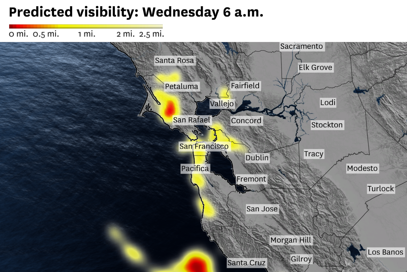
Low clouds and fog may obscure visibility in San Francisco, Oakland and coastal areas of Marin and San Mateo counties on Wednesday morning. Rounds of morning fog are expected the next few days as a summerlike atmospheric pressure pattern takes shape.
Baron/Lynx
After rounds of rain and thunderstorms dominated much of April, Bay Area weather is taking a gradual shift toward more summerlike conditions for the final two days of the month.
Conditions will be much drier and warmer as a high-pressure system nudges over the region. Abundant sunshine is expected to send temperatures soaring into the 70s across the Bay Area on Wednesday, but one area is an exception: the coast.
Late April and May is the time of year when the marine layer tends to rebuild, often bringing fog to San Francisco and beach towns along much of the California coast. The marine layer is a shallow region of ocean-chilled air that is capped by warmer air above. It’s part of the reason Stinson Beach can be 60 degrees in the summer at the same time the summit of Mount Tamalpais approaches 90 degrees.
Article continues below this ad
The marine layer can be dry, but most of the time winds off the Pacific add moisture to the lower atmosphere and obscure the covered region under a thick fog. Sunrise tends to be the foggiest time of day in San Francisco when winds are calmest, which prevents dry, warm inland air from chewing at the marine layer from the sides and above.
San Francisco is forecast to remain in the 60s Wednesday while the other major Bay Area cities reach the 70s. The marine layer will begin to reestablish itself, a pattern that is most pronounced in summer and keeps the coast cooler than inland areas.
Baron/Lynx
Wednesday morning is expected to bring another round of fog in San Francisco, a sign of the shifting seasons. Skies will probably clear by 10 a.m., but the cool ocean air will persist, keeping the city in the 60s, rather than 70s that are forecast to pop up just across the bay.
San Francisco Chronicle Logo
Make us a Preferred Source to get more of our news when you search.
Add Preferred Source
Northwest winds down the California coast push this cool ocean air toward the city, funneling through the Golden Gate and across San Francisco Bay. Those northwest winds tend to strengthen in May as the Pacific High — a large, semipermanent area of high pressure — reestablishes itself between the Gulf of Alaska and the West Coast.
Article continues below this ad
Northwest wind gusts up to 25 mph are expected in San Francisco on Wednesday afternoon.
Baron/Lynx
Winds should turn slightly more northerly Thursday morning, a drier direction that may limit fog development in parts of the North Bay and East Bay, but not completely in San Francisco and the Peninsula. That shift will also push temperatures toward 80 degrees in some inland valleys. Friday is forecast to mirror Thursday for the most part.
Occasional low-pressure systems in May — like the one expected this weekend — can interrupt the progression of the Pacific High and associated coastal marine layer, but for the most part mid-spring is a transition period from the wet season to San Francisco’s staple summer fog.
Wednesday breakdown
San Francisco: A summerlike temperature distribution is expected across the city, with morning fog and highs in the low 60s in the Richmond and Sunset districts and the mid- to upper 60s east of Twin Peaks under mainly clear skies. West winds will gust 15 to 25 mph in the afternoon. Overnight lows will be in the mid-50s.
Article continues below this ad
North Bay: Areas of fog at sunrise will give way to clear skies by midmorning. Highs should reach the mid- to upper 70s in most places, except in Vacaville, where the mercury is expected to hit 80, and coastal areas where a cool breeze keeps temperatures in the 60s. Winds will gust 10 to 20 mph in the late afternoon, strongest near the delta. Overnight lows will be in the mid- to upper 40s.
East Bay: Following patchy morning fog, the clearest sky since mid-month is expected in the afternoon as a high-pressure system builds in. Temperatures will increase as a result, with highs in the upper 60s to low 70s in Richmond, Berkeley, Oakland, Alameda, Hayward and Fremont and the mid- to upper 70s in Dublin, Pleasanton, San Ramon, Walnut Creek and Antioch. Afternoon gusts of 10 to 25 mph are expected, strongest in Livermore Valley. Overnight lows will be in the upper 40s to low 50s with areas of low clouds and fog.
Pacific Coast and Peninsula: A warmup will push high temperatures into the 70s for most of San Mateo County, following a cool, foggy morning. Skies should clear by 10 a.m. for a mostly sunny afternoon. Daly City, Pacifica and Half Moon Bay should reach the low to mid-60s before an afternoon breeze gusting up to 20 mph knocks temperatures down. Highs in the low 70s are expected along the Highway 101 corridor, with gusts up to 25 mph through the San Bruno Gap in the late afternoon. Lows will be in the mid-50s with areas of fog.
South Bay and Santa Cruz: Patchy fog in the early morning will be followed by abundant sunshine the rest of the day. Highs will be in the 70s everywhere, including Santa Cruz. Gilroy, Morgan Hill and South San Jose are expected to be the warmest spots, in the upper 70s, with low to mid-70s elsewhere. Winds will become breezy in the afternoon through the evening. Overnight lows will be in the mid-40s to low 50s, with patchy fog by daybreak Thursday.
Article continues below this ad