
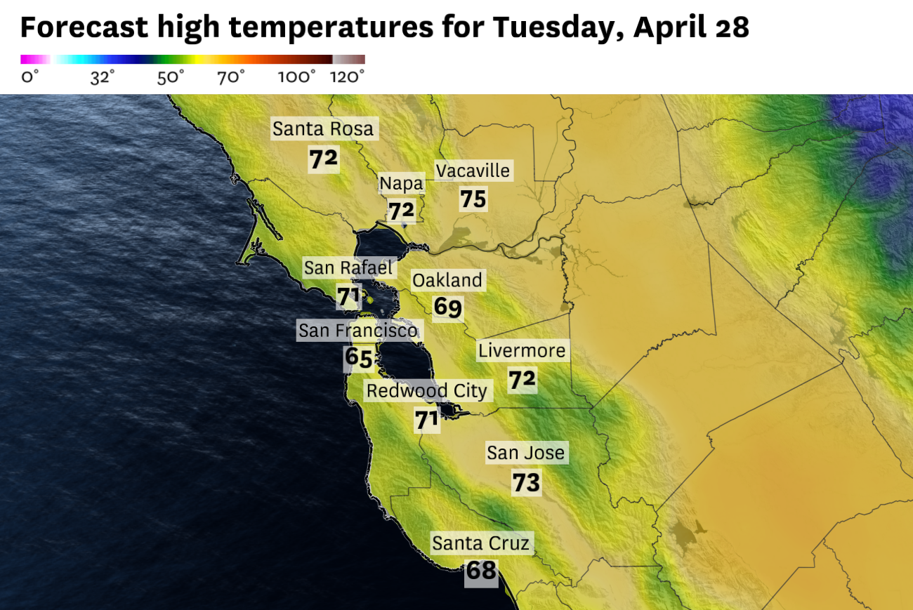
Morning clouds will linger around parts of the Bay Area on Tuesday before sunshine becomes more widespread by afternoon and temperatures warm into the 60s and low 70s.
Baron/Lynx
Latest forecast: Bay Area warms into the 70s — but S.F. stays cool as fog returns
The Bay Area should start to warm up Tuesday, but the change will be uneven. Inland areas should see more afternoon sunshine and highs back in the 70s, while San Francisco, Oakland and the coast stay cooler under morning clouds and a persistent onshore breeze.
The change will be most noticeable away from the water. After several cool, cloudy days, inland parts of the North Bay, East Bay and South Bay should see enough afternoon sunshine for temperatures to climb back toward typical late-April levels.
Article continues below this ad
The coast and bay shoreline will be slower to warm. Low clouds are likely Tuesday morning from the Pacific coast into San Francisco, the Peninsula and parts of the East Bay. Some clouds may also spill inland early in the day before breaking apart by afternoon.
The reason is the marine layer, a shallow blanket of cool, damp ocean air that often separates the Bay Area into different weather zones. It will not be strong enough to keep the whole region gray all day, but it should be enough to hold San Francisco, Oakland and the immediate coast mostly in the 60s.
San Francisco Chronicle Logo
Make us a Preferred Source to get more of our news when you search.
Add Preferred Source
Inland highs should reach the lower 70s Tuesday in Santa Rosa, Napa, Concord, Walnut Creek, Livermore and San Jose. Redwood City, Palo Alto and Fremont should land in the upper 60s to near 70. San Francisco will likely top out in the lower 60s, with the west side and nearby coast closer to the upper 50s.
Wednesday and Thursday look warmer, especially inland, as winds change to a north/northeasterly direction. Highs could reach the mid- to upper 70s in the warmest inland valleys by Thursday.
Article continues below this ad
Tuesday breakdown
San Francisco: Morning clouds will linger across much of San Francisco on Tuesday, especially on the west side and near the coast. Some brighter breaks should develop by afternoon, but west winds off the ocean will keep temperatures cool. Highs will reach the lower 60s downtown and near the bay, while the Sunset and Richmond districts stay closer to the upper 50s. West winds will increase to 10 to 20 mph during the afternoon, strongest near Ocean Beach and Twin Peaks. Tuesday night will be mostly clear, with lows in the lower 50s.
North Bay: Low clouds and patchy fog are possible early Tuesday, especially near the coast and around the bay. Afternoon clearing should be more noticeable inland, with Santa Rosa and Napa climbing into the lower 70s. Petaluma, San Rafael and Novato should reach the mid- to upper 60s. Winds will be light in the morning, then turn west to northwest at 5 to 15 mph during the afternoon. It will be mostly clear on Tuesday night with lows in the mid- to upper 40s.
East Bay: Clouds will be slowest to clear near the bay shoreline Tuesday morning, but sunshine will eventually develop. Farther inland, the sun will come out earlier, helping Walnut Creek, Concord, Pleasanton and Livermore climb into the lower 70s. Oakland, Berkeley and Alameda should be in the mid-60s. Winds will turn west to northwest at 10 to 20 mph during the afternoon, strongest through the gaps and near the bay shoreline. It will be partly cloudy on Tuesday night with lows in the upper 40s to lower 50s.
Pacific Coast: The immediate coast will be the slowest part of the region to warm Tuesday. Morning clouds may linger for much of the day in places such as Pacifica, Half Moon Bay, Point Reyes and the Sonoma Coast. Highs will mostly stay in the upper 50s to lower 60s, with a persistent onshore breeze adding to the cool feel. Northwest winds will increase to 10 to 20 mph during the afternoon. Tuesday night will stay mostly cloudy, with lows in the upper 40s to lower 50s.
Article continues below this ad
Peninsula: Low clouds are likely on Tuesday morning along the Peninsula. Redwood City, Palo Alto and Menlo Park should see more sunshine by afternoon, allowing highs to reach the upper 60s to near 70. Winds will turn west to northwest at 10 to 20 mph by afternoon, strongest along the coast and through the San Bruno Gap. It will be mostly clear and breezy on Tuesday night lows with lows in the upper 40s to lower 50s.
South Bay: Morning clouds may start the day, but sunshine should become more widespread by afternoon. San Jose should reach the lower 70s, with similar temperatures in Santa Clara, and down through Los Gatos. Afternoon northwest winds will increase to 10 to 15 mph, with a few higher gusts near the foothills and through the valley. It will be mostly clear on Tuesday night, with lows mostly in the upper 40s.