
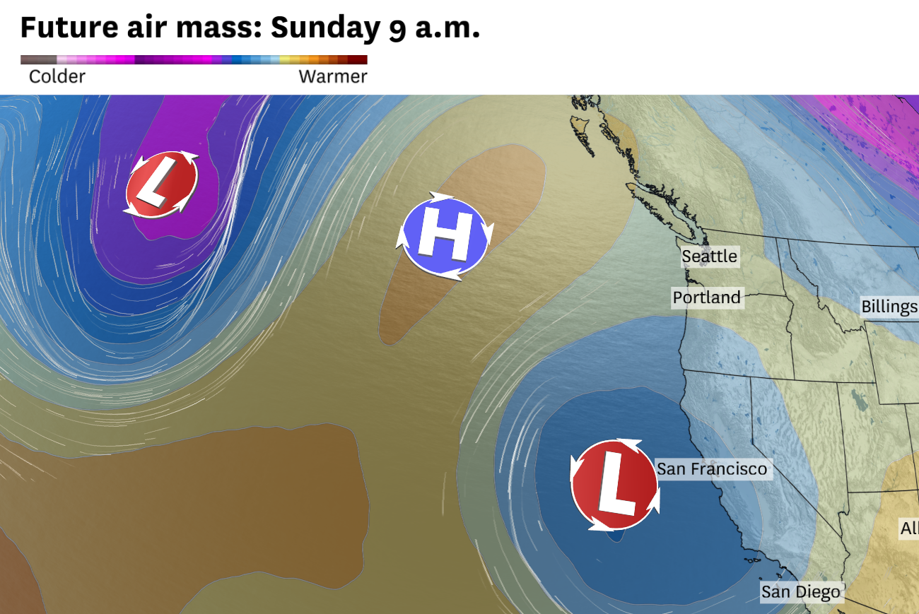
Sunday morning’s atmospheric setup shows a near-textbook omega block: a strong high-pressure system anchored over the Gulf of Alaska between two low-pressure systems. The eastern low, parked just off the California coast, will deliver the Bay Area’s drizzle and keep the cool, cloudy pattern locked in place.
Baron/Lynx
The first weekend of May is trending cooler than earlier forecasts suggested, and the reason is taking shape thousands of feet above the Pacific.
A slow-moving low-pressure system will drift toward California this weekend, while high pressure strengthens farther north over British Columbia and the Gulf of Alaska. The setup has signs of an omega block, a pattern that can slow the atmosphere’s usual west-to-east movement and keep weather systems stuck in place.
Article continues below this ad
For the Bay Area, that means Friday may be the last mild inland day before clouds and cooler air take over.
The bigger shift arrives Saturday, as the low pressure system edges closer to California. Colder air several miles above the surface, thicker cloud cover and a deeper marine layer should knock temperatures down across the region. Inland valleys that would normally reach the 70s in early May should hold in the 60s. San Francisco could stay stuck in cloud cover all day and struggle to break 60 degrees.
By Sunday, the pattern becomes more stubborn and a bit more uncertain. High pressure to the north will help slow the offshore low, keeping the Bay Area cool, mostly cloudy and at risk for drizzle, especially near the coast and around the bay.
San Francisco Chronicle Logo
Make us a Preferred Source to get more of our news when you search.
Add Preferred Source
Here’s a more detailed breakdown.
Article continues below this ad
Friday: A sharp temperature divide
Friday brings the most pronounced temperature divide of the weekend. By morning, northwest winds will be blowing steadily enough to reinforce the marine layer and keep clouds locked in near the coast and bay shore.
Inland valleys, farther removed from the marine layer, should get enough afternoon sunshine to reach into the 70s. But just how far the marine layer pushes inland remains uncertain.
Places like Concord, Dublin and Livermore in the interior East Bay, as well as San Jose and Santa Clara in the South Bay, have the best chance of reaching 70 degrees. Those locations should see enough afternoon sunshine to support the warmup.
Friday afternoon temperatures show the weekend’s sharpest split. Inland valleys reach the upper 70s while a strengthening marine layer keeps San Francisco near 60 and Half Moon Bay in the mid 50s.
Baron/Lynx
In San Francisco and closer to the coast, temperatures are likely to be much cooler. Clouds and onshore winds will be in place Friday morning across San Francisco, the Peninsula and bayside parts of the East Bay.
Article continues below this ad
The cloud cover is unlikely to break in San Francisco, while Oakland and Richmond have a decent shot at partial sunshine in the afternoon. Even there, the sun may not help temperatures much.
San Francisco may struggle to break 60 degrees, while Oakland, Berkeley and much of the Peninsula will top out in the low to mid-60s.
Saturday and Sunday: The pattern gets stuck
Saturday is when the cooler pattern takes over more broadly and when things become “stuck” in the atmosphere thanks to the developing omega block.
An omega block forms when a strong dome of high pressure builds between two areas of low pressure. On a weather map, the three features together trace the shape of the Greek letter omega.
Article continues below this ad
The defining feature of a block is that it stops the normal eastward progression of weather systems. Storm tracks divert around it and the pattern stays put, sometimes for several days, until something disrupts it.
This weekend’s version is a near textbook example.
A sprawling high pressure system will become anchored over British Columbia, driving record high temperatures in the Pacific Northwest. Meanwhile, the offshore low pressure system will move closer to the California coast, spreading more cloud cover inland and pulling in colder air several thousand feet above the surface. (Another low-pressure system lurks in the northern Pacific, the other side of the sandwich for the high-pressure system.)
Both factors will work towards strengthening the marine layer and locking in cool and cloudy conditions.
Article continues below this ad
Inland areas figure to feel the biggest change.
Places that were in the 70s on Friday will likely stay in the 60s though the weekend. It will be even cooler in San Francisco, where there is a decent chance that parts of the city won’t rise above 60 degrees on both Saturday and Sunday. Drizzle is also possible, especially by Sunday near the coast, around San Francisco and along the Peninsula.