
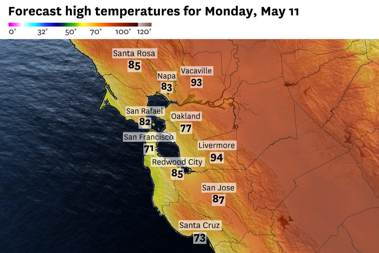
Monday’s temperatures will be toasty around the Bay Area.
Baron/Lynx
It turns out the big winner of Mother’s Day weekend was the marine layer.
An expected weekend warmup never really materialized, even across the interior and away from the water. Forecasts called for highs to climb steadily, peaking in the upper 80s and even lower 90s by Sunday across much of the region. Instead, most of the Bay Area stalled in the 60s and 70s all three days.
The setup was straightforward Friday and Saturday: persistent onshore flow kept the marine layer locked in across San Francisco, Oakland and the shoreline, largely as expected. But the twist came overnight Friday into Saturday, when the surface pressure gradient between the coast and the interior collapsed.
Article continues below this ad
With less wind pushing marine air inland or scouring it out, the marine layer didn’t clear. It settled in, deepened and dug in. That’s why Sunday came in cooler than Saturday in many spots, even though it had been expected to be the warmest day of the weekend.
Monday is still expected to be the warmest day of the week, but the forecast comes with a high degree of volatility. Interior locations should warm into the mid-80s to lower 90s, while cooler conditions hold near the coast and bayshore as the marine layer and onshore flow persist.
San Francisco Chronicle Logo
Make us a Preferred Source to get more of our news when you search.
Add Preferred Source
The key question is how quickly the marine layer retreats. Onshore flow should redevelop Monday, but it won’t be as strong as it was Friday or Saturday. Even a moderate onshore breeze would keep San Francisco, the Pacific Coast and parts of the bayside East Bay cool. Farther inland, enough sunshine should allow temperatures to climb into the mid- to upper 80s, with a few lower 90s possible.
That’s if the stubborn marine layer retreats enough.
Article continues below this ad
A low-pressure system will linger near the Bay Area midweek, bringing cooler temperatures and clouds.
Baron/Lynx
After Monday, the forecast looks less like an extended warm spell and more like another unsettled spring pattern. A weak low-pressure system will slide down the California coast by midweek, keeping clouds and cooler temperatures in the forecast. Precipitation is unlikely, though coastal drizzle or a stray shower can’t be completely ruled out.
The summerlike heat has been postponed for now.
Monday breakdown
San Francisco: Low clouds and fog will return overnight and probably linger into Monday morning, especially in the Outer Sunset, Richmond, Twin Peaks and Presidio. Some thinning is possible late in the morning, with better clearing east of Twin Peaks, but the marine layer should stay close enough to keep temperatures in check. Highs will range from the low 60s near Ocean Beach to the upper 60s downtown, SoMa and the Mission. A few eastern neighborhoods should eclipse 70 degrees with enough sunshine. West winds will increase to 10 to 20 mph in the afternoon, and low clouds will return Monday night. Lows will be in the low to mid-50s.
Article continues below this ad
North Bay: Morning clouds may push into Marin, the Petaluma Gap and southern Sonoma County, but clearing should happen faster inland than it did over the weekend. Santa Rosa, Napa and Sonoma should climb into the mid-80s. Marin will stay cooler, with highs in the 60s near Sausalito and Mill Valley and 70s to low 80s around San Rafael and Novato. Overnight lows will range from the upper 40s to mid-50s, with some low clouds returning near the bay and coast.
East Bay: The East Bay will see one of the sharper temperature splits Monday. Oakland, Berkeley, Alameda and Richmond will start with low clouds and stay moderated by the bay, but highs should still top out in the mid-70s. Inland areas should clear more quickly. Walnut Creek, Pleasanton and Dublin should reach the mid-80s, while Concord, Livermore and Antioch should climb into the lower 90s. Overnight lows will be in the low to mid-50s.
Pacific Coast and Peninsula: Fog and low clouds will hang on longest along the coast, keeping Daly City, Pacifica and Half Moon Bay in the low to mid-60s. The inland Peninsula should warm more, but the forecast depends on how quickly clouds retreat. South San Francisco and San Mateo should reach the mid-70s, while Redwood City could climb into the mid-80s. Low clouds return Monday night, especially near the coast and along the bayshore. Overnight lows will be in the upper 40s to mid-50s.
South Bay and Santa Cruz: Morning clouds may reach parts of the South Bay, but enough clearing should develop for a warmer afternoon. San Jose, Santa Clara and Cupertino should reach the upper 80s, while Los Gatos, Morgan Hill and Gilroy should climb into the 90s. Santa Cruz will stay cooler under a stronger marine influence, with highs in the low 70s. Low clouds return near the coast Monday night, with lows in the upper 40s to mid-50s.
Article continues below this ad