
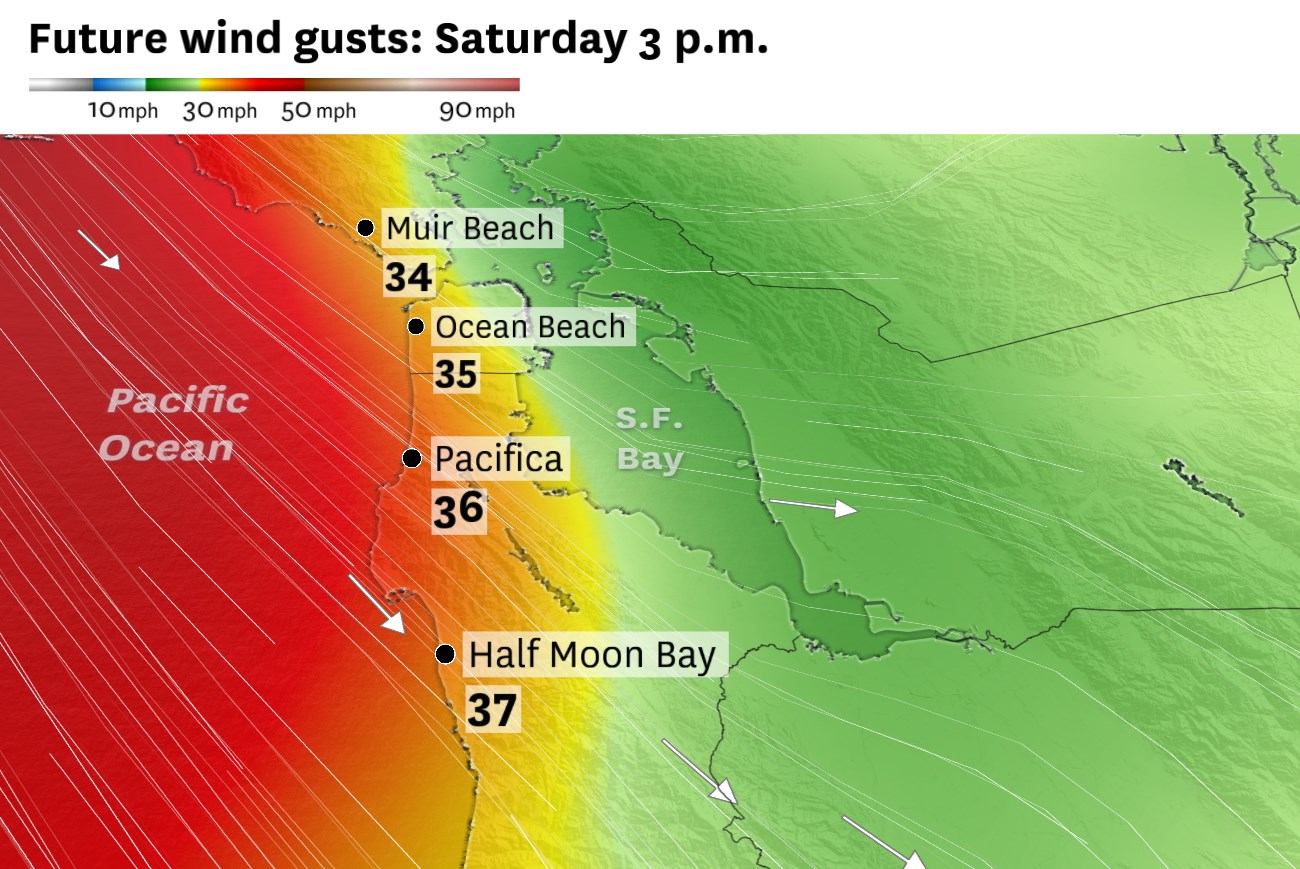
Blustery weather is expected the next few days along the Pacific coast. The strongest winds are expected Saturday with frequent gusts of 35 to 45 mph.
Baron/Lynx
The windiest weather in months is anticipated to whip the Bay Area and other portions of Northern California for at least the next four days.
San Francisco was already buffeted by breezy conditions earlier in the week, but even stronger winds are expected Friday through Sunday. Rough seas whipped up by the winds will pose danger to surfers and mariners, and critical fire weather conditions are expected in the Central Valley. Turbulence could also impact flights at San Francisco International Airport.
Northwest winds often flow down the California coast from mid spring through summer as the North Pacific High — a large area of semipermanent high pressure — expands over the ocean. Winds are drawn inland by an area of low pressure in the Central Valley that forms each afternoon due to warm air rising from the surface, leaving room for cool, dense ocean-chilled air to fill the void.
Article continues below this ad
The North Pacific High is expected to get nudged further east than normal by Friday as an unseasonably strong jet stream pushes into the Pacific Northwest. At the same time, a broad area of low pressure is predicted to head toward Nevada, Arizona and Utah.
A strong pressure gradient across California will result in gusty weather along the coast and in the Central Valley this weekend.
Baron/Lynx
This differential will induce a strong northwest to southeast pressure gradient, spawning a strong coastal gale from Friday through Sunday.
San Francisco Chronicle Logo
Make us a Preferred Source to get more of our news when you search.
Add Preferred Source
Winds will be more typical Thursday, with gusts of 20 to 35 mph gusts in coastal areas. By Friday, west-northwest gusts could exceed 45 mph at SFO and 50 mph or higher Saturday. Other gaps in terrain, like the Golden Gate, San Bruno Gap, Diablo Canyon and Altamont Pass will be prone to these winds, too.
Article continues below this ad
Breaking waves up to 15 feet are possible along northwest-facing beaches, with smaller but still dangerous waves at west-facing beaches.
The National Weather Service says it is considering issuing a high surf advisory or beach hazards statement due to the rough coastal waters.
A gale watch is in effect for the Pacific Coast and San Francisco Bay from Saturday afternoon through Sunday evening for gusts up to 40 knots.
Baron/Lynx
Downtown San Francisco could experience gusts in excess of 40 mph Friday and Saturday, with wind-prone areas like Twin Peaks potentially experiencing even higher speeds. Gale-force winds like these blow away the marine layer and fog that forms within it. That means coastal areas should be partly to mostly sunny this weekend.
Winds should turn northerly Sunday morning, and Mount Tamalpais should shield San Francisco from the strongest winds. That should yield more favorable running conditions for Bay to Breakers. Mostly sunny skies are expected, with race day temperatures in the 50s in the morning and 60s by early afternoon.
Article continues below this ad
While Sunday probably won’t be as blustery in San Francisco, the Sacramento Valley and delta region will take the brunt. Gusts up to 45 mph and relative humidity as low as 10% will combine for dangerous fire weather conditions. The weather service is evaluating the need for a red flag warning or fire weather watch, though vegetation is not predicted to be critically dry, aside from dead grasses.
Calmer conditions are expected to prevail by Monday and especially Tuesday as the coastal pressure gradient relaxes and a more tranquil pattern prevails. Weather dramatics will push eastward next week into the Great Plains, where a severe weather outbreak and violent tornadoes are possible.
Thursday breakdown
San Francisco: Patchy fog is possible in the morning but isn’t expected to hang on long. Temperatures will peak in the early afternoon in the upper 50s to low 60s west of Twin Peaks and the low to mid-60s to the east. Gusts won’t be as pronounced as on Wednesday but may still occasionally exceed 25 mph. Overnight lows will be in the low to mid-50s beneath mainly clear skies.
Article continues below this ad
North Bay: A mainly clear day is expected as Wine Country and eastern Solano County warm to the low to mid-80s. A west wind through Petaluma Gap and across San Pablo Bay may keep Petaluma, Sonoma, San Rafael and Vallejo in the upper 70s. Mill Valley will be in the mid-70s, with 60s along the immediate coast. Continued winds overnight are expected to prevent fog from forming. Lows will be in the low to mid-50s.
East Bay: Aside from a few areas of fog in the morning, most likely in Contra Costa County, it will be a mainly clear day. High temperatures will increase a few degrees from Wednesday, to the upper 60s to mid-70s along the bay shoreline and upper 70s to mid-80s east of Caldecott Tunnel. West wind gusts of 10 to 20 mph are expected in the afternoon. Overnight lows will be in the low to mid-50s with a slight chance of fog.
Pacific Coast and Peninsula: There is a slight chance of low clouds and fog Thursday morning but confidence is low. Regardless, blue skies will quickly prevail. Highs will be in the low 60s in Daly City, Pacifica and Half Moon Bay, the mid- to upper 60s in South San Francisco, San Bruno and Burlingame and the low to mid-70s in San Mateo, San Carlos and Redwood City. Gusts of up to 35 mph are possible near SFO in the afternoon. Overnight lows will be in the low to mid-50s under mainly clear skies.
South Bay and Santa Cruz: Temperatures are expected to increase a few degrees to the mid- to upper 70s in Sunnyvale, Mountain View, Santa Clara and Milpitas. San Jose may reach 80 degrees, while low 80s are more likely in Saratoga, Los Gatos, Campbell and Morgan Hill. Gilroy should reach the mid-80s. A moderate bay breeze gusting up to 25 mph will pick up in the afternoon and knock temperatures down quickly through the evening. Overnight lows will be in the low to mid-50s.
Article continues below this ad
The sharp warmup that took place in Santa Cruz on Wednesday is expected to hold Thursday as temperatures remain in the 70s to low 80s, though the sea breeze should come back in the mid- to late afternoon and push temperatures down to the 60s. Highs will be similar in the mountains, too, with clear skies. Overnight lows will be in the upper 40s to low 50s.