
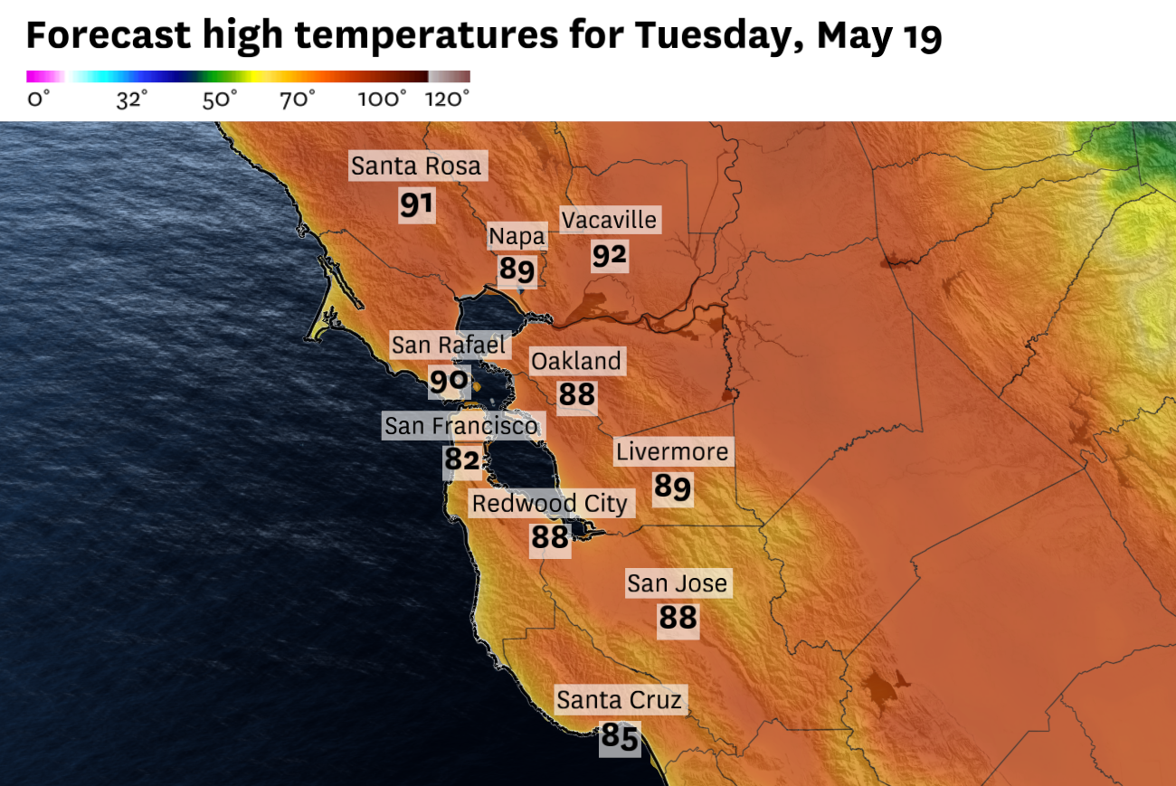
Tuesday will be another hot day in the Bay Area, with most locations reaching into the 80s.
Baron/Lynx
San Francisco will get another shot at 80-degree weather Tuesday after parts of the city reached the 80s Monday. And like Monday, temperatures in the city and around the bay will still depend on how quickly marine air returns in the afternoon.
The Bay Area remains caught between two competing weather patterns: dry air moving around high pressure over the eastern Pacific, and a shallow marine layer trying to rebuild along the coast. That setup will keep inland areas hot again Tuesday, while temperatures near the bay and coast remain more sensitive to wind direction and the timing of the sea breeze.
The warmest spots Tuesday will be inland, where the North Bay and East Bay valleys are expected to climb into the upper 80s and low 90s. Concord, Livermore and parts of Napa County should be among the hotter locations. The South Bay will run a few degrees cooler, though San Jose and much of Silicon Valley should still reach the mid- to upper 80s.
Article continues below this ad
Around the bay, the wildcard is mostly timing. Marine air reached San Francisco around 2:30 p.m. Monday, cutting into the late-day warmup. If that push arrives earlier Tuesday, San Francisco, Oakland, Berkeley and the Peninsula may stay in the 70s. If it holds off until later in the afternoon, low to mid-80s are still possible.
Several days of strong northwest winds along the California coast have also cooled the ocean surface, pulling colder water up from below. That won’t necessarily change Tuesday’s forecast on its own, but it does mean cooler marine air is sitting close by once winds turn more consistently onshore later in the week.
San Francisco Chronicle Logo
Make us a Preferred Source to get more of our news when you search.
Add Preferred Source
Tuesday will also stay dry, especially across the interior. Afternoon humidity should fall into the teens across the North Bay and East Bay valleys and nearby hills, while San Francisco, Oakland and the Peninsula should hold a little higher thanks to some marine influence. The dry air may still be noticeable around the bay, with chapped lips, dry skin, irritated eyes or a scratchy throat possible for people spending time outside.
Tuesday will be very dry, especially across the interior and away from the water.
Baron/Lynx
The dryness should start to ease Wednesday as the marine influence slowly rebuilds, even across inland and higher-elevation areas. That should also help lower fire-weather concerns from Wednesday onward.
Article continues below this ad
Tuesday breakdown
San Francisco: Tuesday will be sunny, dry and warm again, but the afternoon temperatures will depend on when marine air returns. Downtown, SoMa, the Mission and Potrero Hill should reach the upper 70s to low 80s and the Outer Sunset and Richmond District should peak in the low to mid-70s before the sea breeze picks up in the early afternoon. The air will feel dry as relative humidity levels drop into the 20-30% range. Overnight will be clear, calm and mild, with lows in the low to mid-50s.
North Bay: Tuesday will be sunny, dry and hot across much of the North Bay. Santa Rosa, Petaluma, Novato, Napa, Vallejo and Vacaville should climb into the upper 80s to low 90s, with only the immediate coast and parts of bayside Marin running cooler. The air will stay dry, with afternoon relative humidity falling into the teens and 20s across many valleys and nearby hills. Overnight will be clear and mild, with lows mostly in the low to mid-50s.
East Bay: Tuesday will be sunny, dry and hot across most of the East Bay. Oakland, Berkeley, Richmond, Hayward and San Leandro should climb into the mid- to upper 80s before the afternoon breeze increases. Farther inland, Walnut Creek, Dublin, Livermore and Martinez should reach the upper 80s to low 90s. The air will be driest inland, where relative humidity may fall into the low teens, while bayside communities should bottom out closer to the 20% range. Overnight will be clear and mild, with lows in the mid-50s near the bay and low to mid-50s inland.
Article continues below this ad
Pacific Coast and Peninsula: Tuesday will be cooler near the immediate coast, but still warmer than a typical marine-layer day. Pacifica should reach the low to mid-70s, while Half Moon Bay and Moss Beach stay closer to 70. Daly City and South San Francisco should reach the upper 70s to mid-80s, and Burlingame, San Mateo and Redwood City should climb into the mid- to upper 80s before the sea breeze strengthens. The air will feel driest away from the immediate coast. Overnight will be mostly clear and mild, with lows in the low to mid-50s.
South Bay and Santa Cruz: Tuesday will be sunny, dry and warm across the South Bay. San Jose, Sunnyvale, Cupertino, Campbell and Palo Alto should reach the mid- to upp0er 80s, while Morgan Hill and the southern Santa Clara Valley climb into the upper 80s to near 90. Santa Cruz should also be warm for the coast, likely reaching the mid-80s if the marine influence stays weak through the afternoon. Relative humidity will drop into the teens and 20s away from the immediate coast, making the air feel noticeably dry. Overnight will be clear and mild, with lows mostly in the low to mid-50s.