
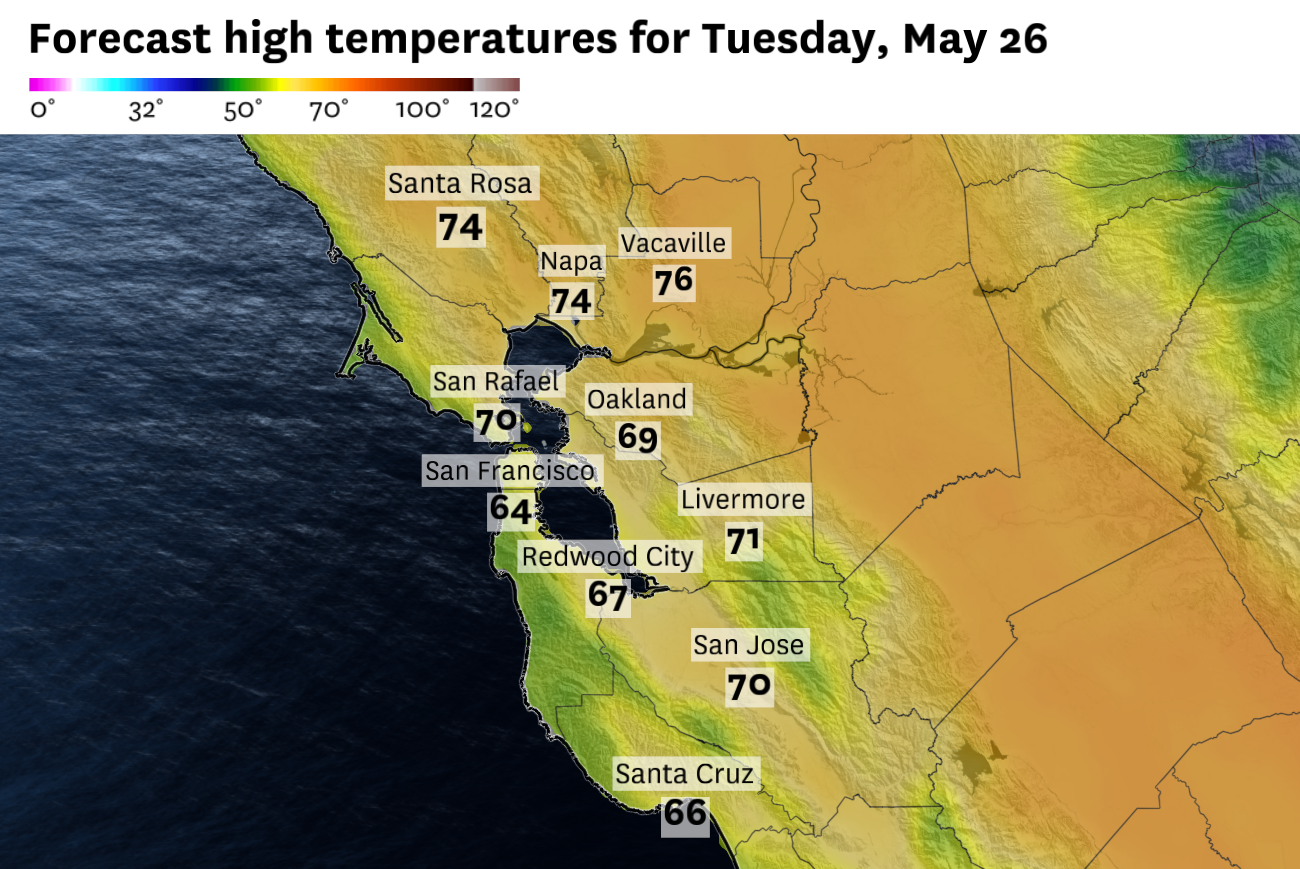
Forecast highs for Tuesday show just how entrenched the cool Pacific air mass will be across the Bay Area. Most shoreline communities stay in the 60s, with inland cities such as Oakland and San Jose hovering near 70 degrees.
Baron/Lynx
Memorial Day weekend is often treated as the unofficial start to summer. The Bay Area’s weather has not exactly followed that script.
Clouds, cool Pacific air and pockets of drizzle will keep Monday feeling more like late spring than early summer across much of the coast, bay shoreline and nearby valleys. Highs will mostly stay in the 50s and 60s near the water, with 70s limited to the warmer inland valleys. Tuesday looks even cooler, with more widespread drizzle, highs mostly in the 60s to near 70, and gusty northwest winds making it feel even chillier.
Pacific air takes over
The ocean influence has been increasing across the Bay Area as the holiday weekend progressed.
Article continues below this ad
A steady onshore wind pushed thicker cloud cover inland Sunday morning and helped keep temperatures cooler through the afternoon. Small eddies spinning near the coast also helped make the pattern a little erratic, turning winds in odd directions at times and nudging clouds into some neighborhoods while others briefly cleared.
Monday morning’s cloud deck looks even deeper and more moisture-laden. Pockets of drizzle are likely along the coast and nearby hills, especially around the Marin Headlands, San Francisco’s west side, Daly City, Pacifica, Half Moon Bay and the Santa Cruz Mountains. Cars, sidewalks and grassy surfaces could be noticeably wet in some of those areas early Monday.
San Francisco Chronicle Logo
Make us a Preferred Source to get more of our news when you search.
Add Preferred Source
Farther inland, most locations will simply be cloudy rather than drizzly. But with a slightly stronger push of cool Pacific air, clouds should clear more slowly than they did Saturday and Sunday, if they clear at all in some coastal and bayside neighborhoods.
The immediate coast will stay the coolest, with highs generally in the upper 50s to low 60s. San Francisco, Oakland, Berkeley and the Peninsula shoreline should mostly stay in the low to mid-60s. Inland areas such as Santa Rosa, Napa, Concord, Livermore, San Jose and Morgan Hill should reach the upper 60s and low to mid-70s, depending on how quickly clouds break.
Article continues below this ad
Tuesday brings the bigger chill
A few days ago, the main weather question for this week centered on an inside slider, a storm system dropping inland through the interior West rather than moving directly in from the Pacific.
These systems often bring dry north or northeast winds to the Bay Area. In warmer setups, that can raise fire weather concerns and send temperatures higher, especially away from the coast.
The inside slider will still develop, but it will not bring a major warmup or widespread Bay Area fire weather concerns. Instead, it will pull colder air into Northern California and make Tuesday the coolest day of the week.
Article continues below this ad
As the storm center heads toward the spine of the Sierra Nevada, a weak cold front will move through the Bay Area before sunrise Tuesday. The front itself will mostly pass through quietly, but it will open the door to colder air sourced from the Gulf of Alaska.
Ironically, Tuesday may bring more afternoon sunshine than Monday in some spots. But temperatures will still be cooler overall. That is because the air several thousand feet above the Bay Area will be unusually cold for late May, running about 10 to 20 degrees below normal. That puts a lid on how much the surface can warm, even in inland areas away from the water.
Drizzle chances will also expand early Tuesday, especially near the coast, the bay shoreline, the Peninsula, the South Bay and parts of the Santa Cruz Mountains. Rainfall totals should be minimal, but the morning could feel damp and raw.
Winds will become gusty by afternoon as the colder air moves in behind the front. Northwest winds could gust 20 to 40 mph, strongest near the coast, through gaps and passes, and across exposed hills. That will make it feel especially chilly in San Francisco, along the East Bay shoreline and across the Peninsula.
Where the storm goes next
The core of the upper-level storm system will drift down the Sierra on Tuesday, then slowly weaken and meander toward the Central Coast on Wednesday and Thursday.
Article continues below this ad
The exact track is still not locked in. Forecast models broadly agree on the general setup, but small shifts in the storm’s position could change how much cloud cover lingers and how quickly temperatures rebound.
For Tahoe and the Sierra, the system will have more obvious impacts. Unseasonably cool temperatures, gusty winds and even some high-elevation snow showers are possible Wednesday and Thursday. Lake wind advisories are also in effect for Lake Tahoe and several western Nevada lakes from Monday into Tuesday, with gusts of 35 to 40 mph and waves of 1 to 4 feet possible.
Farther north and east, fire weather concerns will increase Monday afternoon and evening across parts of northeast California and northwest Nevada, where red flag warnings are in effect. West-southwest winds could gust 40 to 45 mph while humidity drops into the 10% to 20% range, creating the potential for rapid fire spread in valley and midslope fuels.
For the Bay Area, the local impacts look more muted after Tuesday.
Article continues below this ad
A brief push of stronger offshore winds is possible early Wednesday, mainly in the hills and mountains of Sonoma and Napa counties, with some gusts also possible in the East Bay hills. But that offshore wind signal looks short-lived and localized, not the start of a hot, dry pattern.
Instead, Wednesday and Thursday should bring a slow warming trend, especially inland, along with less wind and fewer clouds. The change may be subtle for places that are more sensitive to the marine layer, including San Francisco, the Peninsula and the East Bay shoreline. Those areas could still see a mix of morning clouds and afternoon clearing, while inland valleys notice the warmup more clearly.