
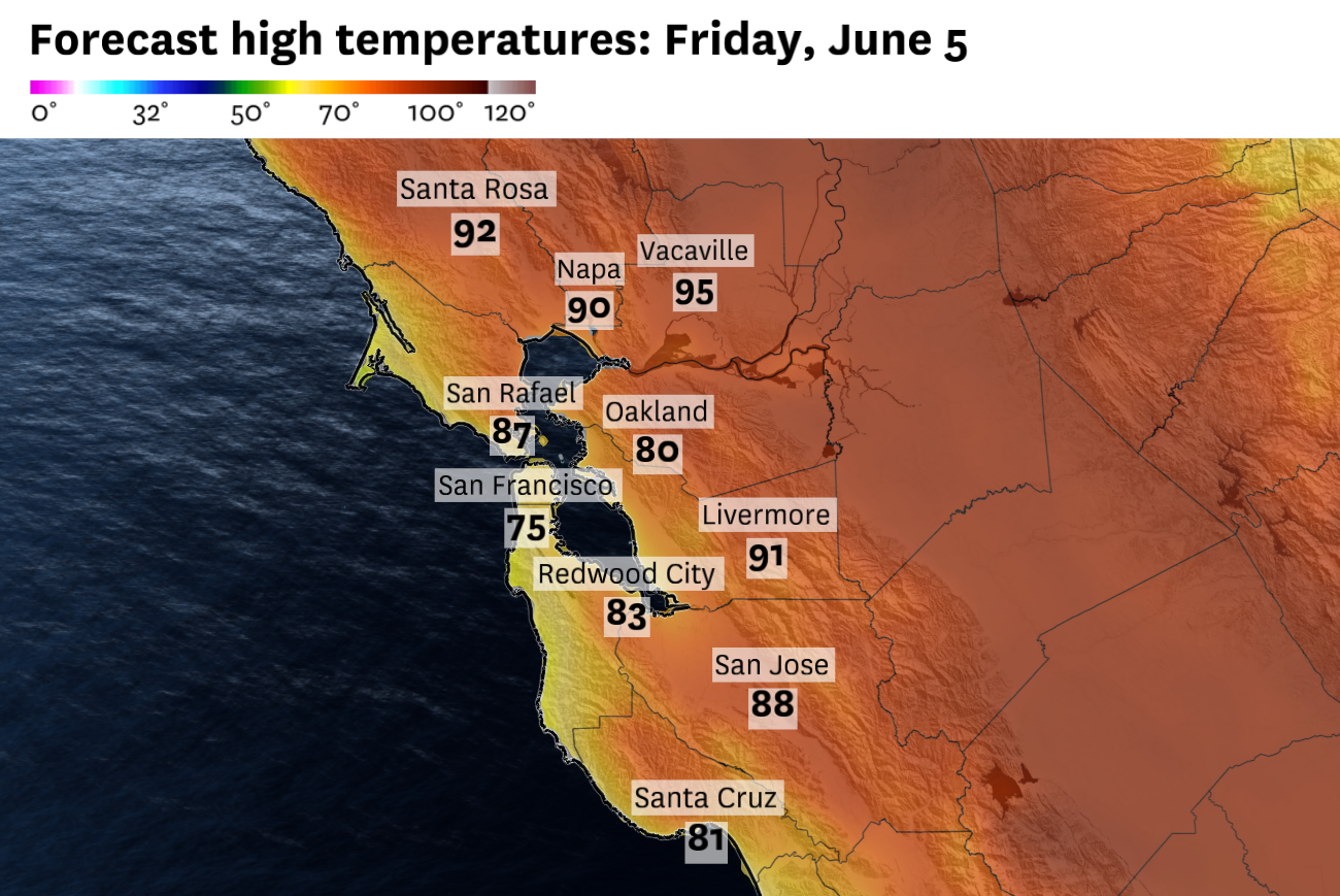
Friday is forecast to be the hottest day so far this year in the Sacramento Valley and parts of the North Bay and East Bay, with temperatures in the 90s. Cities near the Sierra foothills could reach 100 degrees.
Baron/Lynx
Friday is likely to be the hottest day of 2026 so far for inland parts of the Bay Area and Sacramento Valley, but a major cooldown is on the way Saturday — with high temperatures dropping as much as 15 degrees. It will get even cooler next week, and the prospect of a rare June soaking rain is increasing.
Temperatures on Friday will approach triple digits in the hottest parts of Northern California. Chico, Red Bluff, Yuba City, Oroville, Folsom and Roseville have the best chance of hitting 100 degrees, though most parts of the Sacramento Valley are expected to peak in the mid- to upper 90s.
In the Bay Area, low to mid-90s are expected in northern Wine Country, the Tri-Valley and Diablo Valley. Coastal areas will be cooler, in the 60s, with 70s to mid-80s along the bayshore.
Article continues below this ad
Despite the warmth, the National Weather Service warns of hazardous beach conditions due to an elevated threat of sneaker waves and rip currents until Saturday morning.
On Saturday, ocean-chilled winds will pick up and blow across the bay, through the delta and into the Central Valley, as the high pressure system that’s been over California this week weakens.
A low-pressure system over the Pacific Northwest won’t bring rain to California, but it will induce a cooldown Saturday as winds pick up and the hot air mass moves east.
Baron/Lynx
High temperatures could drop by 15 degrees or more in Livermore, Dublin and Walnut Creek, to the mid-70s. Northern Napa, Sonoma and Solano counties have the best chance of 80-degree readings, with 60s and 70s elsewhere. The hottest parts of the Sacramento Valley will be hard-pressed to reach 90 degrees.
High temperatures Saturday are forecast to be as much as 15 degrees lower than Friday, particularly for inland parts of the Bay Area.
Baron/Lynx
Temperatures will flatline Sunday, remaining near seasonal averages. Despite the cool, windy weather, fog is expected to be limited this weekend.
Article continues below this ad
San Francisco Chronicle Logo
Make us a Preferred Source to get more of our news when you search.
Add Preferred Source
On Monday, temperatures are expected to drop below June norms as a low-pressure system approaches the West Coast. Remnants of Tropical Storm Jangmi, which brought heavy rain and wind to Japan earlier this week, will add energy to an active Pacific jet stream and direct a large ribbon of moisture toward California.
This would probably be a textbook atmospheric river rainstorm in winter, but storm systems that help convert water vapor to precipitation are weaker and less frequent this time of year.
A large plume of atmospheric moisture is expected to be aimed at California early next week, though it’s uncertain how much of that water vapor will be squeezed out as rain and snow.
Baron/Lynx
If the low-pressure system is close enough to California, it would help squeeze out rain and even high-elevation snow from the atmospheric river. If the system stays away, only the highest elevations of the coastal ranges and the Sierra Nevada will get wet, and the rest of Northern California will be left with no more than cloudy skies.
Article continues below this ad
Rain chances are best Monday night through early Wednesday. Mild weather will probably linger through Thursday before the potential for the first true heat wave of the year arrives in the middle of June.
Weekend breakdown
San Francisco: Little to no fog is expected this weekend, but the recent spell of strong winds won’t let up. Gusts of 20 to 35 mph are anticipated each afternoon and evening, with Sunday likely to be the breeziest day. Neighborhoods east of Twin Peaks could reach the low 70s Friday, with 60s to the east. Saturday and Sunday will be cooler, with highs in the upper 50s to low 60s in the Richmond and Sunset Districts and low to mid-60s elsewhere. Lows will be in the low to mid-50s.
North Bay: Another 90-degree day is expected Friday in Santa Rosa, Calistoga, Fairfield and Napa. The rest of the North Bay should reach the 80s, save for the immediate coast, which will remain in the 60s to low 70s. Skies will be mostly sunny.
Article continues below this ad
Saturday will mark a sharp cooldown, with increasing winds. Gusts of up to 30 mph are expected, even stronger at the coast, with temperatures plummeting 10 degrees or more from Friday’s highs. A bike ride across the Golden Gate Bridge or in Wine Country will be clear, but crosswinds will be intense. Similar weather is expected Sunday. Overnight lows will be in the low to mid-50s each night.
East Bay: Friday will be the last day of well above-normal temperatures for at least the next week. Highs are expected to reach the low 90s east of the Caldecott Tunnel, and potentially as high as the mid-90s in Antioch and Brentwood. Cities closer to the bay, including Berkeley, Oakland, Hayward and Fremont, will max out in the mid-70s to low 80s.
A stronger breeze blowing off the bay will keep Saturday much cooler. Highs are expected to fall to the 60s along the bay shoreline and the 70s inland. Gusts up to 30 mph are possible. Another mild, breezy day is expected Sunday, though temperatures may bounce back slightly, to the low 80s in the warmest inland cities. Overnight lows will be in the 50s through the weekend, with only patchy fog near the bay, most likely Sunday morning.
Pacific Coast and Peninsula: There won’t be much fog at the beaches this weekend, but a beach hazards statement is in effect until 9 a.m. Saturday for the threat of sneaker waves and rip currents. Highs in Daly City, Pacifica and Half Moon Bay through Sunday will be in the upper 50s to low 60s, possibly the mid-60s on Friday.
Mostly sunny skies are expected all weekend along the Highway 101 corridor, with only a slight chance of patchy morning fog. Highs Friday will be in the upper 60s to upper 70s between South San Francisco and Redwood City, coolest to the north and warmest farther south. Temperatures will drop about 5 to 10 degrees Saturday, to the 60s everywhere, before bouncing back slightly Sunday. Gusts could exceed 40 mph through the San Bruno Gap on Saturday, with frequent gusts up to 30 mph at the beaches. Lows will be in the low 50s.
Article continues below this ad
South Bay and Santa Cruz: Friday will easily be the hottest of the next three days. Highs will be in the mid-80s to low 90s in Santa Clara Valley, coolest near the bay in Milpitas and Mountain View and warmest in Morgan Hill and Gilroy. San Jose should fall in the middle. Similar temperatures are expected in the Santa Cruz Mountains, with 70s to low 80s in Santa Cruz.
Saturday and Sunday will be much cooler, with highs dropping as much as 15 degrees. Most places will be in the 70s, though skies will remain sunny. Morning fog is unlikely this weekend, but if it does form it should burn off quickly. Gusts of 20 to 35 mph are expected Saturday, with slightly weaker winds Sunday, though remaining breezy. Overnight lows will be in the upper 40s to low 50s throughout the weekend.