
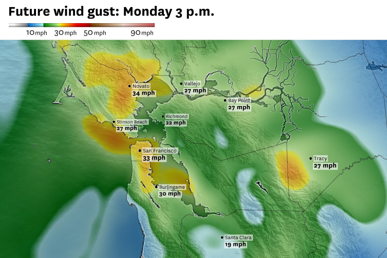
Monday afternoon wind gusts could reach 25 to 35 mph in exposed parts of the Bay Area, including the coast, North Bay hills, San Francisco and portions of the Peninsula.
Baron/Lynx
The Bay Area enters the second week of June on a cooler note, with a brief period of elevated fire weather concerns for parts of the North Bay and East Bay hills followed by a warmup that still has a lot of uncertainty, especially for San Francisco.
Interior parts of the North Bay and East Bay could climb into the 90s by Wednesday and approach 100 degrees by Thursday and Friday. The bigger uncertainty is closer to the water, where San Francisco, the coast and parts of the bay shoreline will depend on how much the marine layer and afternoon sea breeze hold on.
The pattern will also bring a brief period of elevated fire weather concerns, mainly for the North Bay and East Bay hills, though the more organized fire weather risk is expected north and east of the Bay Area.
Article continues below this ad
A cool and breezy start to the week
The shift stems from an active and somewhat unpredictable Pacific jet stream. The jet stream will help spread cooler air across the West Coast and much of California early in the week while also generating a storm system poised to move through the Pacific Northwest. By midweek, high pressure building behind that system will start pushing temperatures higher across the Bay Area.
The Bay Area won’t feel much of that pattern change Monday morning. But that will change by the afternoon, as northwest wind gusts of 20 to 30 mph develop and wispy high-altitude clouds increase ahead of a weak cold front approaching from the west.
San Francisco Chronicle Logo
Make us a Preferred Source to get more of our news when you search.
Add Preferred Source
That cold front will quickly sweep through the region late Monday, with gusty winds spreading across the interior North Bay and East Bay. Light rain showers are likely along the Marin coastline and in the Marin and Sonoma hills. Santa Rosa and Petaluma could pick up around a tenth of an inch of rain.
Article continues below this ad
Some drizzle is also possible along the western side of San Francisco and down Highway 1 through Half Moon Bay. Everywhere else should stay dry. Even in places that pick up drizzle, rainfall amounts will be negligible, generally less than 0.05 of an inch.
How hot will it get?
Winds will weaken Tuesday, and temperatures will warm by a few degrees as the cooler atmospheric pattern starts to shift east.
The bigger change arrives Wednesday, when high pressure begins building over the eastern Pacific. That will push the cooler pattern inland and allow temperatures to rise sharply across the Bay Area. The warmup will be most noticeable away from the coast, especially in the North Bay, East Bay and interior valleys, where afternoon highs could climb well into the 90s.
Thursday and Friday currently look like the warmest days of the week. Parts of the interior East Bay could approach or reach 100 degrees, including Concord, Walnut Creek and Livermore. The warmest parts of the North Bay, including Santa Rosa and Vacaville, could also climb into the upper 90s to around 100 degrees.
Article continues below this ad
Thursday is expected to be the warmest day of the week, with inland parts of the North Bay and East Bay approaching 100 degrees while the coast stays cooler.
Baron/Lynx
The immediate coast and San Francisco remain the hardest parts of the forecast. A stronger ridge would usually favor warmer weather, but the exact position of the high-pressure system matters. If the ridge sets up far enough offshore, the marine layer and afternoon sea breeze could keep San Francisco and the beaches closer to seasonal levels. If the ridge shifts inland or weakens the onshore flow more aggressively, temperatures could jump faster, including around the bay shoreline.
Fire weather risk increases
Fire weather concerns look uneven this week. In the Bay Area, the main risk is limited to a few windows of locally gusty north to northeast winds over the North Bay and East Bay hills, especially late Tuesday night into Wednesday and again around Thursday. Humidity levels will fall as high pressure builds, but the strongest winds and driest air may not overlap for long.
The better fire weather signal is north and east of the Bay Area, including the Sacramento Valley, foothills and nearby terrain gaps. A fire weather watch is in place there from Wednesday through Friday, when gusty northerly winds will overlap with lower humidity and higher temperatures.
Article continues below this ad
The Storm Prediction Center highlights parts of the Sacramento Valley and adjacent foothills for elevated fire weather concerns starting Wednesday, while the Bay Area remains outside the main risk area.
NOAA
Thursday looks like the most likely peak of the risk, as the offshore pattern becomes better established and humidity levels fall across interior Northern California. The forecast still hinges on wind timing. If winds hold as the air dries, fire weather concerns will increase, especially in the foothills.
Monday breakdown
San Francisco: Monday morning will start with a mix of sun and clouds across the city and a need for a light jacket with temperatures in the 50s. As the day progresses, clouds and wind gusts will increase as a weak cold front approaches the coast. High temperatures should reach the low to mid-60s across most neighborhoods, with upper 50s to low 60s near Ocean Beach and, the Sunset and Richmond districts. Wind gusts from the northwest peak in the afternoon and evening at around 10 to 25 mph. Mostly cloudy overnight with a chance at some drizzle or a light rain shower after midnight, mainly in the west-facing hills of the city. Lows will be in the 50s.
North Bay: Monday will be mild but breezy, with highs in the mid-70s around San Rafael, Petaluma and Napa, and upper 70s to near 80 in Santa Rosa and Napa. The Marin coast will be much cooler and cloudier, with highs generally in the 50s and 60s. Clouds will build in from the northwest in the afternoon along with increasing winds, with gusts of 25 to 35 mph possible in exposed coastal areas, hills and gaps. Drizzle and light showers are possible late Monday into early Tuesday, mainly along the Marin coast, Sonoma coast and interior hills. Lows will be in the 50s.
Article continues below this ad
East Bay: Monday will be warm and breezy, with highs in the low 70s near Oakland, Berkeley and Fremont. Inland areas will be warmer, with upper 70s near Concord and mid-70s around Livermore and Dublin. West winds pick up Monday afternoon, gusting from 20 to 35 mph, with higher gusts in the hills. Overnight will be mostly cloudy and breezy with just a slight chance of a shower along the bayshore and lows in the 50s.
Pacific Coast and Peninsula: Some brief spots of sunshine will pop out along the Pacific coast Monday morning before mostly cloudy conditions set in. Highs will be around 60 degrees in Pacifica and Half Moon Bay. Across the Peninsula, a bit more sunshine should help push temperatures into the mid-60s in South San Francisco and at San Francisco International Airport, with highs pushing 70 degrees in Redwood City. Northwest winds will be strong Monday afternoon, especially through the San Bruno Gap and other favorable spots where gusts may eclipse 40 mph. Most of Monday evening should stay dry, but drizzle or a light shower is likely after midnight along the Peninsula coast, especially near Pacifica, Half Moon Bay and other west-facing coastal areas.
South Bay and Santa Cruz: Monday will be mild and sunny in the South Bay before clouds and winds arrive late in the afternoon. Highs should reach the low to mid-70s in San Jose and Santa Clara, and the upper 70s near Morgan Hill and Gilroy. Coastal Santa Cruz will top out around 70 degrees. Afternoon winds will increase, but the strongest gusts should stay closer to the coast and in the Santa Cruz Mountains. Clouds increase Monday night, with a slight chance of drizzle or a brief light shower mainly in the Santa Cruz Mountains after midnight.