
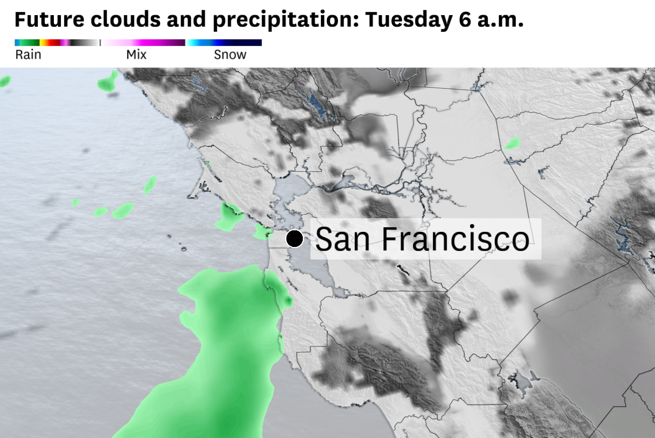
Drizzle is possible in San Francisco, the Santa Cruz Mountains and East Bay hills on Tuesday morning. Sunshine is expected to emerge midday as drier air pushes into the Bay Area.
Baron/Lynx
Bay Area weather will shift rapidly this week — and not just the temperatures.
Humidity is forecast to swing wildly the next few days, as a foggy, drizzly Tuesday morning is wiped out by warm, dry winds Wednesday.
Tuesday will probably mark San Francisco’s first foggy morning in a while as cool, humid ocean winds blow across the city and extend all the way to Oakland. Drizzle is possible in parts of the Bay Area, particularly hilly neighborhoods in San Francisco, the Oakland and Berkeley hills, the Pacific Coast and Santa Cruz Mountains.
Article continues below this ad
Relative humidity is forecast to be high Tuesday morning, with low clouds and fog across much of the Bay Area.
Baron/Lynx
Even where it isn’t drizzling, skies are expected to be partly to mostly cloudy until noon, with the best chance of morning sunshine in the North Bay and in the interior East Bay. Drier winds will work their way in during the afternoon, with completely clear skies expected by sunset. Highs will be in the low 60s at the coast, mid-60s to low 70s along the bay shoreline and mid-70s to mid-80s inland, hottest in the North Bay.
Wednesday will be sunny from the start, unlike Tuesday.
San Francisco Chronicle Logo
Make us a Preferred Source to get more of our news when you search.
Add Preferred Source
Morning relative humidity is forecast to be close to 80% near San Francisco Bay and below 70% inland, limiting the potential for fog. The air will be even drier in the hills, preventing clouds. By afternoon, relative humidity is forecast to plummet below 20% inland as temperatures rise and dry northerly winds kick in, increasing fire danger.
Article continues below this ad
Relative humidity is forecast to plummet below 20% away from the coast Wednesday. Dry winds will increase fire danger as temperatures climb to the 90s.
Baron/Lynx
Temperatures are forecast to reach the 90s inland, the 70s and 80s along the bay shoreline and 60s at the coast — 10 to 15 degrees higher than Tuesday.
Tuesday night will be the best chance to open windows for cool, fresh air, because Wednesday night is expected to be the warmest night so far this year in many cities. Overnight lows are forecast to remain in the 60s in most areas, with 70s in the hills above about 500 feet.
The National Weather Service advises of a moderate to major risk of heat-related illnesses later this week as triple-digit temperatures become likely Thursday. Infants, elderly and people with underlying health conditions are most likely to be affected by this level of heat.
Fog is expected to roar back into San Francisco on Friday, though hot, dry weather is anticipated to last through the weekend in the Santa Clara Valley, Wine Country, the interior East Bay and the Sacramento Valley.
Article continues below this ad
Tuesday breakdown
San Francisco: Thick fog is expected at sunrise, with the best chance of drizzle in the Richmond and Sunset districts, Golden Gate Heights, Diamond Heights and Twin Peaks. Skies will gradually clear, turning mostly sunny by mid-afternoon. Highs will be in the low to mid-60s west of Twin Peaks and the mid- to upper 60s to the east, including downtown. Gusts of 15 to 25 mph are likely in the afternoon. A clear night is expected with lows in the low to mid-50s.
North Bay: Chances for drizzle, most likely in Marin County, will fade quickly after sunrise. Morning clouds will give way to afternoon sunshine, though high temperatures will depend on exactly how rapidly clouds clear. Highs are expected to be in the mid- to upper 70s in Mill Valley, San Rafael, Petaluma and Vallejo and the low to mid-80s in Santa Rosa, Napa, Calistoga, Fairfield and Vacaville, though temperatures may vary about 5 degrees from forecast. Gusts up to 20 mph are possible in the afternoon. It’ll be clear overnight, with lows in the 50s.
East Bay: Residents in the Oakland and Berkeley hills may wake up to drizzle as a thick fog pushes across the bay into the Interstate 580 and I-80 corridors. Gradual morning clearing will give way to afternoon sunshine. Highs will be in the upper 60s to mid-70s along the bay shoreline, and upper 70s to low 80s in Lamorinda and the Tri-Valley and the low to mid-80s in Walnut Creek, Concord, Antioch and Brentwood. Gusts up to 20 mph are possible in the afternoon. Overnight lows will be in the 50s under starry skies.
Article continues below this ad
Pacific Coast and Peninsula: A drizzly, foggy morning is expected at the coast, with mostly cloudy skies extending toward the Highway 101 corridor. Sunshine should prevail in the afternoon, with increasing winds, gusting up to 35 mph through the San Bruno Gap and 15 to 25 mph elsewhere. Highs will be in the low 60s in Daly City, Pacifica and Half Moon Bay, the mid- to upper 60s in South San Francisco and San Bruno and the low to mid-70s in San Mateo, San Carlos and Redwood City. A clear night is expected, with lows in the low to mid-50s.
South Bay and Santa Cruz: The morning will be overcast with a chance of drizzle in the Santa Cruz Mountains. Gradual clearing is expected with abundant sunshine by mid-afternoon. The slow clearing will keep temperatures near to slightly below normal, with highs in the low to mid-70s, with upper 70s possible in Morgan Hill, Gilroy and Santa Cruz. Gusts will be around 15 mph in the afternoon. A clear night is expected, with lows in the 50s.