
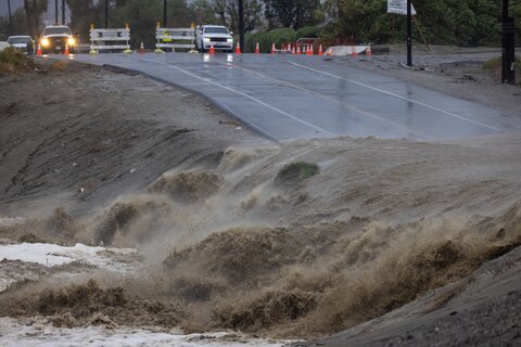
Climate change could make historically rare tropical storms in Southern California produce significantly more precipitation in the next few decades, and when they strike, landslides are likely to become a bigger risk across the region, according to new research in Nature Climate Change.
The study, published June 10 by scientists from Stanford, MIT, and Western Michigan University, finds exposure to landslide risk is likely to grow fastest among low-income households.
Tropical cyclone risk has long been overlooked in Southern California because the storms have been relatively rare. In the summer of 2023, Hurricane Hilary demonstrated the damage these storms can cause when its remnants swept gale-force winds and torrential rain into the region.
The record-breaking rainfall caused closed roads, flash floods carried away cars, and landslides caked homes in mud, costing more than $900 million in damages.
“Hurricane Hilary reminded people that Southern California is not immune to tropical cyclones and related flooding and landslides,” said Yuan Wang, assistant professor of Earth system science at the Stanford Doerr School of Sustainability and a senior author of the new study.
Understanding ‘grey swan’ storms in Southern California
In the United States, hurricanes have mostly imperiled people living near the Atlantic and Gulf coasts, where emergency alerts are well established, and people have learned to board up their windows and pile sandbags around storefronts. People living in Southern California tend to have less experience with tropical storms.
Scientists refer to this type of unusual, high-impact storm as a “grey swan,” a term coined by co-author Kerry Emanuel in an earlier study. Whereas a “black swan” would be an extremely consequential and nearly unforeseeable event, “grey swans” can’t be precisely predicted from historical data but can be anticipated based on available physical knowledge of the climate system.
For Wang, who lived in Southern California for years, the genesis for the new study was personal. He had moved away only months before the storm that began as Hurricane Hilary hit and saw images of muddied homes and flooded streets in his old neighborhood.
Knowing that scientists were still unsure how much worse such storms could become in a warming climate, Wang brought researchers together to focus on the future of storms like Hilary in the state and to understand the scale of the risk when the next one strikes. “The question is not whether or not we will have a hurricane in Southern California, but how large the risk can be,” he said.
How warming oceans connect to extreme rainfall
Warm waters fuel hurricanes, and Southern California has long enjoyed protection from the cool ocean temperatures in the northeastern Pacific. But temperatures in the Eastern Pacific have risen in recent decades, providing energy to the atmosphere. Climate patterns such as El Niño can warm surface temperatures across much of the Pacific even further, creating conditions favorable to storms.
Warmer air also holds more moisture and contributes to greater atmospheric instability. When those storms reach the coast, California’s mountains force air upward. As it cools at higher elevations, the moisture condenses and can produce heavy rainfall.
Climate change is intensifying Southern California’s flash floods, drought, and wildfires. When heavy rain falls, dry, unstable soil can’t absorb it. Streets flood, and slopes slip away. “The condition can shift from one extreme to the other very quickly,” Wang said.
Wang and a group of experts in cloud physics, extreme weather, and geography set out to investigate the chain of factors, from storm formation over the Pacific to people living on Southern California hillsides, and account for conditions of climate change.
“Many of the greatest risks from climate change result from the emergence of events that are more extreme than the historical climate that our infrastructure and disaster management systems were designed for,” said study co-author Noah Diffenbaugh, the William Wrigley Professor and Kimmelman Family Senior Fellow in the Doerr School of Sustainability.
More people and places threatened by landslides
The scientists used climate models to replicate large-scale conditions, then applied a technique called downscaling to generate thousands of possible storms and track which ones might reach Southern California, and how intense the precipitation could be.
The average Eastern Pacific sea surface temperature could rise 2.7 degrees Celsius from 1985-2014 to 2071-2100, according to the new climate model projections, making extreme rainfall events twice as likely to strike Southern California.
Historically, storms capable of producing more than 100 millimeters (about 4 inches) of rainfall like Hurricane Hilary have a probability of hitting California approximately once a century, commonly called a 100-year storm. The scientists found that the probability could double with continued climate change. Different models produced varying estimates, and risks are lower in scenarios with lower emissions and less warming, Wang noted, but all consistently pointed in the same direction. “Heavy rainfall induced by tropical cyclones will be more likely to happen.”
Wang and colleagues fed their rainfall estimates into a landslide model. Every California county tested shows growth in the total area exposed to landslides between 2000 and 2050. The results indicate that more than 75% of Los Angeles County will face exposure to severe landslide risk if greenhouse gas emissions continue under one of the more extreme but realistic climate scenarios. Other densely populated counties, including Orange, San Diego, and San Bernardino, also show large increases in the percentage of their populations living in high-risk landslide zones, especially in mountainous areas.