
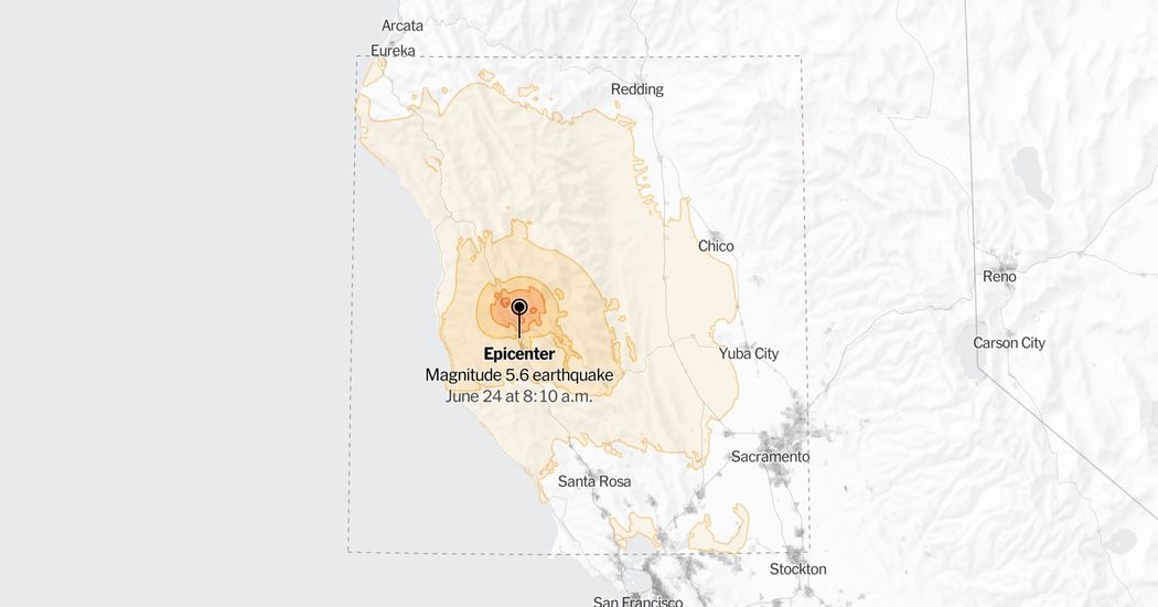
Note: Map shows the area with a shake intensity of 3 or greater, which U.S.G.S. defines as “weak,” though the earthquake may be felt outside the areas shown. All times on the map are Pacific time. The New York Times
A moderately strong, 5.6-magnitude earthquake struck in Northern California on Wednesday, according to the United States Geological Survey.
The temblor happened at 8:10 a.m. Pacific time about 7 miles north of Redwood Valley, Calif., data from the agency shows.
People as far away as Eureka to the north and Sacramento to the southeast reported to the U.S.G.S. that they felt some shaking from the earthquake. Some closest to the epicenter described it as very strong.
About 7,400 homes and businesses in Mendocino County were without power, according to Poweroutage.com, which tracks utilities.
Phones across Northern California and into Oregon buzzed with notifications from ShakeAlert, the United States Geological Survey system that detects earthquakes as soon as they begin and feeds the popular MyShake app.
“MyShake absolutely worked for this event and it alerted a large number of people in a short amount of time,” said Suresh Raman, manager of the MyShake app at the UC Berkeley Seismology Lab. Mr. Raman said that an estimated 650,000 people received the alert.
Preliminary findings indicated that 99 percent of the people who received the alert got it before they felt shaking, if they felt the quake at all. Mr. Raman said that those in San Francisco got an estimated 35-second warning.
Aftershocks detected
Subsequent quakes have been reported in the same area. Such temblors are typically aftershocks caused by minor adjustments along the portion of a fault that slipped at the time of the initial earthquake.
Quakes and aftershocks within 100 miles
Aftershocks can occur days, weeks or even years after the first earthquake. These events can be of equal or larger magnitude to the initial earthquake, and they can continue to affect already damaged locations.
When quakes and aftershocks occurred
All times are Pacific time. The New York Times
As seismologists review available data, they may revise the earthquake’s reported magnitude. Additional information collected about the earthquake may also prompt U.S.G.S. scientists to update the shake-severity map.
Sources: United States Geological Survey (epicenter, aftershocks, shake intensity); LandScan via Oak Ridge National Laboratory (population density) | Notes: Shaking categories are based on the Modified Mercalli Intensity scale. When aftershock data is available, the corresponding maps and charts include earthquakes within 100 miles and seven days of the initial quake. All times above are Pacific time. Shake data is as of Wednesday, June 24 at 11:20 a.m. Eastern. Aftershocks data is as of Thursday, June 25 at 10:56 p.m. Eastern.