
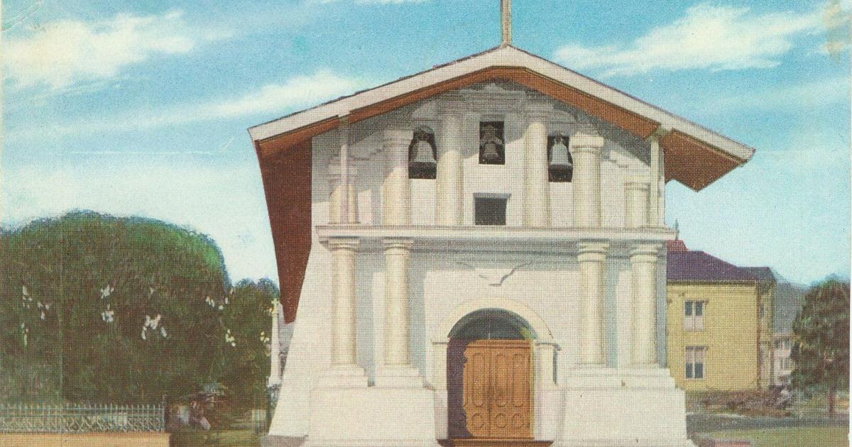

A vintage postcard commemorating the existing Mission Dolores, which was finished in 1791. The first iteration was built in 1776.
Relinus/Creative Commons
For San Francisco, 2026 is a double birthday. Not only is this year the 250th anniversary of the founding of the United States; it’s the 250th anniversary of the founding of San Francisco. On June 27, 1776, just seven days before the Founding Fathers signed the Declaration of Independence in Philadelphia, a party of Spanish colonizers under the command of Juan Bautista de Anza’s lieutenant, José Joaquín Moraga, arrived near the site of present-day Mission Dolores. Moraga was following in the footsteps of Anza, the great Spanish explorer who three months earlier had camped at Mountain Lake in what is now the City’s Richmond District and chosen the sites for the Mission and the Presidio, the two indispensable institutions of Spanish colonization. San Francisco, the furthest-flung outpost of the vast Spanish empire, had been born.
Of course, the Declaration of Independence was a far more momentous event than Spain’s colonizing of an unknown place at the ends of the earth. The once-mighty Spanish empire was already in terminal decline, and in less than 50 years it would lose not just Alta California, but almost all of its New World colonies. One anniversary commemorates the birth of a nation that would come to dominate the world; the other marks the last gasp of a dying empire. And yet the Spanish colonization of San Francisco meant much more than that. It was a signature moment in the Hispanic settlement of the American West, a phenomenon that helped make America what it is today.
Making this anniversary still more noteworthy is that Mission Dolores, the most important and well-preserved Spanish site in San Francisco, has a history so rich, varied and dramatic that it is a veritable microcosm of the City’s entire history. From the tragic destruction of the California Indians — predominantly from the Ohlone, Miwok and Patwin tribes — to the brief heyday of the little-known Dolores colony to the madness of the Gold Rush to the Mission Plank Road that opened the area to development to its residents’ heroic role in the 1906 catastrophe to ongoing demographic changes to the upscale, AI-driven neighborhood of today, Mission Dolores and its surroundings have been at the center of many of the most colorful and important events in the City’s history.
A 1857 Mission Bay View looking down Center Street to the east
Schein & Schein Old Maps
When Anza arrived in San Francisco after an arduous 1,200-mile trek from what is now Arizona, he was venturing into terra incognita. California was literally a blank spot on maps. The explorer Juan Rodríguez Cabrillo had claimed it for Spain in 1542, but for more than 200 years the Crown had ignored its putative possession. It took alarming reports of a Russian incursion to spur Spain into finally doing something with its forgotten holding. In 1769, the Crown dispatched a “Sacred Expedition,” led by Father Junípero Serra and the soldier Gaspar de Portolá, that journeyed north from Mexico. They established a chain of missions and forts, or presidios, stretching up the coast from San Diego. Those two indispensable institutions reflected the double purpose of the Sacred Expedition: The forts would cement Spanish control of California, while the missions were aimed at an even more important goal: the conversion of the California Indians to Christianity. Anza’s task was to find the site for the northernmost mission and presidio, the 20th in the chain, to be established somewhere near San Francisco Bay.
Mountain Lake was close to the mouth of the Golden Gate, and Anza selected a strategic site for the presidio above a white cliff that used to stand above present-day Fort Point. He and his party then rode a few miles south, probably along what is now the Van Ness corridor. After turning west they arrived at a lovely spot on the banks of a creek, fed by a nearby waterfall, which they decided would be a good location for the future mission. Because it was the Friday of Sorrows, they called the creek the “Arroyo de los Dolores.” This is where the first humble version of Mission Dolores — its full name is Misión San Francisco de Asís — would be built.
The exact location of this site is a matter of controversy. Until recently, it was thought to be located on a now-vanished lake near present-day Camp and Albion streets, close to Valencia and 17th streets. But Christopher Richard, a Bay Area biologist and water expert, has made a convincing case that the supposed lake never existed and that the site of the first mission was actually located two-thirds of a mile to the northwest, on a creek near Sanchez and 14th streets. Wherever it was, three months later, on June 27, Anza’s lieutenant, Moraga, arrived there with a larger party of soldiers, settlers and servants from Monterey. Here they built a small chapel made of branches — San Francisco’s first building. And on June 29, 1776, the feast day of St. Peter and St. Paul, they celebrated the first mass in San Francisco.
A 1851 letter sheet titled Mission Dolores published by Quirot & Co.
Schein & Schein Old Maps
Over the next six years, two larger churches would be built. The exact location of those buildings is unclear, but it was probably five blocks east, at Mission and 14th streets. In 1783, the Spanish decided to relocate the mission to its present location at 16th and Dolores. In 1788, construction on the new mission began, and it was dedicated on April 2, 1791.
Mission Dolores still stands, but the way we think of it has changed forever. Spain’s attempt to convert the California Indians to Christianity was once celebrated as a romantic episode in the state’s colorful Hispanic past; it is now recognized as a tragedy. Father Serra and the priests under him believed they were saving their charges’ souls. But their project completely failed — and the result was mass death and the destruction of an entire culture.
To convert the California Indians, the Spanish convinced and lured tens of thousands of them to come into the missions. After 10 years, those who were converted, called neophytes, were expected to become fully functioning mini-Spaniards, or gente de razón — “people of reason” — and assume ownership of the mission lands that were being held in trust for them.
The project failed. Although the Spanish succeeded in baptizing more than 54,000 California Indians, teaching them the basic tenets of Christianity and putting them to work, almost none of them ever became independent. This was not surprising. For people who were accustomed to roaming freely across the land, who had a casual attitude toward sex and worked only when they needed to, the regimented, by-the-clock life in the missions was like being imprisoned in an extremely devout concentration camp. The leader of a Russian expedition that visited San Francisco in 1816 wrote of the California Indians at Mission Dolores, “I have never seen one laugh. I have never seen one look one in the face. They look as though they were interested in nothing.”
Because of Mission Dolores’ cold climate and inadequate food, the death rate there was the highest of any mission in the chain. In 1825, the California Indian population at Mission Dolores peaked at 1,252 people. By 1830, it had dropped to just 219. When Mexico secularized the missions in 1834, 13 years after winning independence from Spain, only a few hundred California Indians lived on the entire San Francisco Peninsula. They had died of disease and malnutrition; many no doubt died of misery. This grim legacy is hidden under the streets surrounding the peaceful Mission Dolores cemetery, where some 5,000 people, mostly members of various local Ohlone tribes, are buried. It is a dark chapter at the very beginning of the City’s history.
Meanwhile, the area around the Mission was evolving. When Mexico secularized Mission Dolores, it was a decaying place, a compound composed of a few moth-eaten outbuildings surrounding the old adobe church. After secularization, a small colony known as Dolores sprang up there. This fascinating but little-known quarter was largely distinct from its better-known counterpart on the waterfront, Yerba Buena — the hamlet that started in 1835 when a runaway British whaler named William Richardson erected a crude lean-to in what is now Chinatown. Most, but not all, of Dolores’ inhabitants were so-called Californios (Spanish speakers born in California, most of Hispanic descent). A number of the area’s most prominent Californio families, including the Bernals, the de Haros, the Guerreros and the Valencias, lived in adobe buildings in Dolores. For these Californios, the secularization of Mission Dolores was a boon: A number of them received vast grants of land the church had held in trust for the California Indians.
After 1835, the formerly moribund area began to come back to life. Many of the Mission buildings were repurposed: A mill and a soldiers’ barracks were turned into residences, and part of the Mission quadrangle was turned into an inn and tavern. Some neophyte California Indians lived in Dolores, and in the 1830s many retired soldiers from the Presidio moved to the quarter, increasing its population. By 1850, there were more than 50 adobe buildings in Dolores — more than existed when the Mission was functioning. The neighborhood occupied the area bounded by 14th and 19th streets and Mission and Church streets — 20 square blocks — and was inhabited by more than 100 people.
With the old Presidio abandoned, Dolores and its larger (but still tiny) counterpart Yerba Buena constituted what would become San Francisco. But the two tiny neighborhoods were moving in different directions: Yerba Buena was the future, Dolores the past. As Randall Dean wrote in a study of the neighborhood, “The Mission Dolores area was becoming a refuge for Californio families who were increasingly economically, politically and culturally marginalized by the events that transformed the region in the later 1840s.”
The story of Ann Francis Moses and Eustaquio Valencia epitomizes the cross-currents that buffeted the Dolores quarter and illustrates its decline. Moses was a 12-year-old Mormon girl who arrived with her family in San Francisco in 1846 aboard the ship Brooklyn. Because the Moses family had been disgraced by a shipboard polygamy scandal, they were unable to live in Yerba Buena with the other Mormons and were forced to move to the Dolores colony, more than two miles to the southwest. There Moses met a young Valencia from an illustrious Californio family that traced its lineage back to the Anza expedition. Valencia’s father, Candelorio, had been granted the 3,229-acre Rancho Acalanes near present-day Lafayette. At the time, it was unheard of for a white woman to marry a Californio man, but because Valencia could still claim to be landed gentry, and probably also because Moses’ family had been disgraced, Moses’ parents approved the match and the unlikely pair were married at Mission Dolores in 1850. Valencia’s family was on a downward trajectory — his father lost his rancho and was listed in city directories as a laborer — but he navigated the new Anglo world as best he could. After Moses died of tuberculosis at age 24, Valencia remarried into another leading Californio family. He lived in the Valencia family adobe on Dolores Street until a bank foreclosed on it. The old adobe collapsed in a storm in 1878. By 1899, even its ruins had vanished, as had most of the old Hispanic hamlet of Dolores.
For residents of the future San Francisco’s other hamlet, Yerba Buena, the crumbling old Mission Dolores and its environs were a weekend destination, a place to go for a Sunday picnic or to pursue earthier pleasures. Even before the Gold Rush, and for some years after, the Dolores quarter had a piquant reputation. It featured a number of saloons and inns, including a famous 1850 saloon started by a longtime Yerba Buena character and lush named Robert Ridley. Ridley’s ironically named “Mansion House” was located inside the old outbuilding just to the north of the Mission and was famous for its potent milk punches. The Dolores area also boasted more grisly attractions: bullfights, and their even more brutal cousins, bear-and-bull fights. These latter contests, which dated back to early Spanish days, usually ended with the death of the bull. After the Gold Rush, moral outrage over the bear-and-bull fights grew, and the last one in the Dolores quarter took place in 1855.
Those who ventured out to the sticks by the old Mission could also enjoy horse races. A horse race at “the Mission Dolores course” was reported in March 1848, just above a brief item about the supposed discovery of gold on the American River — a story that would bring the city of San Francisco into existence and change American history. San Franciscans were mad for horse racing, and after the Gold Rush the thousands of Argonauts who rushed into town provided a robust customer base. But as was invariably the case in San Francisco, development was blocked by geography — specifically, the two-plus miles of deep sand that lay between downtown and the Mission.
That obstacle was overcome, and the Mission District made accessible, by San Francisco’s first major infrastructure project: the Mission Plank Road, which ran from Portsmouth Square to near Mission Dolores. This privately financed road not only made it possible for thousands of San Franciscans to ride out to watch the horse races at two competing Mission District tracks; it opened the entire area to development. Cattle ranches were replaced by farms, farms were replaced by houses, streets were laid and businesses opened. In just a few decades, the once-bucolic Mission District became an integral part of the city of San Francisco, although the area west of the Mission continued to be sparsely settled into the 1880s.
During the worst catastrophe ever to befall an American city — the 1906 earthquake and fire — the neighborhood near Mission Dolores played a starring role in an extraordinary saga of civic heroism. As the fires raged south through the Mission, threatening to climb 20th Street and burn the entire neighborhood, a single fire hydrant at the corner of 20th and Church was found to be working. As exhausted firemen began trying to pull their heavy engine up Dolores Street, 300 men from the neighborhood, including refugees who were camped in Dolores Park, ran to help them, yelling like soldiers charging into battle. After more than an hour, they managed to drag the engine up to the hydrant. A great jet of water shot out. Finally armed, the firemen, joined by 3,000 San Franciscans, fought the inferno. It took seven hours, but they held the line. The fire was stopped at 20th Street.
From the 1880s into the early 20th century, the area around Mission Dolores was mostly working class, less densely populated than similar areas, and had a large number of foreign-born residents, with Germans, Scandinavians and Irish the largest groups. After 1906, the district became much more densely populated, as people from the burned-out South of Market area poured in. It also became much more Irish. As historians Robert Cherny and William Issel point out in their book San Francisco, 1865–1932: Politics, Power, and Urban Development, “For the next 30 years or so, until after World War II, many Mission residents were consciously Irish, consciously working class and very conscious of being residents of the ‘Mish.’” This neighborhood pride was reflected in much-anticipated boxing matches between Irish fighters from the Mission and Italian ones from North Beach.
Today the Mission District is associated with Latinos, and as we’ve seen it started as a mostly Hispanic quarter. But after the decline of Dolores, the area had few Spanish-speaking residents until after World War II, when large numbers of immigrants from Mexico, El Salvador and other Central and South American countries moved there.
Since the 1980s, the area around Mission Dolores, like most of the Mission District, has become increasingly affluent. Streets like Dolores and Guerrero and Valencia, the latter named after a pioneer who came up with Anza, have witnessed the entire sweep of San Francisco history, from the building of the first crude chapel, to the brief heyday of the short-lived Hispanic colony of Dolores, to the many years when they housed blue-collar Irish and Scandinavians, to being the home of immigrants from Mexico, to housing hipster bars and multimillion-dollar homes owned by AI execs.
As San Francisco blows out its 250 candles, no neighborhood has more right to celebrate this momentous birthday than the quarter surrounding the old Mission.
The U.S. Coast Survey’s first map of San Francisco in 1853
Schein & Schein Old Maps