
Northern California forecast: More 100s Wednesday. Here’s when the heat eases.
An onshore breeze will gradually develop and help bring more comfortable weather back to the area.
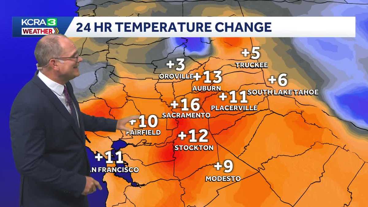
*** live look at downtown Sacramento and meteorologist Dirk Verdoorn, we hit the mark you thought we were going to. Yeah, we, we made our way into triple digits. First time for the month of July. Yeah, we had *** few days in June. But now we’re finally in July, usually think *** lot more of, uh, the heat, but it’s turning up and we’re feeling it. Live Copter 3 is flying over the valley over the Stockton area, looking off towards the east where you see just kind of ***, uh, traffic jam of clouds that are just billowing up and uh there are some showers and thunderstorms. *** lot of that activity though is happening on the east slope of the Sierra and it’s moving on towards Nevada. So this afternoon we have triple digits also in the forecast for tomorrow. So both days. They’re impact days because we are expecting temperatures at or above 100 degrees. It’s not going to be another warm night tonight, kind of like last night, even with the clear skies, temperatures should stay in the 60s to low 70s as we head into tomorrow morning. But Thursday we start to see things turn *** little bit cooler, and then Friday, the marine layer returns, and that really helps to drop off temperatures. So we just have to get through tonight, through tomorrow and tomorrow night as well. Looks like it’s going to be kind of on the warmer side before we really. Start to cool down, but here’s that thunderstorm activity we’re talking about. Let’s starting through the northern Sierra Pluma County, Lake Almanore, Chester area, seeing those thunderstorms pop up with some heavy rain coming down there. So you’re getting *** pretty good dose of rain. We’re also seeing scattered showers on into Lasson County, Susanville, kind of surrounding you in that area. We’re seeing some of those showers. Uh, Lake Tahoe proper, it’s dry. It’s not like yesterday. Boy, yesterday we had some good thunderstorms rolling across the lake, especially on the west side. Of the lake, but today it’s all just *** little bit pushed to the east, and so we’re seeing some pretty good thunderstorms in places like Silver Springs in Nevada. Arrington also getting some of those thunderstorms, but Lake Tahoe, not bad. Now farther south we’re seeing these thunderstorms in California. So Mono County is getting the bulk of the thunderstorm activity we’re seeing it’s just *** little corner here in, uh, Tuolumne County getting some of those showers, but most of them are near Lee Vining and, uh, the, uh, Mono Lake area. So Lake Tahoe, again, no thunderstorms, but we have some cloud. It’s some pretty clouds popping up and what’s interesting here is you can see that wind coming from the south kind of pushing those clouds along, shearing off the tops of them, not really letting them billow up any farther. So we have just this kind of *** layer, just *** more of *** shallow layer of convection that’s going on there over Lake Tahoe. Temperature currently 74 degrees. We’re at 81 degrees in Trucking, 100 degrees in Oroville, 104 in Fairfield, as well as Stockton. 03 in Sacramento and Modesto, so we have some serious heat that’s starting to develop with temperatures that are running anywhere from 9 to 16 degrees warmer in this area from Sacramento to Modesto and Fairfield, where 11 to 13 degrees warmer through the foothills and 5 to 6 degrees warmer for Truckee and Lake Tahoe. So we have this really warm air mass, this hot air mass that’s been sitting over the Four Corners area and it’s stretching its way across California. So now we pulled away the clouds that we had yesterday. And temperatures are really heating up. So let’s take *** look at what Futurecast is showing. Those thunderstorms will wind down tonight, and it looks like we shouldn’t have *** repeat. The only thing is, is we don’t have *** lot of onshore breeze. We need that onshore flow to really help to warm things up or cool things down, and we’re not going to experience that until we get into Thursday. And Friday, and that’s when we start to see conditions that are going to be cooling down *** bit. Here’s your seven day forecast with that. You can go from *** 102 tomorrow to 96 on Thursday to 90 degrees on Friday. That’s *** big drop. It is *** big drop, but yeah, we ought to get here eventually. Thank you, Dirk.
Meteorologist/Climate Reporter
Northern California forecast: More 100s Wednesday. Here’s when the heat eases.
An onshore breeze will gradually develop and help bring more comfortable weather back to the area.

Updated: 4:56 PM PDT Jul 14, 2026
Meteorologist/Climate Reporter
The Delta breeze on Monday is expected to continue influencing temperatures in Northern California to keep highs below average. Monday looks great for getting outdoors. The Delta breeze is helping to lower temperatures to start the work week. Valley highs are likely to be in the upper 80s to low 90s, while the Foothills could stay in the mid to upper 80s. The Sierra will see some afternoon clouds build with storm chances down the east slope, with highs in the low-to-mid 70s. Highs continue slightly below normal through Tuesday. Midweek, expect the heat to begin to build. Ridging begins to build from the Desert Southwest. As the ridge nudges closer to us, we will see Valley highs above average for this time of year starting Thursday. Feeling the heatPlan for highs across the valley from Thursday through Saturday, peaking in the upper 90s. The worst of the heat looks to hit on Thursday. Depending on where the ridge wobbles late next weekend, there’s a chance the heat could linger into the next work week.See more coverage of top California stories here | Download our app | Subscribe to our morning newsletter | Find us on YouTube here and subscribe to our channel | Make KCRA a preferred news source in Google
Northern California will face one more day of intense heat Wednesday before relief starts to flow into the region to end the week.
Wednesday is another KCRA 3 weather Impact Day because of the intense afternoon heat and the need to adjust outdoor plans.
An onshore breeze will slowly start to recover Thursday into Friday. As the marine layer returns, Valley temperatures will drop.
Friday will be noticeably more comfortable and dry with plenty of sun.
Clouds and chances for Sierra thunderstorms increase Sunday and Monday as another wave of monsoon moisture moves in from the south.
Wednesday forecast
Wednesday will be another hot day for the Valley and Foothills. It will start with a warm morning and very little wind. A gentle delta breeze will pick up in the evening, but cooling will once again be slow.
Temperature trend
More comfortable weather will be here soon. An onshore breeze will slowly recover along with the marine layer through the end of this week.
Weekend forecast
Saturday will be a nice, but warm day for any outdoor plans.
Monsoon moisture will move in from the south on Sunday. This could lead to more Sierra thunderstorm chances. Those with plans in the mountains should check back for updates over the next couple of days.
Long range outlook
The extended outlook continues to favor warmer than normal temperatures for the West for the next couple of weeks. Sacramento’s normal high temperature is 93 degrees.
Foothills & Sierra 7 day forecast
The next few days will be dry and hot on the west slope.
There is a chance for more scattered showers and thunderstorms int he Sierra Sunday and Monday with another round of monsoon moisture moving in.
Valley 7 day forecast
Wednesday is a KCRA 3 weather Impact Day for another round of intense afternoon heat. Thursday and Friday will gradually become more comfortable as the onshore breeze recovers.