
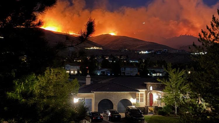
The Hawk Fire in Washoe County, Nevada, has burned about 13,000 acres, according to Hawk Fire officials during a news conference Sunday morning. Officials said the fire was human-caused. They added that stronger winds are expected to return Sunday afternoon and could push the fire more towards north.
As of 12:30 p.m. Sunday, the fire was continuing to push north toward the Long Valley area of Sierra County, according to the Sierra County Sheriff’s Office. The fire had not reached Sierra County. Deputies are monitoring conditions.
The fire has burned south toward Somersett, then northeast over Peavine Peak toward U.S. 395, Golden Valley and Cold Springs, according to Truckee Meadows Fire.
About 42,000 people are under evacuation orders and another 45,000 are being told to prepare to leave. Officials are urging people in evacuation warning areas to leave early if possible as strong winds are expected Sunday afternoon.
Three civilians and three first responders have been injured. Officials also confirmed structures have been destroyed, but crews have not been able to safely assess how many.
All Washoe County School District classes except for Gerlach K-12 School are canceled tomorrow Aug. 24.
Sierra County Evacuation Warnings:
Zones are located in the Verdi area and Long Valley area of eastern Sierra County.
Evacuations Shelters in Nevada:
Reno-Sparks Convention Center, Hall 4, at 4590 S. Virginia Street, Reno.
Access the evacuation center from Kietzke Lane and enter through Door 20F on the Kietzke side.
Small Animal Evacuations:
Please do not bring pets to the evacuation center. Small animals can be taken to:
Washoe County Regional Animal Services at 2825 Longley Lane
Large Animal Evacuations:
Ironwood Event Center at 5600 Whiskey Springs Road Reno, NV 89510
Current Road Closures:
• US 395 at Bordertown
• US 395 at Village Parkway
• US 395 at White Lake Parkway
• North Virginia Street at White Lake Parkway
• Northbound US 395 at Red Rock Road
• Southbound US 395 at Stead Boulevard
• Stead Boulevard at Matthews Street
• North Virginia Street at Panther Drive
• North Virginia Street at Parr Boulevard
• North Virginia Street at East Golden Valley Road
• Mae Anne Avenue at Somersett Parkway
• Del Webb Parkway at Somersett Parkway
• Robb Drive at Los Brisas Boulevard
• Lemmon Valley Drive at North Virginia Street
• Golden Vista Avenue at North Hills Boulevard
• East Golden Valley Road at Beckwourth Drive
• Red Rock Road at North Virginia Street
• Stead Boulevard at North Virginia Street
• Sharlands Avenue at Mae Anne Avenue
• Beaumont Parkway at Avenida de Landa
EVACUATION MAP:
WILDFIRE PREPS:
If you live in a wildfire-prone zone, Cal Fire suggests creating a defensible space around your home. Defensible space is an area around a building in which vegetation and other debris are completely cleared. At least 100 feet is recommended.
WATCH: What you need to know to prepare, stay safe for wildfires
The Department of Homeland Security suggests assembling an emergency kit that has important documents, N95 respirator masks, and supplies to grab with you if you’re forced to leave at a moment’s notice. The agency also suggests signing up for local warning system notifications and knowing your community’s evacuation plans best to prepare yourself and your family in cases of wildfires.
Some counties use Nixle alerts to update residents on severe weather, wildfires, and other news. To sign up, visit www.nixle.com or text your zip code to 888777 to start receiving alerts.
Read more: Are you wildfire ready? Here’s what to do to prepare for fire season.
PG&E customers can also subscribe to alerts via text, email, or phone call. If you’re a PG&E customer, visit the Profile & Alerts section of your account to register.