
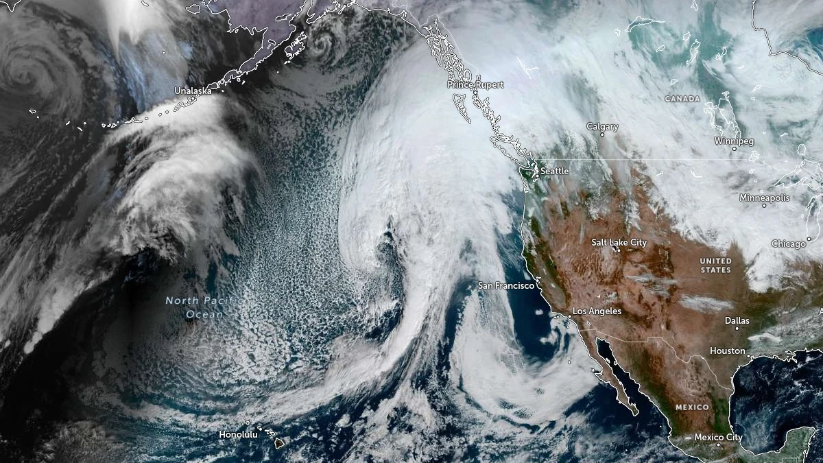
Forecast models indicate that a low-pressure system will cut off from a trough moving across the Northeast Pacific between Sunday, November 9, and Monday, November 10, before stalling northeast of Hawaii.
The system is expected to strengthen as an upstream trough amplifies, enhancing tropical moisture transport from the Eastern Pacific. This process will facilitate the formation of an atmospheric river directed toward the U.S. West Coast by mid-week.
According to CW3E’s Quick Look issued late November 7, both the Global Forecast System (GFS) and European Centre for Medium-Range Weather Forecasts (ECMWF) deterministic models show relatively good agreement on the timing and location of AR landfall. However, uncertainty remains regarding the strength of the system and its evolution after reaching the coast.
CW3E’s AR Landfall Tool, based on the Global Ensemble Forecast System (GEFS), shows a greater than 90% probability of integrated vapor transport (IVT) ≥250 kg m⁻¹ s⁻¹ along the California coast beginning early Wednesday, November 12.
The GFS deterministic solution suggests a slightly later landfall, late on November 12, while the ECMWF ensemble (EPS) forecasts a delayed onset and prolonged duration through Saturday, November 15.
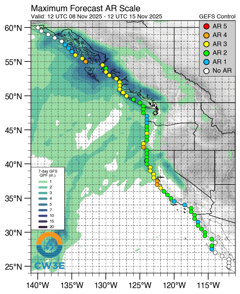 Image credit: CW3E
The GEFS currently indicates AR 1–2 conditions (based on the Ralph et al. 2019 AR Scale) along coastal California south of the Monterey Peninsula and across the Washington and Oregon coasts.
Stronger AR 3 conditions are likely in Northern and Central California, where 30–60% of ensemble members predict higher IVT magnitudes and longer-duration moisture transport.
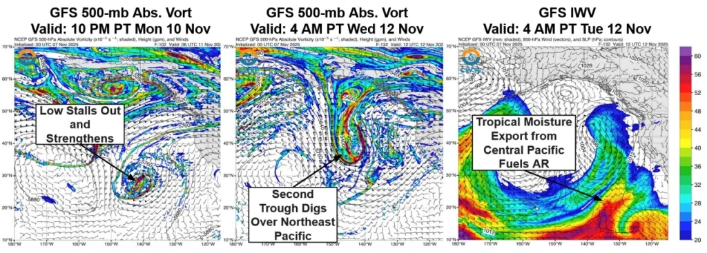 Image credit: CW3E
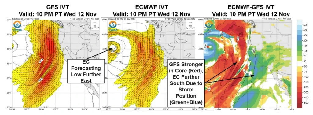 Image credit: CW3E
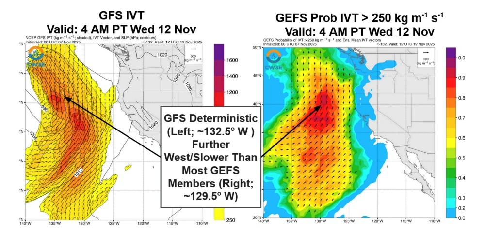 Image credit: CW3E
CW3E’s Watershed Precipitation Tool shows considerable variability among ensemble members. In the Russian River watershed, total precipitation over the next 10 days ranges from less than 13 mm (0.5 inches) to more than 100 mm (4 inches).
The GEFS leans toward higher totals in Northern California, while the ECMWF EPS favors greater precipitation along the Central and Southern California coast and in the Southern Sierra Nevada.
The Climate Prediction Center’s (CPC) Day 8–14 Hazard Outlook indicates a moderate risk of heavy precipitation across the Northern and Central Sierra Nevada and Transverse Ranges, as well as a moderate risk of heavy snowfall over the Sierra Nevada for November 15–16.
While both global models align on the general timing of the AR event, ensemble spread remains high. The GEFS ensemble shows an earlier onset and shorter duration, while the ECMWF EPS suggests later landfall with a stronger southern extension.
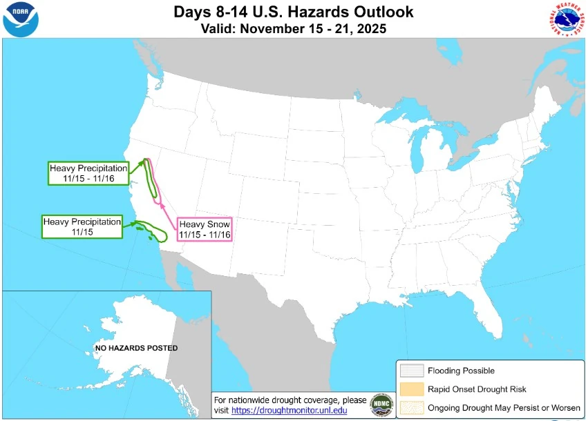 Image credit: NOAA/CPC
The position and evolution of the cut-off low northeast of Hawaii remain key factors controlling both the AR strength and how far south moisture extends.
CW3E notes that this system will be dynamically linked to a broader pattern featuring an amplifying ridge over the U.S. West Coast and an active downstream trough over the central United States. These competing large-scale features will influence the strength and trajectory of the AR as it approaches California.
According to the National Weather Service (NWS) Weather Prediction Center, a strong cold front will move through the Central United States this weekend, bringing snow and high winds from the Northern Plains to the Great Lakes.
A frigid continental airmass will descend southward behind the front, while the Western U.S. warms under an upper-level ridge. The Storm Prediction Center warns of a critical fire weather risk for southern Texas on Sunday, November 9, as dry, windy conditions develop.
References:
1 Atmospheric River Outlook – CW3E Quick Look – November 7, 2025
2 Short Range Forecast Discussion – NWS/WPC – November 8, 2025
3 Day 8–14 Hazard Outlook – CPC/NOAA – November 7, 2025